 |
| Broken Remains |
It’s a funny thing about walking in the winter; you can plan routes all you like but in the end it seems that it’s the weather that ultimately decides where you end up going! So it proved today. After a week of weather forecasts telling me that just about everywhere that was practical to go was due heavy rain, a window of opportunity opened up in Hastings
 |
| Sorry State |
The official start to my walk would be Hastings station, but I felt that it would be remiss of me not to look at the fire damage sustained by Hastings Brighton ’s West Pier and one of the buildings has remarkably remained intact. While the general outlook for the pier appears gloomier than ever, it’s near complete destruction has galvanised the community into raising money to pay for its restoration and enough remains intact for this to be possible. There is no doubt though that it will be a massive job, swallowing lots of cash. I wish them well in their endeavours. If you want to find out more visit their website at http://www.hpwrt.co.uk/ .
 |
| Six! |
I parked at Hastings Rye
 |
| Seafront Buildings |
I wandered down through the town centre passing Priory Meadows shopping centre and coming across a rather odd looking statue of a cricketer depicted hooking a shot behind. I say odd, because it looked rather an unnatural stance for a cricketer and I suspected that it was sculpted by someone who hasn’t actually played the game. It did remind me though that the shopping centre was once the central cricket ground, used occasionally by Sussex County Cricket Club as an out-ground. I suppose it was too much to ask that a town centre location like this could ever stay being a cricket ground forever, but I thought it very sad that it was replaced by something as mundane as a shopping centre. The last match was played here in 1989, against Kent
 |
| East Cliff |
Although the cricket ground is long gone, it was heartening to see that the Odeon cinema was still functioning and opposite was a small turret boasting the best burgers in town. I couldn’t help thinking that was quite a feat since there seemed to be standing room only inside for the server! I headed off towards the old town, by far the most interesting part of Hastings Hastings Rock-a-Nore Road
 |
| Heading Along the Coast |
I was pleasantly surprised at how easy the climb was, but then I have become used to South West Coast Path type cliffs which are rather more of a test! At the top by the upper station I lingered for a couple of minutes admiring the view back over the old town before trudging on. The wet weather that we had had over the preceding few days was certainly noticeable, with the grassy cliff tops of Hastings Country Park
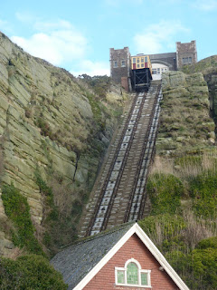 |
| East Cliff Funicular |
Having walked the next few miles in reverse when I walked the Saxon Shore Way nearly six years ago (crikey – is it really that long ago?), I was more prepared for the ups and downs of the next few miles through the Park. First I dropped down into Ecclesbourne Glen, probably the most picturesque of the three Glens I would have to cross and yet the one I appreciated least on my last trip as it was so unexpected! Yet despite the usual rollercoaster type terrain associated with cliff walking this wasn’t nearly as challenging as I remembered (although it helped that I was fresher in this direction!). As I climbed up and out of the Glen the view back towards Hastings along the cliffline is impressive although I still have a hard time getting used to seeing cliffs in Sussex that are not chalk!
 |
| Hastings Old Town |
After the relative excitement of Ecclesbourne Glen, the next mile or so of walking is a bit dull if I’m honest although that may have had more to do with me trying to pick my way through the endless mud than any sleight on the countryside! I then came to Warren Glen, which wasn’t such a descent as the previous one, but was rather more wooded (which seemed to add to the mud!). By now though the sun was well and truly out and this seemed to give me an extra amount of energy, good enough to help me up on to the next cliff.
 |
| Hastings View |
There was little ridge this time and I was soon descending once again, this time down into Fairlight Glen, the last of the three. From here I knew that the final ascent would be the last major climb of the day and although it wasn’t that hard I was nonetheless quite relieved to get all the climbing out of the way nice and quickly. At the top of Firehills, the intriguingly named hill above Fairlight, I paused to watch the rather hypnotic spinning of the radar station, which still operates here. I think it is a coastguard station still, although the houses next to it should confirm its original use for they are coastguard style through and through!
 |
| Hastings Country Park |
As I passed by I became aware of the rather annoying cloud that had temporarily blocked the sun. Having done so I thought briefly, the cloud then started to build and before long it looked like my beautiful sunny day would become overcast and dull L. I headed down Firehills through gorse covered country (starting to flower – a sure sign that the end of winter is coming) and soon encountered Fairlight Cove, a rather soulless piece of suburbia that has been plonked on top of the cliffs. My route would have to pick my way through the streets of this rather dull place until eventually I came upon countryside once again in the shape of a small area that has been acquired by the National Trust. This would be my last piece of cliff top walking for the day, for about half a mile later I came to Cliff End, and the view onwards confirmed that I had now reached the western end of the piece of coastline dominated by shingle that would eventually become Dungeness. I dropped down off the cliff top and headed for the sea wall, past the first of many caravan sites. I was amused to notice that at the edge of the site was a fly-tipped chocolate brown toilet bowl. I couldn’t help thinking that it might be part of the ‘facilities’!
 |
| Top View |
What followed was almost an hour-long walk along the sea wall to Winchelsea Beach Saxon Shore Way Rye
 |
| Fairlight |
Eventually I reached Winchelsea Beach Winchelsea
 |
| Cliff End |
The walk along the sea wall passed by yet another dreaded caravan park but largely avoided the main housing area until eventually I can to a slightly strange looking area of playing fields. I say strange because the football pitch was in a slight hollow, like the whole thing had been engineered that way. My suspicions proved to be correct when I noticed from a nearby signboard that this was at one point going to be a substitute location for Rye Harbour
 |
| Rye Marshes Coast |
Just after the failed harbour I left the sea wall for good and headed across the nearest footpath to the coast at this point, across Rye Marshes, a nature reserve. For awhile the path followed an unmade road that serviced a ribbon development of housing mostly of 1920s and 1930s vintage. I was pleased to see that several of the houses were made up from old railway carriages and one in particular caught my eye as it was actually four railway carriages arranged in a square. I could only assume that there was a quadrangle in the middle.
 |
| Winchelsea Beach Cafe |
Eventually the housing petered out and the path continued around a number of very large gravel lakes, perhaps giving a hint as to why this area is now a nature reserve. Gravel extraction appears to have mostly stopped although there are plenty of old machines left behind as a testament to the former industry. Now the gravel pits are deserted, save for the odd birdwatcher (I passed a few) and the calls of the birds that frequent these watery holes in the landscape. Across the first of the gravel lakes I caught a glimpse of Camber Castle , some distance away and passed on a very snowy Saxon Shore Sussex
 |
| Railway Carriage Home |
I also passed by another scene of dereliction, this time Rye Harbour Farm. This place was bought by the Environment Agency many years ago when the sea defences were built. The farm had helped degrade the natural environment through its intensive arable farming practices but now the Agency has given it a new lease of life by getting a new project underway to help enhance the wildlife in the area, such as it would have been when the farm started production. Now the place looks a bit of a mess and badly in need of being tidied up.
 |
| Distant Camber |
I soon reached Rye Harbour Rye Rye Sussex tourist scene but for me, after thirteen miles of walking I was ready to get the bus back to Hastings
 |
| Rye Harbour Farm |
The walk from Rye to Hastings Sussex
 |
| Entering Rye |
I am almost done with the Sussex Coast Rye