Thursday 23 May 2013

South West Coast Path Section 19 Perranporth to Portreath


Perranporth
A couple of years ago when I was down this way I had managed to arrive before the summer timetable of buses started and so was unable to complete the section between Perranporth and Portreath without some lengthy bus journeys between the two villages.  With one more day of good weather forecast I was determined to put this right on this trip and therefore closing the only gap between Padstow and Porthleven.  Even with summer timetables there was only a couple of buses a day and so I had the choice of starting a lot later than I would have wanted or the worry of making the bus at 4.30pm in the afternoon.

Droskyn Castle
In the event I opted for the latter option, thinking that I had more than enough time to complete the day’s walking with enough time to have a cuppa at the end.  Doing the trip this way round also meant that I would save about 25 miles of unnecessary driving.  I pulled up at Perranporth at about 9am and found an on-street parking spot, not wanting to be stung by the all day parking charge that I had done last time here.  Luckily it was early and gloomy enough that I didn’t have to worry about all the free spots being taken.

Shag Rock View
I made my way down to the cliff edge to reunite with the coast path.  It was windy and dull, not the sort of day I had imagined from the weather forecast at all.  I had to button myself up against the cold as I took a look across the beach and the rather novel looking sundial. It was rather impossible to tell the time on such a day though!  My way forward took me up past the youth hostel and a rather strange looking castellated building that I gather is now a hotel.

Interesting Rocks at Cligga Head
From this point on my walk took me along the wild cliffs that once housed a metal mining area known as the Cligga.  Initially the cliffs were rather similar to the last section along from Newquay, although I soon lost the beach below.  After a couple of miles though the cliffs were scarred from the pollutants generated by the mining activity and it looked as if some hasty engineering had to be put in place to prevent the path collapsing into the sea.  At Cligga Point the remains of the old mine buildings could be seen, although there mostly foundations left.  By now the clouds were blowing away, revealing some magnificent views ahead.
Former Mine Buildings at Cligga Head

Off to my left I soon became aware of the airfield off to my left.  Now largely deserted I believe it still has some use for pleasure aircraft and judging by the number of picnic benches provided around the perimeter and on the path I am guessing that the owners are trying to raise its profile a bit.

Hanover Cove
The onward walk to St Agnes was delightful, with the clouds blowing right away and the sun coming out in a blaze of glory.  The sea below was pretty choppy and I could see white horses on the water for as far as the eye could see.  Way out in the sea I could see a large tanker, anchored about 3 miles offshore and a sight that I would be able to see for the remainder of the day. 

Looking Back to Hanover Cove
Once past the far end of the airfield my clifftop walk came to an abrupt end at Crosscombe as the path dropped down into a steep valley that housed a couple more old tin mines.  The furthest one from the shore apparently still works and can offer tours around but when I approached I notice a sign saying that no tours were being offered during 2013.

Approaching St Agnes
I crossed the small river at the bottom of the valley and climbed up the steep slope the other side, an unmade road that was used for a regular motorcycle event that runs from London to Lands End (details needed here).  Walking across the rough terrain wasn’t all that easy so I couldn’t imagine trying to ride a motorbike across it.  Eventually I came upon the pretty beach and cove at St Agnes.  The village itself is largely up on the hill above the path but there is a beachfront of sorts and it was obvious from the galleries and other shops selling tourist stuff that there is enough in the way of summer trade here to keep people going.  Sadly the clouds had come back at this point and as I headed around to St Agnes Head I kept looking at the sky, hoping that they would shift in time for the main highlight of the walk, the famous engine house at Wheal Coates further along the path.

Trevellas Coombe
Although the walk up to St Agnes Head was quite quiet as soon as I rounded the headland and the coastwatch station on the top the crowds started once again.  Ahead and I could see the main attraction – the old engine house at Wheal Coates and surely the most photographed of all the engine houses in Cornwall?  The mine itself has now not operated for 100 years closing for the final time in 1913 after a short stint being reopened.  The original mine operated from 1802 until 1889 and the derelict engine house is now ironically a grade II listed building.  I cannot imagine a derelict structure from the late 20th Century being afforded such protection in a few years time.

Trevellas Tin Mine
The engine house itself was every bit as spectacular as I’d hoped.  I hung around for a bit waiting for the clouds to shift around enough that I could get some good pictures of my own.  I also had to wait quite a time to make sure I got all the tourists out of the shot too. Having a number of people swarming around the old place kind of detracted a little from how it looked.

Trevaunance Cove
I was relieved to drop down on the coast path away from the strollers and headed down into Chapel Porth.  The chapel wasn’t particularly obvious and I walked past it before I realised.  The hatch in the National Trust car park was quite busy although the menu wasn’t particularly promising so I decided to push on to Porthtowan instead.

St Agnes Head View
This involved yet another climb back on to the cliff tops for a short distance.  As I did so the weather relented once again and the sun made a welcome reappearance.  The rest of my trip today would be characterised once again by glorious clifftop views and by now the shape of St Ives came into view on the very far horizon.  Strangely though the ship offshore didn't seem to get any closer looking!  It didn't take long to get to Porthtowan and I entered the small beach resort past a swanky looking eating spot that seemed very popular today.  Most of the diners though were still inside, preferring not to brave the stiff breeze outside.

Wheal Coates
Upon seeing a small runabout bus waiting at the bus stop I decided to see if there were any more bus options since it was a lot earlier than I expected by this point.  I was delighted to note that there appeared to be an extra bus from Portreath back to Perranporth in just an hour and twenty minutes from now and decided that I would try and cover the remaining four miles in the time left.  I stopped in the shop and seemed to find the only one in Cornwall that didn't have any pasties for sale which was a huge disappointment.  The small number that were bagged up were allegedly for another customer.  The shop girl smiled sweetly enough so I like to think that me ending up with a sausage roll instead wasn't due to me being a 'foreignor'.

Chapel Porth
The sprint was now on and I put my foot down and motored the final section across to Portreath desperately wanting to get there before this elusive bus so that I could have an earlier return home later.  Initially the going was pretty easy and I made very good time along the mostly flat clifftops.  However, once past a large daymark my progress forward was interrupted by a couple of steep drops and equally steep climbs on the other side.  Yet somehow even these obstacles didn't really slow me down and I made excellent timing along here.

Looking Back to Wheal Coates
On the shore side of my path I became hemmed in by a fence surrounding what was clearly a military establishment.  There was a large installation that I supposed was for radar purposes since it looked like a rather big golf ball.  The rest of the base had an air of secrecy about it, with only parts of the buildings being visible and adding to the sense of mystery.  I understand that it has served as both an RAF station and a chemical warfare base.

Porthtowan
The last big coastal feature of the day was Gooden Heane Cove, a large area of cliff that had been scooped out by the sea and which seemed to be much favoured by the local seabirds.  Sadly for me the path down into Portreath was blocked by yet another cliff fall and so I took the less pretty but infinitely quicker road.  You can only imagine my frustration at reaching the bus stop five minutes earlier than the billed time only to find that I had been rushing for a phantom bus!  After a few mumbled expletives I realised that the bus timetable published at Porthtowan must have been out of date for the one here at Portreath seemed to have the bus times that I had been expecting.

Porthtowan Daymark
I wandered down towards the beach and holed up in the beachfront cafe for a mug of tea.  The sun was fully out now and it was enjoyable just sitting and relaxing after the effort I had expended getting here.  I now had two hours to kill before the bus!  The mug of tea was very welcome and strong.  At just £1 it was probably the best cuppa I had had in a cafe for years!  Importantly I could also easily afford a second.  I sat and watched the activity out on the beach, which for the most part seemed to revolve around hundreds of university students from East London.  I am guessing from their surveying equipment etc that they were either Geography of more likely Geology students.  A lot of them were taking up cafe seats which didn't please the prospective customers who couldn't find anywhere to sit.  Sadly their antics also meant that before long I too was on the move and decided to spend the rest of the time waiting at the bus stop reading the paper instead.


Gooden Heane Cove

This was a brilliant way to end my time away.  As with the last time I came down this way I felt that I still had plenty left in the tank for a few more days.  Sadly I don't know when I am again going to have the opportunity to get down here, but went home happy that I have now completed 420 miles of the whole hike and am therefore two thirds of the way to completion :)

Portreath

Thursday 16 May 2013

South West Coast Path Section 33 Mevagissey to Par

Mevagissey Harbour

After a rough couple of days weather it was a relief to see sunshine once again and I was anxious to go and do a section of previously unwalked path.  I headed over to Par and from there got the bus to Mevagissey.  This was a bit of a long winded journey through St Austell and I think I saw every housing estate that exists in this corner of Cornwall I was most relieved to reach my final destination after an hour or so.

Maintenance Time
I stocked up on refreshments and wandered along to the attractive harbour in Mevagissey.  There were plenty of boats in the harbour but sadly little in the way of fishing activity, which I guess used to be the main activity here.  In fact the only activity on the water was a small boy precariously rowing a small boat around.  I could hardly bear to look as he looked like he would topple into the water at any moment.
Penare Point

As I wandered around the harbour I could see a couple of boats receiving some attention at the far end.  They looked faintly ridiculous out of the water and leaning over on their keels but I guess this is the only way in which they can be painted.  I wandered out on to the harbour arm of the outer harbour, a rather curious arrangement that I suppose was built to reduce the worst effects of the winter storms.


Pentewan
I could have spent a lot longer walking around the harbour but I still had twelve miles of walking in front of me so I headed out through the steep and narrow streets up on to the cliff tops.  The way ahead was a bit of a rollercoaster for awhile, with the path heading uphill and down dale for the next few miles.  I was thankful though for plenty of sunshine, which made a lovely change from all the grey skies I had encountered during the week.  I was surprised at how quickly I left Mevagissey behind and due to the direction that the coast path travels it disappeared from view very quickly.

Point of Well

Ahead the bay at Pentewan soon came into view, with its large expanse of holiday caravans behind the beach.  As a spectacle I am not a great fan of these places, but the location of this one must make it extremely popular during the summer months.  There wasn’t a great deal of activity on the park this early in the season, but there were a few people on the private attached beach.  I passed by an abandoned fishing station, one of many on this stretch. I believe most of them were involved in the pilchard fishing industry.  I am not even sure this exists any longer?

Stonechat

I passed along the back of Pentewan caravan park and headed into the adjacent village.  This was a peaceful and attractive place with the inevitable water sports shop as well as village shop.  What was unusual though was the artificial harbour built in the village.  I am guessing judging by its appearance that it is no longer used but in its day it was used by china clay traffic.  Now, the harbour is completely silted up and cut off from the sea.
Wood Carving at Drennick

The path left the village by a track that passed an old church and some beautiful looking houses that overlooked the bay.  At the back I by-passed some chaps renewing a boundary fence to the properties and thought what a lovely place and day it would be to work.  My way forward now was along the clifftops to Black Head, a promontory some distance ahead.  Along the way the path climbed and fell along an undulating course that was quite tough going.  The views more than compensated though and all along the way I was joined by all sorts of bird life and not just the expected seagulls but blackcaps, robins, blackbirds, sparrows.  I even came across another stoat – the second that I had seen on this trip away.

Black Head Cove
Eventually I came to the final headland of Black Head and the cove at the western end had the most delightful cottage overlooking it.  I am guessing that it must have been occupied by an artist at some point because there were two fantastic looking sculptures in the back garden that had been carved from tree stumps.  The cottage itself was some distance from the nearest road, which must make delivering stuff a bit of a challenge (can’t imagine Tesco sending deliveries there!).  I’m not sure I would want to live there full time, but as a holiday cottage I can’t think of many more idyllic spots.
View to Drennick

As I approached Black Head I passed by a very large and unusually plain looking memorial to the famous Cornish poet A.L.Rowse.  I took the opportunity to walk out to the headland even though it wasn’t on the official route.  I passed by another pilchard station on the way and headed up on to what was once an Iron Age Hill Fort.  These seem to be fairly common in Cornwall, something I hadn’t previously realised.  I guess the metal riches and plentiful fishing opportunities brought many of the Iron Age people down here and these headlands made for easily protected places to live.  Sadly I didn’t gain much from going out to the headland so I didn’t hang around too long.
A L Rowse Monument

As with all headlands though a new view opened up and ahead of me I could now see the china clay hills that I have heard being referred to locally as ‘The Alps’.  They do make for a rather unusual landscape that is unmistakably Cornish.  Across the bay and I could see the candy striped marker at the Gribbin.  As I looked I could see a helicopter buzzing towards me and as ever my immediate thought was that someone might be in trouble out on the water.  It rushed by looking like it was making a longer journey and I felt relieved.
Me at Black Head!

The onward route to Charlestown started out quite easy with some very pleasant cliff top walking.  I got distracted by the wild flowers growing along the side of the path though and shortly after passing a rare walker I took a wrong turn and started heading downhill towards Ropehaven.  I didn’t realise my mistake until I was almost at the shoreline and cursed as I had to retrace my steps up the steep path back to where I should have headed.  The bright sunshine that I had enjoyed for a while also gave way to cloud and I prepared myself for a rain shower, which thankfully didn’t come.
Silvermine Point

The onward path soon got a lot trickier with a couple of steep ascents and descents in quick succession including a pretty mammoth one at Silvermine Point.  I passed a couple of old codgers here and tried to not to show myself up by crawling up the hill they were taking slowly and steadily.
Porth Pean 

Eventually I came to Porth Pean, a beautiful secluded little beach that had attracted a few visitors on this rather unsettled looking day.  My guidebook suggested that I might need to head inland along a detour here, but to my relief the official path had now been re-opened.  I climbed some steep steps and found a lookout tower at the top which I couldn’t pass without a closer look.  A little further on and I could see the erosion that had precipitated the earlier closure and the fact that some of an adjacent garden had had to be commandeered in order to fashion a new stretch of path.

Earl of Pembroke at Charlestown
I stopped by at Crinnis Cliff Battery but by now the threatened shower had finally arrived and so I hurried down into Charlestown and took the opportunity to hunker down inside the shipwreck museum to ride out the rain.  It was a curious little place with a little on the history of the historic port of Charlestown.  This rather historic port has been largely by-passed but was once a hub for local china clay quarries and shipping out of the mined product.  It is now preserved in time and the image was complete with the visit of the Earl of Pembroke, a very attractive looking tall ship moored in the harbour.  Although there was some information about the harbour, the museum soon became a rather jumbled and confusing mish-mash of all things nautical including shipwrecks, rescue services and disasters at sea, some of which weren’t really associated with Cornwall. Perhaps the most interesting part for me was seeing the various wrecks around the Cornish coast, for some of them I had seen or heard about on my walks around the coast path.

Charlestown Shipwreck & Maritime Museum
After about half an hour of the museum I was ready to carry on.  I thought about having a cuppa in the adjacent restaurant but it didn’t really look the kind of place to just have a cuppa so I carried on.  The onward path from Charlestownwasn’t initially very interesting as I headed through the suburbs of St Austell, but I soon came upon a rather curious looking place on the area under the cliffs.  It was clearly going to be redeveloped but I couldn’t decide what it was.  It sort of looked factory like and yet it didn’t.  I later discovered that this was once an entertainment centre where large acts would once come and perform.  It had a successful life until a similar venue was built in Plymouthand no-one much fancied heading out into the wilds of Cornwall any more!
Approaching Par

My last stretch of coastal walking for the day was alongside a golf course.  A few hardy souls were out but I couldn’t imagine that playing golf on such a windy day would be much fun.  The wind though did bring up some wonderful sea and skyscapes for the next couple of miles until I came to Par.  At the china clay works the path headed abruptly inland and I had to negotiate around the edges of what now looked like a closed and derelict works.  Indeed when I checked later I saw that the bulk of the operation had been closed since 2007 and I am guessing that there will be quite a challenging time ahead for the local planners trying to find an alternative use for the extensive site.
View from Par Golf Course

For me though my journey was done and the weather had closed in once again.  Although perhaps not the most memorable sections of the coast path I really enjoyed my visit to Mevagissey and Charlestownwas memorable too.  The best of the coast line was between these two places and especially around Black Head.  If time I would recommend the museum at Charlestown – despite the chaotic nature of some of the exhibits it is worth a tour around for an hour or so.

Sunday 12 May 2013

Plym Valley Trail


Yelverton Church
A change of pace following all the coastal walking of the previous few days. On this particular day the weather forecast looked particularly poor and yet there was a short window of opportunity to walk so long as I made an early start.  I decided therefore to take a trip down memory lane and walk the old railway path between Yelverton and Plymouth.  This was one of my favourite winter walks while I was at University in the city since it was one of the few walks I could do easily without a car and/ or extensive planning.

Drakes Leat
The Plym Valley Trail follows the former Great Western Railway line from Plymouth to Tavistock.  The town of Tavistock managed to have two rail connections to Plymouth (the other was run by the London and South Western Railway) and yet both were severed by the Beeching Cuts of the 1960s.  This particular route was closed in 1962 and converted into a cycle path from Marsh Mills on the outskirts of Plymouth (at the site of the old junction) to Yelverton some years later.  Such was the popularity of the path that it has been extended as The Drakes Trail to Tavistock, but on this occasion there wasn’t time to look at the northern section.

Dartmoor View
I parked just outside the church in Yelverton.  There are plenty of facilities in the village to stock up with refreshments before heading off.  I followed signs for the West Devon Way, a long distance footpath that heads through Yelverton and coincides with the Drakes Trail for a short distance.  I soon picked up the trail of Drake’s Leat, a rather strange watercourse that was (as the name suggests) built by Sir Francis Drake to supply water to Plymouth from the upland parts of Dartmoor.  There was no water in the leat, the supply from Dartmoor now merely ends up in Burrator Reservoir, rendering this section rather redundant.

Meeting the Railway
After following the leat for a short distance I turned downhill along the West Devon Way to reach the embankment of the former railway.  Sadly it is not possible to walk this section at the route is far too overgrown.  The path maintains a course almost parallel to the railway for a couple of miles and in a couple of places it is possible to access the trackbed and inspect the line.  As I had thought with the Wye Valley Railway, this particular line was surely closed a few years too early.  If it had managed to hang on even just a few more years it would surely have been scenic enough to attract the attention of a few preservationists.  As it happens there is a small preservation project going on some distance to the south of here, but it seems doubtful that they would ever make it this far along the line.  More about that project later.
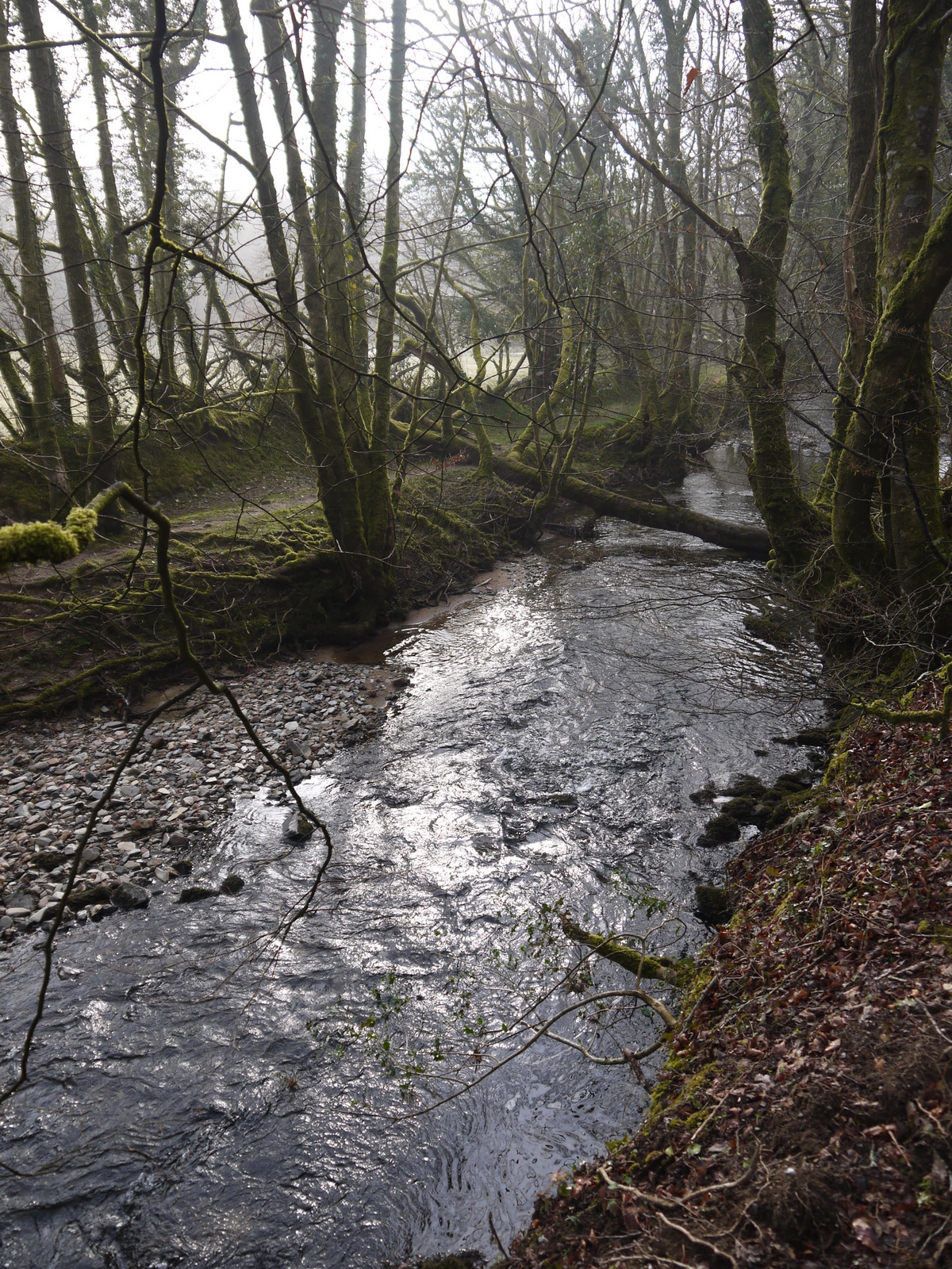
River Plym
The path initially followed the railway quite closely, usually at the edge of the former boundary but as it approached Clearbrook the railway took a higher level course, while the path dropped down to follow the River Plym more closely.  This is a delightful part of the walk and it was helped by some weak misty sunshine which added to the atmosphere of the woods.  Alongside me the River Plym babbled and spluttered down through the wooded valley.  The woods though were surprisingly quiet, very few birds around which was rather surprising.

Clearbrook
At Clearbrook the railway once had a station, although it was pretty modest and only consisted of a small platform and metal shelter.  The path I was taking was some considerable distance from the railway now and could only be seen in the distance.  I very much doubt whether the station is still in existence now.  I did admire the small hump backed bridge that crossed the river at this point and as I crossed the field opposite a couple of curious horses waded the river to come and say hello.  Eventually half a mile or so further on I was able to finally join the railway itself as it crossed a road.


Clearbrook Bridge

I seemed to recall that the surface of the railway path had once been compacted stone for most of the northern section but as the rail route started properly here it had a tarmac surface from this point onward.  This would make walking both a blessing and a curse.  Although it makes for nice clean walking, tarmac is quite hard on the feet after awhile and it is much easier to cycle on.  I was slightly disappointed not to have brought my bike, for I could have cycled the whole route from Tavistock then.  However, it isn’t so easy to stop and look at stuff then.

Shaugh Tunnel
Shortly after joining the track I came across my first proper railway feature – Shaugh Tunnel.  When I last walked this way entering the tunnel was a slightly scary prospect as the tunnel is built on a slight curve, meaning that it is impossible to see one end from the other.  Back in the late 1990s the tunnel had no lighting and it was a very dark and damp experience walking through.  Now, knee high lighting manages to deal with most of the health and safety requirements without causing a nuisance to the bats that have been roosting here since trains ceased running.
Drake's Leat Crossing

At the other end of the tunnel the line is crossed by Drake’s Leat once again via a well engineered bridge.  I am not clear whether this was provided by the railway company when the line was constructed or whether it was a much later inclusion when the authorities refurbished the Leat in case it was needed during World War II.  The line continued southwards on a shelf like part of the slope of the valley, largely through woods that at least afforded views outwards towards the higher moorland beyond.
Shaugh Bridge Halt

Soon after and I passed the only intact station left on the line at Shaugh Bridge.  This was only ever a halt station and opened in 1907, some 46 years after the line opened.  I am not sure that there were any more facilities during the period it was open than there are now!  Heading south and the next feature on the line is the massive 6 arched Ham Green viaduct.  This carries the line high above a small tributary valley of a stream that flows into the River Plym.  On the left hand side of the viaduct the stumps of a former viaduct can be seen.  I imagine these were from an earlier wooden structure – such features are quite commonplace in Devon and Cornwall.

Ham Green Viaduct
Last time I headed this way there used to be a very annoying diversion at a point just south of the viaduct where it met the road that served Bickleigh Station.  Then it was necessary to head up the road a short way and loop around to meet back with the railway.  Now thank goodness that palaver is no more as a new route around the site has been constructed.  Although off the line of the railway, most people wouldn’t really notice as it runs just a few yards to the east and to all intents and purposes is just a continuation of the route.
Site of Bickleigh Station

For a short section through the cutting to the south of the site of Bickleigh Station the path acquires some road markings.  The need for these was amply demonstrated by a dog walker in a disabled buggy.  Apparently the markings are to remind people that this section is used by these kinds of vehicles.  Perhaps that is why the surface has been tarmacked?

Viaduct with Stumps
Heading south and the line became a lot more wooded as I entered Plymbridge woods.  The line headed across two more large viaducts and on each occasion I took the opportunity to have the best look of them that I could.  The problem with walking across these structures is that although perfectly possible to appreciate their engineering it is almost impossible to appreciate their design without looking from a different angle.
Plymbridge Woods Section

I could tell that I was now reaching the end of the line as there were by now many runners using the line.  I should imagine that it is a good route for running.  The surface is even but the route far more interesting than pounding the pavements around the city.  The section through Plymbridge Woods is delightful, perhaps the most scenic along the whole route.
Cann Viaduct Viewing Area

The next viaduct on the route at Cann is probably the most interesting.  The viaduct itself is made of brick rather than the stone of the others crossed so far.  Alongside the trackbed are also some ruins from the former quarrying operations that were carried out here.  It made for an interesting diversion from the route as I wandered around and tried to picture how the quarry must have operated.  It produced slate, but of a much lower quality than material from Wales, which eventually replaced it.  Judging from the ruins there must have been quite an operation though.  On the viaduct itself a couple of National Trust people were set up to offer a look at the peregrine falcons that nest high up on the cliff faces of the quarry.  They had no shortage of takers to look through their telescope at the birds.
End of the Line

Just south of Cann Viaduct the line is joined by the trackbed of the Lee Moor Tramway and the Cann Canal, even older transport systems designed to get raw materials out of this former industrial heartland.  Both systems have long been abandoned – in the case of the canal about 180 years ago, although some traces of it can still be seen.  I soon reached the scenic river crossing at Plymbridge and from here on are the most apparent changes to the route since I last walked it 15 years ago.  In recent years the Plym Valley Heritage Railway, just a seed of an idea in the late 1990s, has now reopened the line as far as Plymbridge.
Plym Bridge

The onward path then doesn’t follow the line as it used to since it is now reoccupied by a railway!  The halt at Plymbridge still looks a bit wobbly and the track looks a little mad, but it is early days and I wish the project success.  There was sadly no opportunity to ride the trains – the next one apparently isn’t scheduled to run until July!  As I wandered around the site I soon heard the unmistakable sound of a mechanical street sweeper.  This must be one of the more scenic parts of his round, although the surroundings belie how close you are to the built up area of Plymouth.  He parked in the station car park, suggesting that this is a popular place for a tea break.

Fake Signal
Onward and my path took a route down the side of the railway to Marsh Mills, crossing by level crossing about half a mile south of Plymbridge station.  I was amused by the fake signals along the line, none of which were capable of being moved.  By now the weather that had already turned grey from the early morning sunshine was taking a turn for the worse.  I quickened my pace over the last section and felt that it was on the whole a lot less satisfying than I had remembered.  The Plym Valley Railway was mostly on an embankment above me, which meant that many of its features were not visible.  On the other side was what looked like a boat yard of some sort, with moulds for new fibreglass hulls?  There was quite a lot of activity going on, suggesting that maybe business is still doing reasonably well.  Rolling stock on the railway could be glimpsed but was firmly kept behind some fierce looking fencing.  I imagine this helps protect the stuff from unwanted visitors from nearby housing estates.

Plymbridge Crossing
I finished my walk at Coypool by what is now the park and ride site.  When I was a student I used to continue my journey by foot down the side of the Plym Estuary near Saltram House.  This time though I took the rather easier option of getting the park and ride bus into the city, a decision made rather easier by the fact that the bus was already waiting for me.  Almost as soon as I got on the heavens opened and rain remained the order of the rest of the day.  I felt smug, knowing I had cheated the weather front!
Plym Valley Railway HQ