Monday 31 October 2016

Stanley Park

Coal Harbour
Is there a finer municipal park anywhere in the world?  If there is I have yet to visit it.  I first visited Stanley Park in Vancouver as an impressionable 18 year old on my first trip away from Europe.  I then visited again some years later when  I lived in the Pacific Northwest for a year while on an exchange from my home university.  Both of these visits left an indelible mark on me and especially the second one when I walked the coast path around the park on a dismal December day.  I vowed then that I would come back on a beautiful summer's day to see it at its best.  Little did I know it would take me more than 20 years!  It was one of the top things I wanted to do on our North American trip this summer and was really pleased that we found such a perfect day!

Totem Poles
Stanley Park has a long history.  It was originally settled by the Salish people and when Vancouver was first established as a city the founders took the far sighted decision to incorporate it as a park (in 1888).  The park is hugely popular - even on a weekday it was pretty difficult to find a parking spot and rendezvous with my cousin who was to accompany us on this walk.  We eventually met up and made a start on the walk around the sea wall.  At the start we weren't entirely sure we would make it as it was such a hot day but we thought we would see how far we would get before the heat got to us.

Cruise Ships and Downtown
We started our walk just south of Painter's Circle and fortified ourselves with a Japadog before getting going.  This was a rather strange fusion of Hot Dog with Japanese garnish - satisfying and yet with a strange flavour I couldn't quite put my finger on.  Washed down with a nice big drink it was good fuel to get us on our way.  Painter's Circle had a few exhibitors but not too much in the way of painting going on.  All along the way were signs asking people not to take pictures - I guess this has become a bit of a problem in this digital age.

Brockton Point
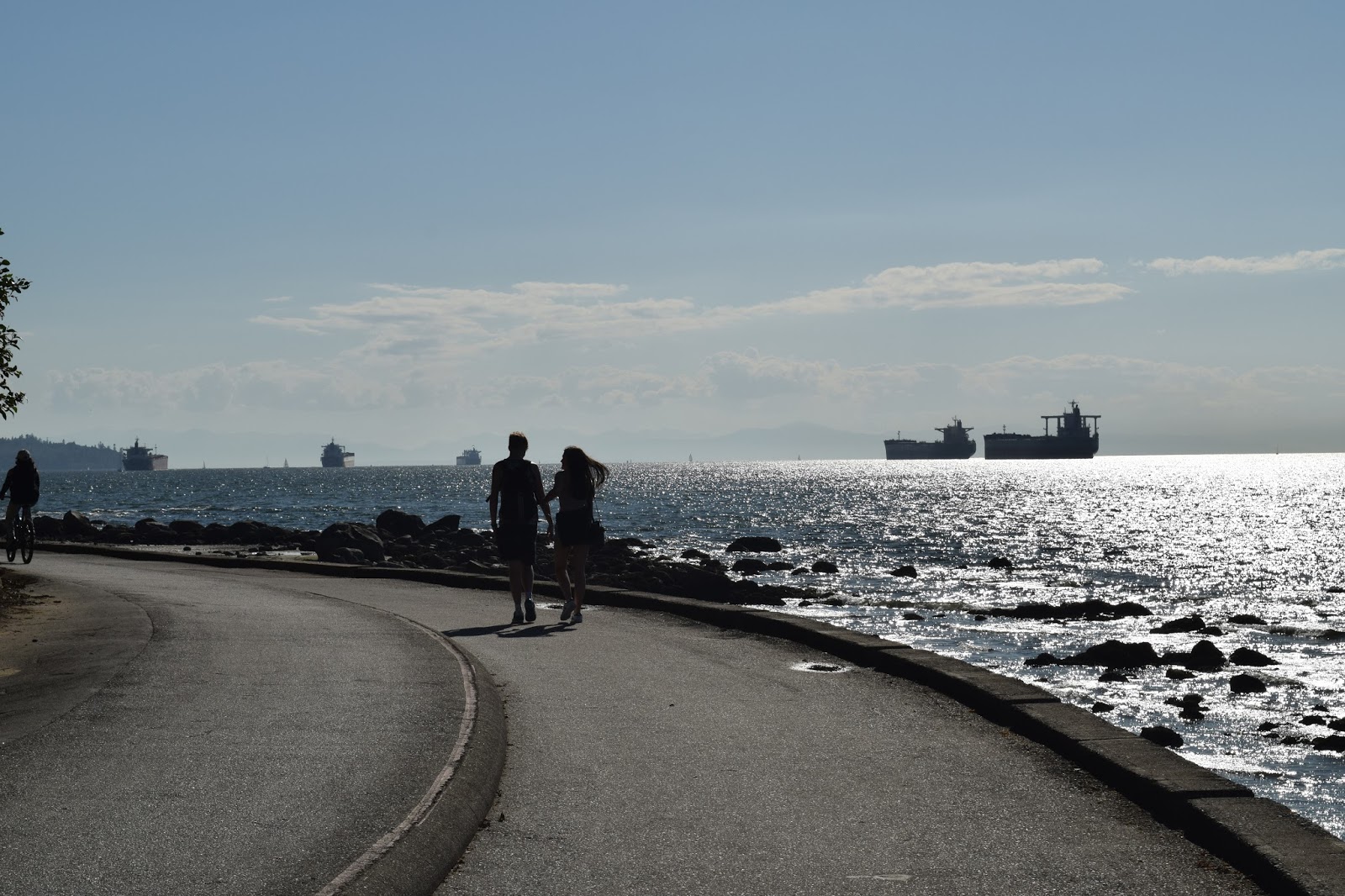
On the sea wall the path was heaving with walkers, cyclists and roller skaters.  The horse drawn wagons were doing a brisk trade too - I imagine this is a lovely way to see the shoreline road.  Our view across the water was to downtown Vancouver with its skyscrapers gleaming in the afternoon sun.  There were plenty of yachts in the harbour completing the scene.  We decided to head anti-clockwise around the trail - this seems to be convention and certainly the way that cars on the shoreline road take on a one-way route.

Horse Drawn
The first point of interest along the way was the Totem Park - a fantastic display of totem poles that also acted as a honey pot for many of the tourists visiting today.  None of the poles are especially old - most have been carved in the last 50 years.  The intricacies of the designs and the unique nature of this form of artwork deserved some time to look at properly and we paused here for quite a while.  Off to one side was a bronze piece called Shore to Shore, a sculpture commemorating the ancestral connection between the indigenous people and the Portuguese settlers.  This was perhaps the most fascinating of all the pieces and we enjoyed reading the back story behind the sculpture.

Lion's Gate from Brockton Point
The seawall walk continued eastwards and we overlooked the Canada Pavilion, built for Expo 86, the World Trade Fair that I visited on my first trip to Vancouver.  It now acts as a cruise ship terminal and two ships were docked - one was the Sun Princess and the other the Celebrity Millennium.  It got us quite excited for we were due to go on a cruise in a few days time on a different Princess ship.  This particular one is a sister ship to the Sea Princess, which hit the headlines a few weeks later when two of her passengers were arrested for drug running!

Angry Wasp
We passed the Nine O'Clock gun named for obvious reasons.  The gun has been around for some time, originally cast during George III's reign in 1816 and brought over to Vancouver in 1894. It was rather smaller than I imagined, but then I suppose if it were much bigger it might cause some damage with its alarm.  As we passed by I became aware of a seaplane about to take off.  This was the first of many that we saw on our walk - there is a very regular (if a little expensive) service to Vancouver Island.  I imagine this is pretty well used by those that need to do the journey to the provincial capital Victoria quickly.  The plane made a noise rather like an angry wasp as it disappeared over the water to its destination.

Girl in a Wetsuit
Just past the gun and the shoreline changed direction, briefly heading north to Brockton Point.  We got a great view down the Fraser River, which reaches the sea in Vancouver after a tortuous route from the distant Canadian Rockies.  It has carved quite a gash through the landscape and it is no surprise to see how big it is at its mouth.  At Brockton Point we passed by the small lighthouse warning shipping of the danger that this rock poses.  The path continued along the north shore of the park and past the Totem Park once again.  The distance from north shore to south shore at this point is only a matter of tens of metres.  What was remarkable though was how soon we seemed to lose the crowds - few seemed to continue after the totem poles and accompanying gift shop.

Empress of Japan
Our view changed markedly too in these few metres.  We had swapped our Downtown view for one across to North Vancouver and Grouse Mountain beyond (where we had spent the first part of the day).  In the far distance was the enormous Lions Gate Bride, the impressive structure that takes traffic from Downtown to North and West Vancouver across the Fraser River.  Our walk was now in shade too, a welcome relief after the heat of the south shore.

Celebrity Millennium
This part of the walk was very pleasant and quieter.  We passed by a children's play area that was very well equipped and fairly busy but otherwise our attention was mostly on the water.  As we wandered along two large ships passed by - the first a container ship loaded to the gunnels and possibly heading out across the Pacific Ocean to the Far East.  Much of Vancouver's trade heads in that direction.  Not long after the Celebrity Millennium headed out on its cruise, most likely to Alaska.  As they passed we passed by Girl in a Wetsuit, a play on the mermaid sculpture that famously guards the sea in Copenhagen.  This one has been here since 1992 and isn't so famous...

Lion's Gate Bridge
Even more eye catching further ahead was the figurehead from the RMS Empress of Japan, once known as the 'Queen of the Pacific' and was the fastest ship across the Pacific.  She was built in 1890 and continued in service until the 1920s when she was withdrawn from service.  Some of her interior fittings found their way into local homes but the figurehead was rescued from the scrapheap by the local newspaper and put on display here.  The one on display now is not the original but a replica - the original is in the City's Maritime Museum.


Prospect Point
We decided to carry on as far as Lions Gate Bridge and then cut up through the park due to the temperature and the distance back.  However what we didn't reckon on were the high cliffs on the other side of the bridge, which precluded any trip inland.  I'm not sure any of us were too disappointed for the walk was to take on a rather different dimension now.  The bridge seemed to mark a turning point - the coast was now less river and more sea as we looked out across more expansive water to Vancouver Island in the distance.  Lions Gate Bridge looked particularly impressive from below - the rumble of cars overhead reminded us what an important artery this is.  The bridge was built in 1938 and the decks were completely replaced about 15 years ago.  It is high enough that even the biggest ships can pass underneath comfortably.

Siwash Rock
Having passed the bridge we now had the seawall pretty much to ourselves save for the most intrepid runner (and there were a few of them - I imagine the whole sea wall is on their regular routes).  The cliffs on the shore side of the sea wall were impenetrable for quite some time - in fact well past Siwash Rock.  This eye-catching feature is unusual - in fact it is the only stack offshore at Stanley Park.  Made of basalt it is rather more resistant to wave action than the surrounding sandstone.  It is adorned by a bit of shrubbery at the top and despite looking very inviting to climb there a number of signs warning people not to.  I guess the chances of accidents are pretty high but also the stack looked like it could be fragile if attacked too many times by enthusiastic climbers.

Approaching Third Beach
Shortly after passing the rock and we passed by Third Beach.  I never really took Vancouver for being a beach kind of place but this one was certainly very popular with planty of bodies laying out enjoying the heat of the sun.  Not everyone was wearing clothes either - not something I expected to see in North America!  We considered turning inland here but by now we had walked enough of the wall to continue all the way down to Second Beach.  We rounded Ferguson Point and looped around the next bay when the Downtown skyscrapers came into sight once again.  This was probably the quietest stretch of the whole walk - no doubt most people that had walked along this stretch were now lounging on the beach!

Third Beach
At Second Beach is a large outdoor swimming pool that had more than a few customers.  The thought of having a dip was quite appealing but sadly we hadn't brought any swimming stuff and so had to push on.  By now we were ready to cut across the southern boundary of the park to rendezvous with our starting point.  We took the route along the southern shore of Lost Lagoon.  I assumed this was a natural feature but was rather surprised to learn that it is man made.  Apparently it was constructed when the road to Lion's Gate Bridge was built across a causeway and cutting off what had originally been a continuation of Burrard Inlet.  The landscaping of the lake was top notch for now it is a popular place for birdwatchers who come to see the variety of life that the lake supports.

Doomed
As we wandered along the path here the distance and the heat were beginning to catch up with us.  I felt hotter when I saw what a chap in front of us was wearing - he looked pretty disheveled and was buttonholing people that he passed.  I quickly realised that he was a religious zealot so gave him a wide berth - hapless passers by weren't so lucky.

Black Squirrel
We soon came to the main road that bisects the park and went underneath via a subway.  This was less grand than the Lion's Gate Bridge that we had passed under on the other side of the park but the effect was the same - it was a relief to not have to deal with the traffic.  Immediately we were back on the shore of Coal Harbour and from here it was a short distance back to the car and completion of the walk.  We felt a little relieved to have made it and some cold drinks at the end certainly were very welcome.  In truth this is not a hard walk but I'm not sure I would want to do it again on such a hot day.  For a walk around an urban park though this surely cannot be beaten.  If you are in Vancouver give yourself enough time to do it yourself - you won't be disappointed!


Coal Harbour

Tuesday 25 October 2016

Whatcom Falls

Whatcom Falls
The third of my walks in Bellingham and another old favourite - the three mile round trip of Whatcom Falls Park.  This park is yet another of Bellingham's gems and as with the South Bay Trail an old railroad plays a part.  We parked up in the main car park and headed down the hill to find the old stone bridge that is perhaps the most famous feature of the park (maybe even more than the falls after which the park takes its name).  The park itself started life in the early 1900s and was quite well established by the mid 1930s when the bridge was built.  It was funded from the Roosevelt programme to get the country moving during the Depression.  The Chuckanut sandstone was mostly provided from a burnt out building downtown.  The fish hatchery next to the bridge was built around the same time from the same funding source.

Whirlpool
On this hot summer's day the Falls were rather non-descript as the river level was so low.  The creek can be pretty full of water especially when the flow is being regulated by flood defence needs at Lake Whatcom, about a mile upstream.  Being low had its uses though - it was far easier for children to paddle in; a very useful attribute on this hot day.

Railroad Track
After crossing the stone bridge we headed downstream on the path high above the water level.  The steep sided valley of Whatcom Creek means that it isn't too easy for the path to stay close to the river side.  The shade of the trees was very pleasant for our walk and the sound of birds vied with the sound of the rushing water below.  We passed by a space in the trees which looked rather unusual.  I remembered that this was where the Whatcom Falls disaster happened.  In 1999 a buried pipeline burst, spilling 200,000 gallons of gasoline into the valley.  The inevitable happened and it caught fire, creating a fireball that was to sadly claim the lives of three young people who were in the park at the time.  The burn area is healing now but the scars to the landscape can still be seen.

Trestle
Further on and we came to the Whirlpool.  This deep part of the creek as it turns the corner is a favourite place for youngsters jumping in for a cool off and so it proved today.  There were throngs of teenagers jumping from higher points than seemed wise but they all seemed to know what they were doing.  Laughing and shouting was the order of the day and it was great to hear so many people enjoying themselves.

Trestle
We climbed up and away from the whirlpool and up to one of the many railroad trails that exist in the city.  There was a time when railroad was by far the easiest way to move materials around, especially lumber.  The line that came up through the park was built by the Chicago, Milwaukee, St Paul and Pacific Railway in 1916 and linked Bellingham Bay with Larson's Mill nearby.  We walked alonmg the trackbed for a short distance when our way was blocked by the severing of the trestle that once took the railroad across the creek below.  The twisted rails of the old railroad are still evident but there is a safe distance between the end of the embankment and the former tracks so dissuade anyone from exploring further.  The railroad has been closed for more than 50 years but a section lives on at the other end of Lake Whatcom, operated as a heritage railway by a group of enthusiasts.

Whatcom Creek
Our onward path was via another railroad trackbed for the short distance towards Bloedel Donovan Park, a small park across the road that is on the site of a former lumber mill (and presumably a big customer of the railroad).  We didn't cross to the park but instead double backed down Whatcom Creek towards the car park.  I don't remember this path from the last time I came here - in fact much of this end of the park seemed new to me.  The path went down the backs of houses that are located along Electric Avenue.  The gardens were mostly immaculate and rather a joy to see over the fences!

Whatcom Pool
As we headed downstream the creek got wider until it reached a bend.  By here a large pond like pool had formed and curiously this area is available for fishing, so long as you are under 14 years old!  We didn't see any takers - presumably they were all having fun at the whirlpool even further downstream.  We stopped to enjoy the scene for a moment.  Having strolls rather than proper hikes allows you to do this!

Whatcom Pool
At the far end of the pool we crossed the low bridge that disguises a small dam.  This is from the time when the water treatment works was near here and water was taken away from the river for treatment.  Drinking water is still extracted from Lake Whatcom but treatment is elsewhere now and the original treatment house is an oddity in the park closed to where we left our car.
Black Squirrel

Crossing the bridge here wasn't really necessary as we could easily have found our way back to the car on the same side of the creek.  However, by crossing the bridge we got to see a black squirrel and a crazy lady who told us all about the wildlife she had seen over the last few months.  She was pretty harmless but full of enthusiasm and wild hair :)  Black squirrels are pretty common in these parts now - they have rather moved in over the last few years and stolen the territory of the grey ones.  I think they are actually a different variety of the same species.
Fungus

For my children though the main benefit to crossing the river by the bridge was that we had to recross it further downstream using whatever stepping stones we could find - it proved quite a fun activity!  On the other side we passed the hatchery that was built at the same time as the other features of the park.  It was empty and devoid of life - I wasn't sure if this was a permanent thing or it was just the wrong time of year.  It had rather a melancholy feel about it in any event.  It marked the end of our walk and while I thought we might be talking about the life cycle of salmon the children were more intent in checking out the play area!

Crossing Whatcom Creek
This might be a walk modest in length but it is packed full of interest and worth a look even if you are only passing through Bellingham.  I shall certainly be visiting the next time I come!

Former Treatment Plant


Sunday 16 October 2016

Lake Padden

Padden Clouds
Continuing my short series of favourite walks in the Bellingham area we simply had to make a trip to Lake Padden.  In fact this is the one park that I have never failed to visit on any of my trips to Washington State.  Lake Padden was once the water source for Bellingham until the city grew much larger and the bigger Lake Whatcom was used instead.  The area was incorporated as a park in 1972 and is something of a playground for local residents, with picnic areas and sporting facilities available as well.  There is also a lengthy trail network, particularly in the surprisingly wild part of the park on the south shore.

Relaxation
This walk is restricted to the 2.6 mile shore path rather than straying into the wider network of paths, but to be fair you will get a sense of what the park is about by following this trail.  Adding extra mileage will do more for your health but you won't see anything more than extra forest.  We started our walk at the main car park off Samish Way.  If you are feeling really energetic it is also possible to walk here from Fairhaven via Padden Gorge.

Lighting the Leaves
It was a glorious Monday morning - in fact I cannot think of a better activity for a Monday morning!  It sure beat the normal routine of getting ourselves to school and work :)  We walked anti-clockwise around the shore trail.  I'm not sure why but we tend to walk in that direction, for no other reason than it just feels right.

Forest Section
Almost immediately we could see some of the leisure uses of the lake.  Some youngsters were lolling around on the bank and I hope were taking turns in the hammock they had strung up between two trees a little further on.  A couple of fishermen were trying their luck on the banks and plenty of other people were also out walking and running the shoreline trail.  The beauty of walking in this direction was that we were soon in the shade of the forest.  While the north shore is dedicated to sports and leisure activities the south shore has largely been left alone and the path walks through some beautiful old growth forest.

Softball Pitch
We first stopped at the dock so that we could admire the reflections of the puffy clouds appearing in the surface of the lake.  We tried not to disturb the fisherman at the end who was trying his luck.  Given the amount of effort he was putting in and the amount of equipment he had I'm not altogether sure that he was really there to catch fish - more to enjoy his surroundings with the fishing rod as his excuse.

Lilies
From the dock the path takes an undulating walk through the forest.  At times the walk can be quite dark and the shade was very welcome on this very hot day.  Every now and again the light penetrated through as a fallen tree had provided a gap in the canopy.  The forest was alive with moss, insects and even the odd fungi but strangely no sign of any wildlife or even birds.  Mind you, the incessant chatter from my girls didn't help on that front!

Lake View From the East
The forested section of the walk is approximately a mile and at the far end of the lake where you expect to continue around the shore the path continues straight on a bit further to dog leg around the lowest bridging point of the inlet creek.  I have always thought this part of the trail a bit of a nuisance especially as you have to double back along the opposite bank (this isn't necessary if you emerge from the lengthier extra walk through the forest.

Dock
On the right hand side of the path the first of the sports piches can be seen and today there was a small group of youngsters testing their softball skills.  Further beyond this and rather out of sight is a golf course (safely away from prying eyes!).  On the shore of the lake we could see other families getting ready for barbecues and picnics.  It was pretty obviously school holidays judging by the activity in the park.  Rather surprisingly though it was confined to a pretty small area around the play area and the sports pitches.  We were soon back in a quiet part of the park and heading through more woodland although this time more managed.  We also passed by what looked like an old building that I iamgine was something to do with the water extraction that took place here.  Funny thing is I've been up here dozens of times and never noticed it before.  How weird is that?


Car Park View
We were soon back at the car and ready for a spot of lunch.  I could easily have done another lap it was that nice of a day :)

Monday 10 October 2016

South Bay Trail

Boulevard Park
We spent our summer in what I consider to be my second home of Bellingham in Washington State.  It has been far too long since I managed to make the trip across to the city where my wife was born and grew up.  We arrived to something of a heatwave and so despite our best intentions of some lengthy hikes while we were there it actually proved not to be possible due to time contraints and weather conditions.  We focused instead on the old favourite short walks around the city and surrounding area.
Autumn tints

Bellingham is a city situated approximately 90 miles north of Seattle and 50 miles south of Vancouver.  It is blessed with a fine network of walking and cycling trails, many of which follow former transport routes.  This particular walk follows the former interurban railway route between Fairhaven on the south side of the present city and the downtown area of Bellingham.  Once these were two distinct places and the railway was a valuable connection between the two.  There is a present day railway but there is no longer a passenger service that connects Bellingham with Fairhaven.  The next stop north on the Amtrak service is Vancouver on a service that runs only twice per day.
Downtown View

The interurban railway connected Bellingham with Mount Vernon and was opened in 1912 during the boom time for these railways.  By 1915 there were over 15000 miles of interurban railways in the USA and they were primarily used for passenger travel between neighbouring cities, often linked to streetcar networks and usually electrically powered using 500-600 volt DC systems.  Most were short-lived and this particular route was shut in 1930 after a couple of accidents further down the line.  The first involved one of the cars derailing on a curve and tumbling down an embankment while the next only a few months later happened when a train smashed into a rock that had fallen on to the track.  The result was pretty much the same although it was a miracle that no-one died in either incident.  As far as the future of the line was concerned these two accidents pretty much cooked its goose.
South Bay Trail

A lengthy stretch of the trackbed between Fairhaven and Larrabee State Park is preserved as a foot and cycle path and although I have walked it a few times in the past I am going to focus this time on the short stretch that ran between Fairhaven and Bellingham for this trail is remarkable in its reconstruction of the former line for this two mile stretch.  When I lived in these parts in 1995-96 I was only vaguely aware that there was a second railway built on trestles out in Bellingham Bay but in 2007 the City rebuilt a lengthy portion of it, not in wood this time but in concrete.  The use of material was probably a smart move as the original trestles suffered from saltwater worms having a liking for it and constantly attacking it.

Boardwalk
The trail starts in an alley leading off from Chestnut Street close to a Wood Fired Pizza outlet.  I suspect that the original route followed the line of Railroad Avenue although this doesn't quite connect with the beginning of the trail on a trestle just behind the Bellingham Farmer's Market.  This section is the oldest part of the route - I remember walking this section in the mid 1990s.  What I don't remember though is the line of condos that have appeared alongside the trail - it certainly has a different feel with the buildings cheek by jowl with the path.  Soon a road is reached and the path crosses Wharf Street obliquely before continuing its SW course.
Boardwalk

This section of the path is fairly closed in feeling a little isolated from the wider environment.  It follows a green line that runs below the coastal road of State Street and above the route of the Burlington Northern Sante Fe railway that runs along the shore below.  Eventually I would meet the present day railway as the trail runs steadily downhill to shore level.  Signs of autumn were already showing even though I completed the route in early August.

Alaska Ferry
I have walked this route a number of times and have never had to wait for a train at the bottom.  Today was no exception and I wandered across the track at the pedestrian crossing.  I do remember that it was almost accepted that people wandered along the track in the old days - signage now suggests that this practice is no longer tolerated.

Boundary Stone
On the other side is Boulevard Park - one of the gems of Bellingham and with wide ranging views out across Bellingham Bay and Lummi Island beyond, what is not to like?  Certainly the locals flock to this place - it is always heaving with people at the weekends and on summer evenings as locals come down here to have their barbecues.  With magical sunsets over the water it is easy to see why so many people come.  I walked around the park people watching as I went.  It is a fascinating place - people playing sports, doing Tai Chi or generally sitting around and nattering.

Fairhaven Mural
At the far end I passed by the small coffee shop (worth a halfway stop if you get thirsty). and I passed over the first section of boardwalk - this straight section was in place when I first visited and lived in Bellingham in the mid 1990s.  On the other side though walkers had to cross the railroad tracks diagonally to continue walking on into Fairhaven.  Since the onward trestle was completed in 2007 the way forward is a lot more pleasing.  The arc of the trestle follows roughly the line of the former interurban railroad but it suddenly stops.  I suspect that the money ran out at this point, or perhaps reaching landfall at the more logical end of the route was too difficult because of the proximity of the BNSF railroad?  Anyhow the route suddenly heads back to shore via a ramp up and over the railroad and the route continues through some backroads to Fairhaven.  On the day I walked this section the ferry to Alaska was in - quite an adventure to travel on this up the Inside Passage to Ketchikan and Skagway.
Fairhaven Village

Fairhaven is a pretty good place to wander around with a lot of interesting independent shops and a smattering of restaurants.  It is worth wandering around enjoying the ambience of the place before either heading back downtown via one of the frequent buses.  If you are feeling particularly energetic you can complete the whole of the former Interurban Trail by continuing along the trail that runs up Padden Creek to join the onward route to Larrabee State Park.  Just be aware there is no public transport that can bring you back and it is a 12 mile round trip (not a problem on a bike!).  It is also possible to link this walk with an exploration of Lake Padden.  It is there that we shall be headed next.

Fairhaven