|
| Chapman's Pool |
This is another part of the coast where public transport is scarce so I had to be creative with how I broke up the sections. This led to the rather contrived start point for this walk, using Kingston village (about a mile and a half inland) as a starting point. I parked in the village, leaving the bus journey for last. This wasn't too much of a problem for there is an hourly service from Swanage. It promised to be another hot day during the heatwave that is summer 2018 and I had made sure that I was very well stocked with stuff for there are no places to resupply along this route until almost at Swanage.
 |
| This way |
The walk down from Kingston village is easy - just follow the road down from the church that eventually becomes a farm track. It is pretty much downhill all the way from the village to the coast. When I hit the coast finally it was at the top of Houns-tout Cliff and down I had to go once again this time down a very steep slope to just above Chapman's Pool far below. Now reunited with the path I had to take a rather convoluted route inland a bit to a place where I could cross the valley easily but a cluster of very attractive houses. This route has changed in recent years because of the unstable nature of the cliffs, rendering the original route unusable. On the other side I had to practically double back to climb the slope of West Hill (on the eastern side of the valley!).
 |
| Emmett's Hill Memorial |
Once I had slogged to the top I got one of the best views on the whole of the South West Coast Path across the turquoise water of Chapman's Pool and the chalky landscape of the Purbeck coast towards Lulworth. The familiar shape of the Isle of Portland loomed on the horizon, the last part of the coast going eastwards that it is possible to see it. The path along West Hill and then Emmett's Hill is a delight - level walking for about half a mile with superb views all the way out on the right hand side. As I walked along this stretch of route I became aware of large groups of walkers both ahead and behind me. From a distance they looked like school groups and my heart sank. My peace and quiet for the day would shattered. For now I enjoyed the fact that they were some distance ahead and some distance behind.
 |
| St Aldhelm's Chapel |
Along the level part of Emmett's Hill I came upon a memorial to the Royal Marines. This was originally put here in 1989 to commemorate the atrocity at Deal when the barracks there was blown up by an IRA bomb attack. The memorial was commissioned by the Poole Branch of the Royal Marine Association and they wanted a site that looked out over the wild coastline. I'd say that this location fits the bill perfectly! It was beautifully planted with poppies and other flowers and looked very well kept despite its relatively remote location. I lingered for a short while before pushing on towards St Aldhelm's Head.
 |
| Radar Research Memorial |
Soon my nice level path came to an abrupt end just shy of the headland as it plunged down into a deep valley. I decided to stop at the bench at the top for some refreshment especially as I seemed to be catching the group up in front. I noticed for the first time now that they weren't school groups but adults all wearing the same T-shirts. While I was trying to decide what was going on a couple from the same event came past and I could then see that they were all on a charity sponsored walk. I was most surprised to learn that they were actually supporting a hospice nearby where I live and not a local one at all. They were walking from Corfe Castle to Bournemouth, a tidy step at 30 miles especially on such a warm day.
 |
| Dancing Ledge |
I walked with them on and off for a couple of miles, a rare experience for me. Mostly small talk and after awhile I got the sense that they wanted to continue talking without me so we wished each other well and walked at our own pace. At St Aldhelm's Head I passed by the small Norman chapel which looked rather incongruous in this exposed location not near any other housing. I guess you would have had to be rather pious to make your way up here! It is likely that the chapel also doubled up as a daymark for passing ships, a use that has long since been outdated. Just by the chapel is a watch tower of a different sort - the National Coastwatch station. The chaps inside were pretty dedicated to their watching and paid no attention to me.
 |
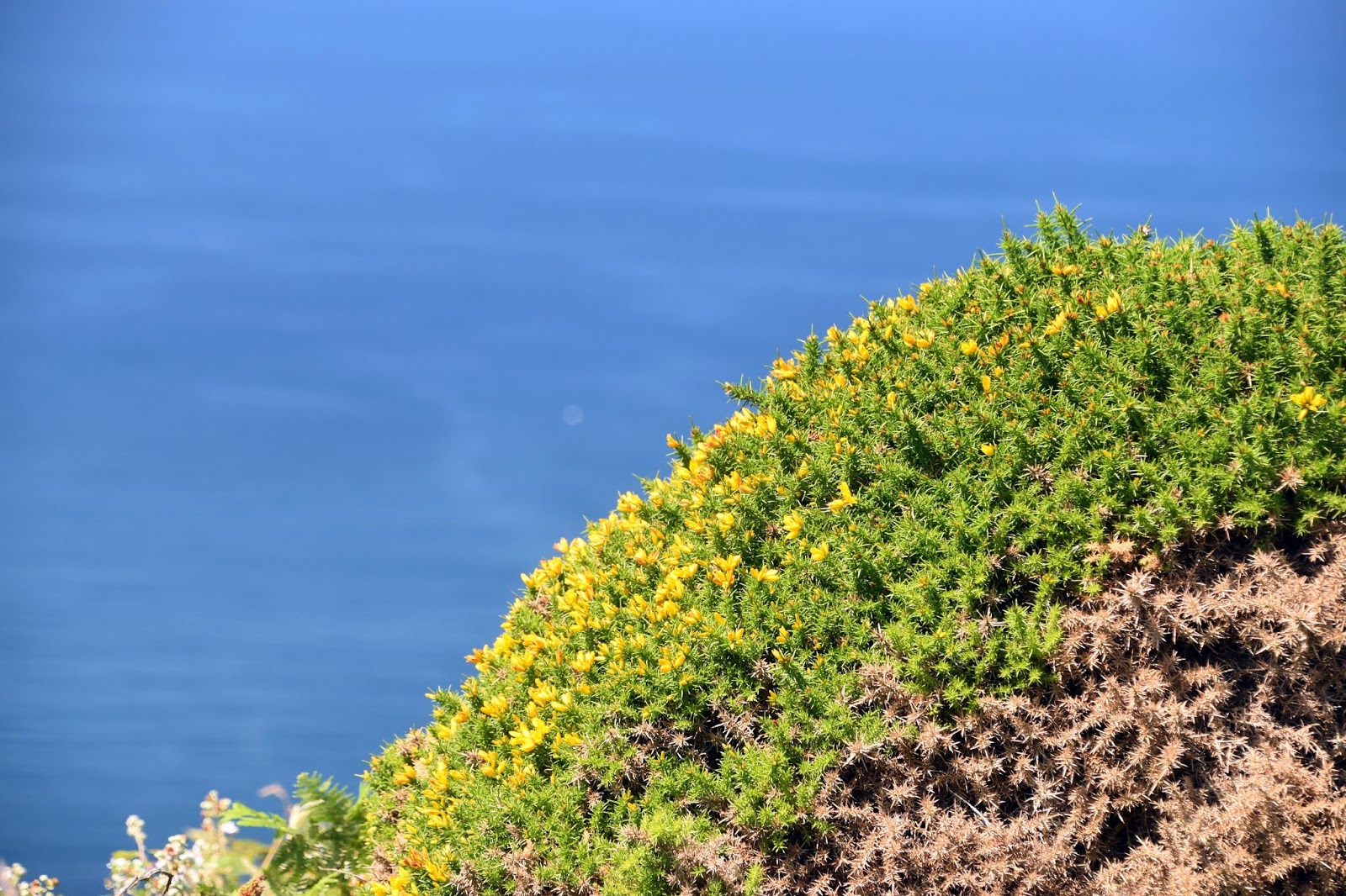
| Jurassic Coast |
The section of coast that followed was reminiscent of the coastline of the Isle of Portland and even had a number of quarries along the cliff line; all long since out of production. They did make for interesting industrial archaeology sites although nature is doing its best to reclaim them. Most of the quarries were now filled with wildflowers and red valerian, that cheerful looking invader that seems to love our coastline. From St Aldhelm's Head to Dancing Ledge the going was very easy - far more so than I have been used to on the coast path in recent years. Of course the fact that I was walking on my beloved chalk helped considerably. It was like walking the South Downs!
 |
| Climbing Groups |
At Dancing Ledge there was a large school group doing some kind of climbing activity that also including being in the water. I imagine the children were thankful for the seawater as it was now building into a very hot day. I also noticed a small cannon protecting the coast and later when I returned I looked it up as it did seem like an unusual place to put one. Apparently it was lost from a ship called Halswell that was sailing to India when it was caught in a storm and wrecked just offshore here. Not long past Dancing Ledge I seemed to threaten the pace of the very large group ahead of me so I slowed a bit so I wouldn't catch them up.
 |
| Anvil Point Lighthouse |
The path eastwards to Durlston lighthouse was fairly featureless and I managed to walk this section very quickly. I paused at the lighthouse - it did look very good against the powder blue sky. By now I was joined by lots of other visitors and not just the sponsored walkers. This is because the lighthouse is at the edge of Durlston Country Park, one of the main attractions of Swanage. There was significant evidence of more quarrying here in the shape of Tilly Whim caves. This name appears to come from a quarryman called Tilly who worked here in the 1700s and Whim was an old crane that did the work of loading the stone onto ships. Apparently the caves were once open to the public but are now closed as there were a number of rock falls in the 1970s.
 |
| Anvil Point Lighthouse |
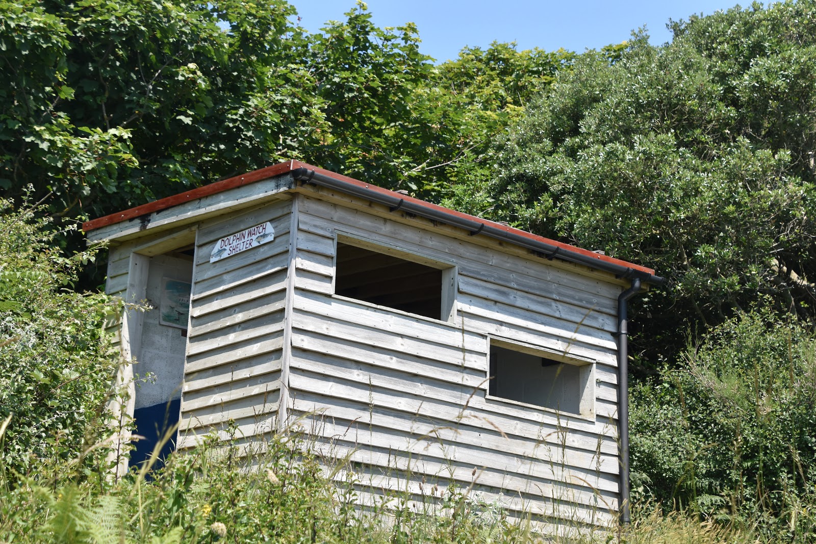
Just up from the caves is what I initially took to be a bird hide but in fact has a rather different function - this small shed with viewing is actually for watching dolphins. Knowing that I wasn't blessed with a lot of time and that I would need a lot of patience to see any dolphins I decided not to linger but pushed onto the 'castle' at the heart of Durlston Country Park instead.
 |
| Dolphin Watch |
The castle was built by George Burt, nephew of the founder of Mowlem (the large building company). Much of the park features architectural salvage from some of the construction projects he was engaged on. At the heart of it is the castle that was actually (and still is) a restaurant to cater for the visitors to the park. The whole place is now owned by Dorset County Council rather than the Mowlem/ Burt family. Nonetheless it did make for a very welcome watering hole and I quickly drained an ice cold pop.
 |
| Red Valerian |
My way onwards from the park was through a wooded area, which was very welcome as the heat had really built during the morning. There were peepholes through the trees every so often to see the view beyond and for the first time it was possible to see the Isle of Wight - it almost felt like home territory as I can see the Isle of Wight (albeit the other side) from Worthing! The path then wound around the end of the park before I had to climb up and out into a housing estate, passing an amazing looking yew tree on the way.
 |
| Descent Into Swanage |
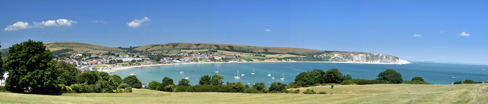
I came out into the light blinking from the powerful sunshine and was pleased that the stretch through the housing estate was pretty short lived. I turned right along a path that had been adapted for wheelchair use and this led down into Swanage, my destination for the day. As I got lower down the slope the magnificent situation for the town came into view; for my money this small seaside town has one of the best backdrops of any town anywhere in the UK. It was also surprising to look back at Durston Country Park - I inadvertantly walked a long way without even realising it!
 |
| Swanage Vista |
I soon found the main road into Swanage and wandered along into the centre of town. I have to confess the smell of fish and chips soon got up my nose and I just had to have some. Somthing about the sea air I suppose! Despite the fact that it was a school day the beach was surprisingly busy and I sat on the promenade wall scoffing my chips and watching the families on the beach with some amusement. I couldn't help but think that the coastline was already giving way to a holiday coast rather than the rugged one I have been walking all these years. Only a short hop from here and I would be seeing the end of the walk at South Haven Point. That remains for another day though...
 |
| Swanage Beach |