Saturday, 14 August 2010

Peak Forest Canal Whaley Bridge - Bugsworth Basin


Pride of the Peak
A favourite haunt of mine when I lived in this part of the country was the towpath walk along the Peak Forest Canal.  This arm of the canal system reached right into the western edges of the Peak District until it was no longer practical to build a canal any further on account of the terrain.  From here horse drawn tramways would take over, allowing precious limestone and other mined materials to be shipped into Manchester and other industrial cities to be used as building materials and feed various industrial processes.  The canal closed in the 1920s for this use but is largely now used as a leisure canal with plenty of boat traffic still able to use it.  More information can be found at http://www.penninewaterways.co.uk/peak/ along with a nice photo gallery of the remaining part of the canal.
Whaley Bridge
Although I had walked along many different sections of the tow path I had never before walked along the short stretch from Whaley Bridge, or local town for the duration of our stay, to Bugsworth Basin.  These two places on the canal were extremely important for both had canal basins that were used as the transfer points for materials from rail to canal barge.  In the case of the basin at Whaley Bridge the canal basin formed an integral part of the trans-Pennine canal system since it was connected to the East Midlands canal system via the curious Cromford and High Peak Railway Line (http://en.wikipedia.org/wiki/Cromford_and_High_Peak_Railway).
Green Bridge
The two canal basins are actually quite close together (only about a mile or so) and I thought that it would be a trail full of interest for my children.  My oldest daughter in particular is lapping up history as well as nature and I was certain that the walk would fulfill both sets of interests.  It’s a walk that’s much shorter than any that I normally include on here, being little more than a stroll, but it was notable for being the first that I have included the whole family on, and eventually I hope to explore the whole transport corridor that crossed the Peaks, including the rest of the canal and the tramway. 
Bugsworth Basin
We started at Whaley Bridge and wandered past the brightly coloured canal boats moored along the short arm of the canal that serves the basin.  The girls were fascinated by their decoration and took the opportunity to shout hello to one or two passing boats.
Bugsworth Basin
Otherwise it was running, running, running to explore what was round the corner.  We soon reached the junction with the main channel of the canal and had to cross via a fairly flimsy looking footbridge.  The left hand turn of the channel continues towards Marple and Ashton-Under-Lyne, meeting with the Macclesfield Canal a few miles away and would have represented the main outlet for goods travelling from Whaley Bridge.  The remaining part of the walk to Bugsworth Canal Basin was a feast of sights and points of interest for the children.  We saw more canal boats that seemed to be lived in on a more or less permanent basis (albeit moored temporarily) with all manner of decoration on them including gardens in some cases.  Sadly not all the boats were in very good condition and although the idea of travelling around by waterway really appeals to me, the hassle and expense of maintaining one of these boats would be a major obstacle for me.  Towpath walking is probably just as enjoyable!  Shortly after turning onto the Bugsworth Arm we passed underneath the A6, which apparently would have subsumed the canal entirely if road planners had got their way when the Chapel-en-le-Frith and Whaley by-pass was built.  It was this threat that finally encouraged local people to preserve Bugsworth Basin for everyone to enjoy.
Domestic Bliss
The next bridge was rather different and fascinated my daughter; it was a pipeline bridge that was covered in clematis, slowly inching its way across the canal and getting bushier and bushier.  I suppose for now it looks quite attractive but eventually someone will have to prune it before it gets out of hand!  Just past here were the canal workers' cottages, which look like very desirable residences these days, with a ready made cycle path outside to Whaley Bridge station if you wanted to commute somewhere else for work.  We also passed a smallholding with a couple of very curious geese intent on making sure we didn’t come any closer.  The pig behind didn’t seem to care too much about us; it was too busy making a lot of noise as it rooted around in the mud.  Eventually we arrived at the gauging station where the boats were checked to ensure they were not overloaded.  This was characterised by a narrowing of the channel, where the water level was measured to work out the toll payable for its journey.  The boat would have a set of plates fitted to it, which would then be measured for their height above the water and compared with previously calibrated measurements from known weights.  In this way the toll-keeper would know how much money to collect the money for using the canal.
Back to Whaley Bridge
We then entered the amazing world of Bugsworth Basin and could immediately see how much work had been done to restore the old place.  Derelict for many decades the whole basin has recently been restored and can now be used by boats again.  Nowadays it forms an attractive place to moor rather than be a loading point for goods so is a lot quieter than it once would have been.  We had a good look around and showed the girls the model of what it would once have looked like when in its heyday.  All that remains of the ongoing tramway from here is the stone sleepers (no wood in those days!).  It is perfectly possibly though to imagine how the place would once have looked, although thankfully now we do not have to endure the smoke of the lime kilns or the din of the crushing plants.  As an industrial complex the set up isn’t so far removed from the loading station at Eurotunnel in Folkestone (on a much smaller scale of course).
Former Wharf
By now the children were getting pretty tired and so we headed back to Whaley Bridge.  It is possible to walk along the trackbed of the Peak Forest tramway, which would have brought the limestone from quarries another 10 miles further into the Peak District.  This would have to wait for another day though as it would have been a further four miles to walk to the end of the available section and back.  I decided that I would take a closer look at Whaley Bridge canal basin instead by walking ahead and arranging to meet the rest of the family at Tesco (right by the end of the canal in Whaley Bridge).
Cromford and High Peak Line

Whaley Bridge basin was a lot smaller and less busy than Bugsworth and acted as the transfer point for goods between the Cromford and High Peak Railway that snaked its way across the limestone plateau of the Peak District and connected the canal systems of the East Midlands and the North West.  I first became interested in this railway when I was a kid and read a book about industrial archaeology, which heavily featured the railway and canal basins because they are remarkably well-preserved.  The wharf building at Whaley Bridge is in great condition and looks like it is used as a canal barge workshop these days (although the doors were completely shut).  Despite being in the town centre the first part of the old railway can also be traced past the car park and across a bridge that spans the River Goyt.  Remarkably the old bridge still has tracks embedded in the paving and the narrowness of the bridge can be appreciated.  The Cromford Railway was characterised by steep inclines to gain height over the limestone plateau and the first of these is just beyond the bridge.  It must have been a fascinating sight watching trucks being hauled up and down these slopes.  Unusually the one at Whaley Bridge was apparently hauled by a horse-powered engine right up until closure in 1952.  From here the railway would once have threaded its way along the Goyt Valley, gaining height on several more inclined planes before getting to the summit of Ladmanlow, about eight miles south of this point.  Some time I will take a look at what remains of the line, which is complete for much of its length.  However, today this teaser for a future visit was all I had time for.
Whaley Bridge Incline

This was definitely an appetiser for a look at what is a fascinating insight into our industrial past that’s even older than most closed railways I have walked along.  The rest of the canal and associated tramways beckon for a future visit!

Monday, 9 August 2010

1066 Country Walk Section 2 Boreham Street - Battle

Boreham Street
After a false start on this walk a couple of weeks earlier (we forgot the map, so had to retrace the first section in reverse!) my wife and I managed to find another spare day without children (both were at school) to undertake the eight miles between Boreham Street and Battle.  As with the last section of the walk public transport would be a bit convoluted so we parked at Bexhill station and took the bus over to Boreham Street.  Being a Tuesday the village was deserted when we got off the bus, the only sign of life being the cars travelling through at great speed.  If I’m honest the road rather spoils the appearance of the village, which would otherwise be a very pleasant and peaceful place.
Which Way?

We wandered along the road to the eastern edge of the village and were quite pleased when we crossed the fence and entered open countryside at last.  Since our last trip on this walk the countryside was beginning to have an end of summer look about it.  Greens were giving way to golds and late summer flowers were coming into season.  The countryside ahead looked rather different from the Pevensey Levels behind us.  Now we would be crossing an undulating landscape of ancient woodland and fields of barley and wheat rather than the fields full of livestock that characterise the marsh country.  Everything seemed less anxious than earlier in the summer, the bumble bees seemed bumblier and the butterflies lingered over each flower.  In a sense the ordinariness of the countryside made us more aware of our immediate surroundings rather than be wowed by the views.
Little Red Tractor

It was a sticky sort of day with a lot of cloud that stubbornly refused to move.  This made progress harder work than it should have been, for any extended effort quickly brought about a raging thirst and sweatiness, part of the reason why I dislike summer walking in the daytime.  We passed by a farm that had diversified by converting outbuildings into holiday lets (and yet kept a building full of redundant machinery – to be turned into a museum?) before meeting a road.  We were to follow this road for some time, from Wilson’s Cross through the hamlet of Bray’s Hill to the wonderfully named Brownbread Street.  The road wasn’t particularly pleasant walking although it was thankfully pretty quiet and we didn’t have to contend with too much traffic.  A postman out on his rounds passed us a couple of times and we mused about how pleasant his job must be, bombing around the country lanes and delivering letters and parcels to the fairly scattered community in this part of The Weald.
Lunch Stop

When we reached Brownbread Street I was surprised to see a windmill though the trees by the side of the road.  I wasn’t able to get a good look at it as it was shielded from the road, but it wasn’t marked on the map which I found a little strange (later I discovered that this windmill is actually a fake and serves only to decorate a pony sanctuary).  Just along from the windmill there was an old fashioned barn with what looked like the children’s TV character, The Little Red Tractor’ poking its nose out of the open doors.  It was left chugging, but there was no-one in evidence ready to take it out for a spin.  By now it was approaching mid-day and the pub next door looked very enticing, especially since the next available stop wouldn’t be until Catsfield, a good hour and a half away.  We had some doubts that the Catsfield pub would be open since I had read a news report earlier in the day that the place had been robbed overnight (http://www.bbc.co.uk/news/uk-england-sussex-10694232). 
Iron Stream

However, the wait at the Ash Tree Inn was worth it.  We had a lovely lunch, proper home cooked fare and a pint of real ale to wash it down.  This is a recommended refreshment stop en route!  Initially we had the garden to ourselves but soon the pub began to fill up with customers and turned out to be quite busy by the time we left at 1pm.  Surprising for a Tuesday lunchtime, but it obviously has a local reputation for good food.

One Tree or Many?

Bellies full, we gingerly continued on our way along the road for about half a mile more before crossing a field.  Any thoughts of leaving roads behind us were short lived though as we resumed the road walking on the other side of the field for almost another mile.  We headed downhill initially, passing an old watermill in the trees and an entrance to Ashburnham Park which looked like a grand landscaped estate.  There followed a short climb, which proved quite difficult with full tummies before crossing a number of fields down to another fast flowing stream.  This was stained red with iron oxide, possibly as a result of former industrial uses.  After crossing the small footbridge we climbed up the appropriately named Tent Hill (it did resemble the shape of a tent).  The summit proved to be a false one, for we kept climbing for some time beyond the supposed crest of the hill.  Away in the distance we could see the almost hidden village of Penhurst among the trees.  For a modestly sized hill it had a surprisingly good view, with Ashburnham Place also quite evident to the southwest of our position.
Latin

As we continued climbing we passed what at first looked like a copse but on closer inspection we soon realised that it was an enormous horse chestnut tree.  Inside its crown was cavernous and would probably afford some pretty good shelter in a rainstorm (so longer as lightning isn’t a factor!).  We continued across what was billed as a deer park on the map, but no deer were in evidence today.  Eventually we reached the hamlet of Steven’s Crouch and a rather nasty road crossing.  On the other side of the road the character of the walk changed once again as we headed through large tracts of woodland for the next couple of miles to Catsfield. 
Catsfield Pond

When we reached Catsfield our thoughts turned towards the horrible ordeal that the landlord of the pub must have suffered the night before.  We availed ourselves of the village shop since the pub was inevitably closed.  As we continued through the village we were very struck by the picture postcardness of some of the individual houses.  As a village though, it too suffers from heavy traffic passing through.
Chocolate Box Cottage

We left the village via a field that enabled us to cut off a road corner before crossing it and heading into open countryside once more.  Within a couple of minutes we were heading through a forest of Christmas trees and weren’t sure whether or not this was a farm.  The remaining part of the walk was along farm tracks and as we got closer towards Battle we speculated about how the scene must have looked when the most famous of all British battles took place in 1066.  Stragglers from the battle would probably have continued skirmishing far beyond the primary battlefield.  We also met the link path coming from Bexhill just before reaching Battle itself, which suddenly snuck up on us.  The path came out just by the entrance to Battle Abbey, said to have been built on the very spot that the hapless King Harold was struck in the eye by the arrow.
Battle Abbey

Even on a midweek day outside the school holidays Battle was rammed with tourists and all the eating and drinking establishments outside the Abbey were full of people refreshing themselves after the exertions of sightseeing.  For us we still had a little way to go as Battle station is not at all convenient for the town and we faced another half mile or so walk out past the church and down to the south east corner of Battle to find the train back to Bexhill.  No direct connection is now possible thanks to Dr Beeching, who closed the direct line to Bexhill West.  By connecting at St Leonards Warrior Square, we were still back in Bexhill a little more than twenty minutes later (courtesy of a very tight connection).
Battle Church

This part of the 1066 Country Walk is not as interesting as the first section, but with the pub lunch stop, it made for a pleasant outing.  Battle serves as a good place to stop and has much to recommend it as a place to look around.  For this reason I would recommend splitting what would be a long first day (15 miles) into two shorter sections so that you still have enough energy to give Battle the attention it deserves.  Boreham Street is probably the most convenient break point if you do decide to split the first section, as we did.

Sunday, 18 July 2010

Discovering a Long Lost Canal - the Portsmouth and Arundel

Ford Church
Some years ago while idly perusing my local Ordnance Survey map I came upon a footpath near Barnham (about twelve miles from Worthing) labelled ‘old canal’. I had never before realised that an old canal had existed in this part of Sussex and was even more curious about it when I realised that most of the towpath still seemed to be intact. I guessed this because the footpath I came upon continued in a purposeful direction westwards across a part of the County that had no other footpaths. I could only assume that the towpath right of way had never been extinguished even though the canal was long gone in many places. I decided to go and look for myself when the evening I had set aside for a coastal walk turned out to be rather cloudier than I had anticipated and thought that particular walk would be saved for another day. When checking out industrial archaeology I am not so fussy about the weather.
Ford Lock Keeper's Cottage
As with all the other canals in Sussex, the Portsmouth and Arundel was a financial disaster and lasted barely thirty years before succumbing to the inevitable closure. It was originally constructed for boat traffic to get to Portsmouth from London overland rather than by open sea and avoid all the hazards posed by Napoleon’s fleet. It struggled to maintain a water level for much of its existence and the Napoleonic War came to a conclusion not long after its completion Effectively it was the second part of the same route as the Wey and Arun Canal (see my blog entries listed under Wey-South Path for details of that canal). Given that it has been closed to boat traffic for 160 years it is amazing that there is any trace left, but although serious imagination has to be used in some places there are quite a few interesting relics still remaining. Most of these are concentrated around Barnham and Yapton although there are some others scatted along the route.
Ford Canal Junction
I had intended to park at Ford station and get the train to Chichester to start my walk, but a full car park put paid to that idea. I instead pushed on to Yapton, about a mile and a half away. This meant that I could get the first part of the walk under my belt before the train journey. I experienced no problem parking there, but any notion that I might find any trace of the canal through the village were soon squashed when I quickly realised that it would have headed across what is now the main recreation ground and then through the adjacent housing estate. I wonder how many local people are even aware that a canal existed here? Once I had cleared the built up area of the village I did get a tantalising glimpse of the old route, although it was very weed-choked and was actually not much more than a linear depression for about 200 metres. I had a feeling that most of the route was probably like this and yet it whetted my appetite to find more interesting relics. After this very short section the remaining part of the route across to Ford basin had been obliterated by the former World War II aerodrome, now also closed and serving as an industrial estate around the perimeter of the runway. It was a fairly uninteresting walk around the perimeter of the old airbase but as I reached the Ford-Arundel road I noticed a house that suggested that it was once a lock-keepers cottage. I guessed because it seemed to be a similar style to those I had seen on the Wey and Arun. This particular one had a depression running through the garden suggesting the presence of the old canal by its side. It also struck me what a desirable residence it now was, a far cry from its humble origins.
Chichester Basin
Just across from the lock keepers cottage is Ford Church, small but very old (Norman in origin). As I went to explore it further the rain came down and for a fleeting moment I git quite wet. Fortunately the cloudburst went as quickly as it came and the main result appeared to be a slight freshening of the air afterward. I went and had a look at Ford Basin, the only remaining stub of this long lost canal as it meets the River Arun. Now housing a few houseboats there are few other clues as to its history. When operational boats would have had to negotiate a few miles of the tidal River Arun before entering the Wey and Arun Canal about ten miles away.
Poyntz Bridge
A pretty unfriendly dog in one of the houseboats helped me push on rather than linger too long. Sadly there is no footpath connection from the riverbank to Ford station and so I had to make my way there via the road, which wasn’t the most pleasant of walks. Fortunately I didn’t have to wait long for the train and about fifteen minutes later I was in Chichester for the start of my walk proper.
Chichester Ship Canal
I made my way down to the canal basin that once served as the main docking point for ships that had traversed the Chichester Ship Canal. This waterway has not been used commercially for about 100 years and is now in the care of the Council, who lease it out to a charitable trust. The canal basin has been tarted up considerably and the old master’s building is now a desirable looking gastropub. The old ship canal would be my companion for the next mile and a half out of the city. I was quite surprised at how well used the towpath actually was, with runners and cyclists passing me at regular intervals. When I reached the bridge at Hunston I was confronted with quite a crowd of people all inspecting the bridge and bothering the couple of anglers who had presumably come for a quiet time! I soon realised that they had all come down here via a pleasure boat that runs regular trips along the canal.
Looking Back to Chichester
Hunston was once a canal junction and marks the point at which the Portsmouth and Arundel Canal met with the Chichester Ship Canal. The connection is no longer in existence as the former has now been lost with trace at this point, although the surrounding housing all looks canal in origin suggesting that there was once some importance. Although the canal has disappeared a quick look at the map will give away evidence of its existence since all the surrounding roads clearly fit in with its former corridor.
Hunston Bridge
From Hunston I can’t say that the next mile was particularly enjoyable as I had to largely follow the road through North Mundham and Runcton. Alongside the road I could clearly see portions of canal bed, some even in water. However, the pavement seemed determined to keep me on the opposite side of the road and with fairly heavy traffic using it I wasn’t in much of a mood to cross and have a closer look. If you come this way it might be worth considering an alternative route to the south of the villages and well away from the road.
Runcton Chapel
At Runcton I turned left onto a country lane and came across another clue of the canal’s existence. This was one of those where imagination was important for the clue was no more than a slope on the road where the canal bridge would once have been but has long since disappeared. This was only really noticeable because of the otherwise extremely flat terrain around these parts. All traces of the canal route across the field adjacent to the road had completely disappeared and I had a feeling it might be some time before I saw anything else.
Maket Gardening
Yet, a couple of surprises cropped up as I headed towards the hamlet of Merston. The first was a glimpse of a canal bridge in remarkably good condition way across the field next to the road. Sadly this would be the best view I would get, since there was no footpath to it and I couldn’t get any closer. The second was the small church of St Giles, tucked away in a corner of the countryside about half a mile distant from the village it was supposed to serve (Merston). I inspected more closely but sadly it wasn’t open. A couple of ladies who had the same idea told me that it barely functioned as a church these days and this was confirmed by the timetable outside that stated that services only took place a couple of evenings per month.
Restored Section at Lidsey
A little further along the road and I was relieved to put the tarmac behind me and return to the towpath, now well away from roads. I knew I had reached it when I came across the remains of a former bridge although in this case it wasn’t much more than a fragment of wall. For the next 2-3 miles the walking was a bit dull for although I was undoubtedly on the former towpath there was no canal to be seen, only fields full of soft fruit, polytunnels and migrant workers still picking strawberries despite the fact that we were by now well into the evening.
Lock Remains
As I approached Lidsey the rain returned and for a few minutes I actually got quite wet. The rain made quite a racket on the polytunnels next to me but none of the workers inside seemed to mind. I was relieved though when I finally passed the last of the strawberries as their sweet fragrance was beginning to make me feel quite hungry! At the last polytunnel I finally came upon the canal once again and for the section past the old Lidsey Landfill it was actually quite well-restored with towpath and dry canal bed running side by side for about a mile. I guessed that keeping the canal bed free from weeds helped with the monitoring of methane emissions from the now closed landfill site. For me though it was a bonus after the miles of not seeing much so far.
Restored Section
At Lidsey I reached the A29 and noticed the kink in the road that was provided for the canal crossing, now of course no longer needed. The canal continued straight across and the footpath followed a service road for some distance. I soon realised its purpose when a skip lorry came up behind me, forcing me to take refuge in the adjacent bramble bushes and stinging nettles! Its destination was soon apparent by its smell long before I got there – it was a sewage works. Its rural location meant that deodorising equipment was less necessary than elsewhere and it hummed terribly! A short distance later I crossed the Bognor branch railway line and entered the last and most interesting leg of the route past Barnham and on to Yapton.
Sun Makes An Appearance
This section has been the subject of archaeological excavation, which has revealed the remains of the swing bridges that were provided to help cross the canal. The canal bed has been dug out and kept free of growth, helping the walker to visualise what it must have looked like when operational. I’m not sure if there is any long term plan for restoration, but this would be a far more ambitious prospect than the Wey and Arun. Nevertheless, I enjoyed this part of the walk more than any of the rest which was a happy result of my parking problem earlier in the day. Walking the last bit to Ford after this would have been a little soul destroying. I also had the benefit of a little sunshine at last as I reached Yapton, which made the view of Barnham windmill a few hundred metres to the left that bit more special.
Barnham Windmill
There was one last surprise from the canal when I reached Yapton. On the edge of the village a small housing estate had been built (I am guessing in the 1980s) right across the canal bed. This was now the access road through the estate and yet a perfectly preserved former canal bridge had been incorporated into the development. I discovered later that it is grade II listed, which probably made knocking it down a complete no-no for the developer. It now makes for a rather incongruous centrepiece for the estate! It made for a fitting place to end the walk, with my car just a couple of hundred metres further on.
Yapton Bridge
I thoroughly enjoyed discovering this lost transport relic although in truth there are a lot of dull sections in between the more interesting parts of the canal. I think that if you are more interested in the history than the walk a shorter circular route around Barnham and Yapton ought to capture most of the main highlights of the route. However, if you have 3-4 hours to spare it is worth doing the whole thing if only for the solitude you will get! I met only about half a dozen people on the whole route, excepting the boat load at Hunston which was a fluke.

Wednesday, 7 July 2010

Forest Way Groombridge - East Grinstead


National Cycle Network Sign
Having completed the Worth Way a couple of weeks earlier it was only natural to explore the Forest Way, which is essentially a continuation of the same railway line from East Grinstead to Tunbridge Wells.  The Forest Way does not extend all the way to Tunbridge Wells as the section from Groombridge has now become part of the preserved Spa Valley Railway (www.spavalleyrailway.co.uk) .  Once a crossroads for several Wealden railway lines, Groombrdge itself is no longer on the national network, although I am sure a few locals use the steam train that plies its trade along to Tunbridge Wells for the odd shopping trip.
Leaving Ashurst Junction
The Forest Way starts just outside the village, close to the old spur line that accessed the village from Ashurst Junction.  However, in order not to upset any of the locals in the village by parking outside their house, I continued along the B2110 a short distance out of the village to a layby almost next to the former rail bridge and back-tracked along the short section to the beginning.  None of the Forest Way actually uses the former spur line, which is now substantially overgrown.  The cycle path link to Groombridge village runs alongside the spur line, under the still operational Wealden Line and alongside the track for a short distance before diverging at Ashurst Junction and continuing towards East Grinstead.  A casual cyclist would actually be hard pressed to know of the railway history here, especially on a summer’s day, since the junction is completely covered in vegetation and offering few clues as to its original state.
Still Watching
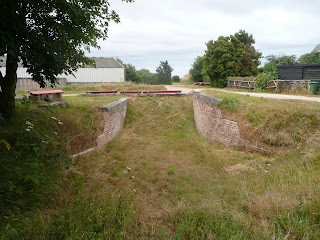
Having started on the main route it is immediately apparent how enclosed this line is now that lineside cutting no longer takes place.  As with so many disused railway lines, the path is largely insulated from the surrounding countryside, although I did get a glimpse out through the trees to the number of pillboxes that were provided here.  The jumble of lines around Groombridge would have undoubtedly given a useful corridor for German troops to march along had the invasion ever happened and the pillboxes were a necessary addition to protect this strategic route.  It’s hard now to imagine how strategic these rail lines would once have been, given that the still extant Wealden Line has been unnecessarily truncated at Uckfield and the others have all been closed.
Through the Woods
Unlike many of the lines I have recently explored the trackbed for this one is almost complete although there are a few places where the infrastructure has been completely removed.  The first example is at the B2110, where I parked.  Originally the train would have rumbled across the road by way of a bridge, but this is long gone forcing the cyclist to cross the road at level.  Fortunately on this Sunday morning there wasn’t much traffic about and this was nice and straightforward.  Shortly after regaining the trackbed I came across the first overbridge.  This line, along with many others was built to accommodate double track although in reality only a single track was ever provided for trains, with passing loops at some of the stations.  Above the cutting was yet another pillbox, sited rather awkwardly overlooking the railway.
Withyam Station
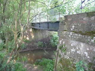
Having passed under the bridge the track resumed a straight course after a sweeping curve and I could see the track stretching out along the Medway Valley before me.  This is a section that is almost flat, in contrast to many of the other lines I have cycled on, where there is definitely a gradient (perhaps explaining why the railway didn’t make it, as trains would have been very slow along these sections).  There were no more overbridges between here and the first station at Withyam, only a succession of underbridges crossing streams that would eventually flow into the River Medway and ultimately into the Thames Estuary, some 30 or so miles away.  All along the trackside birds were warming up their voices for the day and squirrels were busying themselves with gathering food.  Although it would undoubtedly be a pleasure to ride a train along the route, these are pleasures that would be missed.  Since this is a line that is never likely to be needed again, it is perhaps the next best thing to enjoy using the transport corridor for cycling instead.
Medway Bridge
I realised that I was approaching the first station on the line some time before I reached it, as the trackbed widened out, presumably due to the sidings which would once housed waiting freight trucks.  Evidence of the former use was immediately apparent when I passed by a platelayers hut, a rare sighting on redundant lines now as many have been pulled down for health and safety reasons as they were easily vandalised.  An overgrown platform soon came into view and I could see that the station buildings were all still present, although hiding behind a large hedge.  Owners of former station buildings do not enjoy being gawped at by industrial archaeologists and trainspotters and who can blame them?  It was heartening to see the old place still being enjoyed and put to good use as a dwelling.
Hartfield Station
I crossed the road and continued on my way through a very thickly wooded section of line.  As time passed there were more track users about and the line appears to be particularly popular with dog walkers.  When I am walking dogs do not unduly bother me, but when I am on a bike I find that a lot of dog walkers seem oblivious to the cyclists needs and allow their dogs to get in the way and generally be a nuisance.  Dogs and cyclists don’t mix!  Given that the Forest Way is primarily aimed as a cycle route, I wish that promotional signage and leaflets would address this issue (rant over!).
Looking Down Over Hartfield Station
It wasn’t long before I reached Hartfield Station, another that is still complete and used these days as a pre-school nursery.  The owners have doe a wonderful job of preserving the buildings, especially for the road frontage which could still pass for an operational station.  They have also managed to retain enough of a view that railway buffs can enjoy, yet maintaining their privacy.  Out of pure nosiness I took a look at the station from the B2028 overbridge just to the west of the station.  If necessary it could be returned to use, although the chances of that happening are extremely remote. 
Three Arch Bridge
The track from Hartfield to the outskirts of Forest Row is almost completely straight, providing a seemingly never ending vanishing point to the path through the trees.  This was the quietest section of track, crossing the remotest part of the Weald on the whole route.  Every now and again I got glimpses of farms and large country houses but it was otherwise a pleasant and smooth ride, giving me time to daydream and wonder how the villages might have looked if this railway had been allowed to continue for another forty or so years.  I suspected that they would have become very desirable villages for London commuters, being only about an hour from the heart of the capital.  As it was they had not grown significantly in that time, allowing perhaps some semblance of the continuation of community life without being ruined by hoards of incomers.
Forest Row Station
I soon reached Forest Row and at this point I started to feel the trackbed starting to climb as I headed out of the Medway Valley to the summit station of East Grinstead, some three miles or so distant.  Forest Row is a village that has been allowed to grow, although growth has been modest compared to villages such as Crowborough and Billingshurst, where train stations still exist.  The volume of dog walkers increased dramatically too, and progress was somewhat slower as a result.  More noticeable earthworks began too. With the line actually entering the first cutting I had seen since way back at Ham Bridge, just outside Groombridge.
Crossing the A22
Surprisingly for a village/ small town the built up area seemed to continue for quite a long way before I finally reached the site of the old station.  Sadly this has not been as lucky as the previous two stations as the site has been built over.  Surprisingly though the two platform ramps are still in existence and the middle part where the tracks were has been filled in by a building that resembles a scout hut.  Reinstating the station would not be insurmountable if the wherewithal was there. From here though I had to take a slight detour along a parallel road as the trackbed is either further built over (a vet surgery occupies the far end of the station site) or derelict (the earth embankment leading to the A22).
Level Crossing Cottage
When I reached the A22 I was relieved to find that a proper traffic light controlled crossing allowed me to get across this very busy road safely.  The bridge that once carried the railway has long since gone, but I was relieved to find that the climb back onto the embankment on the other side had recently been surfaced with tarmac, perhaps to reduce the skidding that cyclists had to do when meeting dog walkers?  (sorry – I’ll shut up about that now!).  The remaining part of the journey up to East Grinstead is surprisingly steep for a railway and speeds achieved by small steam engines must have been very modest on this section of the line.  I took it steadily as by now it was getting quite hot and I was pretty thirsty.  I was a little envious of cyclists bombing down the hill in the opposite direction towards me, but smiled inwardly as I had chosen this direction on purpose so that I wouldn’t be faced with this climb at the end of the ride!  This was actually a section of line that I had explored previously on the High Weald Landscape Trail a couple of years ago (see http://worthingwanderer.blogspot.com/2009/02/it-felt-very-strange-starting-another.html) , but I have to admit that cycling was much more enjoyable than walking along here.
Heading Into East Grinstead

Eventually I reached East Grinstead where the trackbed abruptly ends at the A22.  The way forward to the former high level station that once served this line has now been taken over by Beechings Way (yes, groan).  Someone at West Sussex County Council must have been a great fan of the axeman’s work for this isn’t the first time I have seen a street named after the infamous Dr Beeching.  What was particularly galling for East Grinstead, which went from being a country junction of four separate rural lines, was that Dr Beeching was actually a resident of the town at the time of the cuts!  Not surprisingly he spared the one line (to London) that he regularly used as a first class season ticket holder.  Beechings Way now acts as the urban relief road for East Grinstead, taking the A22 traffic around the town centre in a kind of by-pass sort of way, before dumping drivers back onto an urban road just north of the town centre and saving them about five minutes journey time.  For that luxury, any hope of the re-opening of this line surely went by the board.
East Grinstead Outskirts
For me this wasn’t really the end of the ride, but the halfway point.  I gleefully turned around and cycled at high speed back down to Forest Row, which was a pleasure indeed!  The Forest Way is another enjoyable off-road cycle route that has given an old rail route a new lease of life and is enjoyed by a great many people if the Sunday morning cycling traffic I encountered is anything to go by.  As with the Worth Way, it is probably better to finish at East Grinstead so as to complete the uphill section during the middle of the ride rather than at the end.  Of course if you are feeling really ambitious you could do both together and make a day of it (getting from one end to the other via public transport is not that easy unless continuing on to Ashurst or Tunbridge Wells at the Groombridge end, in which case a rail transfer is possible either via East Croydon or Redhill respectively to connect back to Three Bridges).  For me though this trip completed the full set of official railway trails in Sussex.  Further trips will have to be outside the county or along unofficial trails on disused railways.  The latter possibility intrigues me – there are still several to choose from!