Wednesday, 5 September 2012

Velorail La Ferté-Gaucher

Lescherolles Station
As has now become customary for our holidays we found ourselves a velorail expedition to do on the day after we had completed a visit to Disneyland Paris.  The velorail at La Ferté-Gaucher is the nearest to the resort, but could be a million miles away given how rural the surrounding area is.  


Getting Ready for the New Travellers
This velorail is one of two established on the old line from Paris to Sézanne (the other is at Esternay some 30km or so further east).  The original line was built in 1853 and ran until 1972 but has been truncated in stages until La Ferté-Gaucher, which had been a terminus station, lost its trains in 2002 and the station is now served by bus from Coulommiers.  The station in La Ferté-Gaucher is still in pretty good looking condition should the line reopen, but the track heading westwards towards Paris is pretty overgrown in places and would need a complete replacement.  The line east from La Ferté-Gaucher has been removed through the town and now acts as a greenway for horse riders, cyclists and walkers.

Ready to Go!

We had initially assumed that the velorail operation would start at the station but we were obviously mistaken as the relative positions of the track either side of the station told us.  Despite the fact that the velorail had been signposted for some distance from the town the signs dried up as soon as we reached town and it took us some time to realise that the place where we were supposed to report to was actually the Tourist Office in the centre of town.  The reason that this was the case soon became obvious when we had to board a land train to take us out to Lescherolles station, about four miles away.


Must Get Off!
Lescherolles served what could be said to be a scattered community and it is hard to imagine that it ever warranted enough business for a station of the size provided.  In velorail terms it would seem to be big enough to cope with visitor numbers but I am guessing that parking would be a major problem and arriving by land train is probably the most efficient way of bringing in visitors.  The land train takes the route that would formerly have been taken by service trains before their cessation in 1972.  The old line is now a linear nature reserve, home to many wildflowers, butterflies, insects and other fauna.  The guide on the train waxed lyrical about these facts, but I think we only got a very edited version in English.


Through the Woods
At Lescherolles we transferred to the velorail, opting for a cycle towards the back of the queue.  As with all the other operations that we have visited since Pont Erambourg we set off at appointed times heading out as a continuous group.  We were given a new instruction on this route.  If we were faster than the cycle in front we could ask them to swap bikes so that we could then pedal at the optimum speed.  


More Obstacles
Our route would largely follow the Grand Morin River and the line adopted a fairly windy course along the valley for six kilometres until we reached the next station at Meilleray.  It was an extremely hot day and so the initial section through a heavily wooded section of the valley was quite welcome.  We had managed to develop a bit of a gap both in front and behind us, which meant that we could go at a pretty steady pace.


La Chapelle Moutils

All along the way the woods were full of butterflies, all similar species to those we would find in the UK and especially Red Admirals, which seemed to enjoy these surroundings.  Our brochure showed some points of interest to stop at along the way, but we had been discouraged from doing this on the way out so we passed by the intriguingly named Peter of the Fairies (maybe something to do with the butterflies?), the fauna and the Grand Morin River signboards.  Some of the rail features we were expecting fell a little short of expectation (such as the river viaduct, which was rather shorter and closed in by trees than we imagined), but overall it was a pleasant ride.

Crossing Keeper's Cottage
Along the way we came upon a couple of level crossings.  These were clearly busy enough to impede our progress as they were protected by bungee cords that prevented us from proceeding unless we got off the rail cycle (as required).  Looking at how busy these roads probably were it did seem unlikely that we would be involved in any kind of incident, but I guess the authorities were playing it safe.

Grain Silo
Eventually, just as we were both tiring of the trees and the long slow climb that we had done so far, the line levelled out and we lost the trees entirely.  What followed was a very pleasant trip through ripening wheat fields, already golden and presumably not long before harvesting.  Up on the hill above us was the small village of La Chapelle Moutils, with a very striking looking church that dominated the landscape that it overlooked.

Speeding Onwards
We rattled along at quite a pace along this section of track, the clunks of the rail joins making the distinctive clickety-clack sound that is sadly missing from so many railway journeys in the modern world.  The track was in pretty good order too, a far cry from the poor quality ride that we experienced in Perigord last year.  After ambling through the Morin Valley fo another couple of kilometres and negotiating a couple more level crossings we arrived at the final destination of Meilleray, signified by an old mill building that no longer fulfilled that purpose but served instead as rather a plush looking house.  A large white grain silo dominated the scene although this is clearly now served by road (if at all).

Meilleray Station
The road by the mill was an unprotected crossing but staff from the velorail operation were on hand to direct any traffic that might materialise using good old fashioned flags!  Just beyond the crossing and we entered the station at Meilleray, which presumably served an equally scattered community.  How it remained operational until as late as 1972 was a mystery – clearly the authorities were rather more generous than our politicians had been in the 1960s.  The old station building was almost buried under ivy and this will surely be the first maintenance task that any prospective buyer would have to face.  The old place was up for sale – a tempting prospect, but try as I might I haven’t been able to find any further details out about it.

Heading Back
The velorail stopped here – I imagine partly because we had actually crossed into a new Departement rather than any physical issue with continuing.  According to the map the available track did extend a bit further, but since the operation seems to be run by the Tourist Office rather than a private concern presumably the money wasn’t available for continuing ‘out of area’.  There does seem to be a long term ambition to extend the route according to the blurb on the brochures – maybe a collaboration might one day be possible?

Directing Traffic
At Meilleray we all had to turn around although this was done by the staff rather than us riders.  The turn around was much more sophisticated than other operations we had been to, with proper little turntables being employed.  We had enough time for a breather and a drink before climbing aboard for the return journey.  We aimed for the cycle we had arrived on principally because it was already adjusted to our respective heights.

Running to Open 'The Gates'
However, it soon became clear that the happy position we had found ourselves on the way out could not immediately be rectified on the way back.  Our nice lonely position was created by the person behind us being a lot slower while the person in front was faster.  The opposite was true on our return and the lady in front seemed to be oblivious as to how slow she was travelling while behind us we could sense mounting annoyance by the lack of pace.

Rushing Downhill
Luckily at the first available opportunity when we reached a level crossing we were able to swap bikes and were pleased to speed away from the traffic jam!  Being mostly downhill on our return we picked up quite a bit of speed and soon had our nice isolated feeling on the track once more.  This enabled us to see bigger creatures than just insects, most notably a deer that ran away very quickly as we approached.

Next Group Awaits
Of course when we got back to Lescherolles we still had to wait for everyone as we couldn’t make the onward journey back to La Ferté-Gaucher as we were all due on the land train.  However, it did give us plenty of time to look at the photo exhibition in the old station and grab some refreshments, which were very welcome after such a hot ride.  By now the next group of cyclists were waiting to commence their trip and were huddled together for their induction before setting off.  A degree of chaos ensued while arriving cyclists mingled with departing ones until eventually everything was sorted out and we made our way back.

Land Train
The returning land train commentary told us more about the cultural aspects of local life, including a focus on the food and drink of the area.  The main local products were apple cider and Brie cheese – a combination that is reminiscent of so many northern French regions.  We eventually got back around 5pm, making the whole trip almost 3 hours in total.  On our return we took a quick look at the erstwhile La Ferté-Gaucher station, which looked in good enough condition to still be in use if it weren’t for the dereliction at each end of the station platforms.  Maybe one day it will see trains again?

View From the Land Train
As far as the velorail is concerned we enjoyed it immensely – it was certainly one of the best operations we have been on and the scenery was very pleasant.  Hopefully an extension will be on the cards though as we did feel as if we wanted a little more!

La Ferté-Gaucher station

Monday, 27 August 2012

West Eifel Railway


Neuerberg Tunnel Northern Portal
 This year for the first time with our children we headed to the Eifel Region of Germany, a small rural corner of the country that borders Luxembourgand has a continuation of the Ardennes hills that characterise this part of Europe.  The Ardennes had a very important role in World War II, for it was here that the German Army launched a counter-offensive in the last winter of the war, with disastrous consequences as far as casualties were concerned.  It is difficult to believe now, for this area is very peaceful and full of picturesque villages among the rolling wooded hills and fast flowing streams.  It is also a good area for the railway walker to explore, for many of the old lines that once served many of these towns are long since defunct, but thanks to German efficiency have been turned into wonderful cycle tracks.

Inside Neuerberg Tunnel

In order to get a taste for what was on offer we walked a very short stretch of the former Neuerberg branch line, which once ran to this small village where we were staying from Prüm.  Prüm seems to have been something of a railway hub in days gone by, but virtually all the lines that radiated from here are now closed, although there is a preserved railway that still serves the town where the trains run to Gerolstein nearby.

Neuerberg Level Crossing
Our walk though began at the other end of the line in Neuerberg (translated as Newcastle).  The line finally succumbed to closure in 1969 to passengers and 1989 to goods traffic.  Sadly there is no trace of the former station as the flat piece of land on which it was located was just too valuable to leave derelict in this narrow valley.  The station area is now occupied by an Aldi store, but the area must have been quite large when it was an operational railway for there is plenty of room for the store and associated car park.  Pictures of what it once looked like can be found at http://www.drehscheibe-foren.de/foren/read.php?17,5406223.

Nicely surfaced

The trail itself starts immediately north of the store and the reason we even discovered it was because of the rather obvious and decorative tunnel mouth!  We thought it would be rather fun for the children to walk through the tunnel, which was on a slight curve therefore not allowing sight of one end from the other.  Although they were initially a bit apprehensive when they got inside they soon realised that it was alright as it was lit throughout.  Of course echoing shouts also helped with the entertainment value!

Picnic Areas

On the other side of the tunnel we initially walked through a heavily wooded section of track, shielded from view of the village.  The track was asphalt – no mucking about with crushed stone or any other kind of rough surface that seems to be the norm for such paths in Britain.  In fact this railway path seemed to have had a significant amount of money lavished on it.  As a result it was undeniably popular on this hot July day, with plenty of families passing us en route.
Enz Valley
We crossed the main road by level crossing protected by gates.  This must have held up the traffic when the cleared line was operational but now it would be us waiting our turn to cross.  On the other side the line took a route high above the River Enz and we were pleased to see that the trees on the river side had been allowing views of the sweep of the valley.  There was an obvious incline as the line headed northwards, which must have been a struggle for steam engines when the line first opened in 1909.

Meadowsweet
 All along the track were wild flowers and we enjoyed looking at the different shapes and colours.  Some of the flowers we recognised as they were the same as British ones, while others were new to us.  The air was full of the sound of buzzing bees and hoverflies, all servicing the myriad of flowers. 

Typical Eifel Scenery
At various intervals picnic areas had been created, making this truly a tourist attraction in itself.  We were mightily impressed – I think our next visit to this part of Germany might have to include bicycles in our luggage so that we can make this for a more comprehensive trip than the little taster we had.  We walked only about four kilometres along the track, turning back principally because we were very hot and bothered but also to ensure that the little legs of the children still had enough stamina for the return journey!  We needn’t have worried – they were too busy telling us stories to notice the distance!

End of the Line For Us


Thursday, 19 July 2012

The Serpent Trail Section 1 Haslemere - Liphook


Haslemere Town Hall


With all the rain we have had this spring and summer I am starting to get demotivated for walking even when the weather is decent as I know that underfoot will be so muddy.  Finding places to go walking is becoming almost as much of a challenge as the walks themselves!  A project that I have had tucked up my sleeve for some time is the Serpent Trail, a shortish walk (5 or six days) that weaves its way, snake like (hence the name) joining up the heathland areas of the Greensand in northern Sussex and Hampshire.  Given the sandy soils I thought it would be a good bet for a dry walk J.

Haslemere High Street
I parked at Liphook Station (free on a Sunday) and caught the five minute train journey to Haslemere.  I was immediately struck by how similar the stations were – almost like they were plucked off the supply shelf for that year.  As I wandered into Haslemere I had to dodge some fairly horrendous looking roadworks, it looked as if half the town was being dug up by the gas board.  Fortunately the star building – the fine looking Town Hall, was unaffected and the main street looked very pleasant decked out in its Jubilee/ Olympic Decorations.  Sadly Haslemere is not on the Olympic Torch Route so will not get the experience of seeing the flame pass by.
Swan Barn Walk Flowers

My route started just along the road from the Town Hall, almost opposite the point where I started the Greensand Way so years ago.  It was a rather different day today, with heavy clouds overhead threatening rain at any moment although the forecast suggested I would see some sunshine eventually.  Almost immediately I left the High Street and my battle with the mud commenced.  It was fairly unpleasant going as far as Almshouse Common but I slithered along as best as I could, passing the Belted Galloway herd of cows that I had seen on the nearby Sussex Border Path section last autumn.

A River Runs Through It
In fact at Almshouse Common, I virtually reprised my route to Black Down in the opposite direction from my Sussex Border Path excursion last autumn.  Today’s walk wasn’t nearly so pleasant, with no sunshine, mud underfoot and no autumn colours L.  There was nothing for it but to put my head down and get some miles under my feet hoping that things would come good when I got up to Black Down, a viewpoint that I know well and deserves some time and a clear view.

Black Down View
I actually made good time and got up to the top of Black Down fairly quickly.  Although I had met few people on the lower slopes when I got to the top things were rather different.  A friendly family of cyclists passed me, dropping the little lad’s helmet as they tended to his needs just past me.  They looked very grateful when I went over to pick it up for surely it would have been quite a struggle to do that themselves!  Next I passed by a woman with very different needs – in fact I was surprised she was up here at all, so old, crooked and wizened was she.  She flashed me a nice smile though – perhaps these outings keep her going?

Spotlight Sun
From the car park it was a straightforward walk to the viewpoint at the wonderfully named ‘Temple of the Winds’.  Right on cue almost the sun came peeping out from the clouds and shone shafts of light over the countryside ahead of me.  The view was superb – a result of all the rain we have had washing any vestige of mist away.  Black Down must surely be one of the best viewpoints in Sussexyet is rarely spoken about.  From here I could see the sea at Littlehampton, Chanctonbury Ring and even Malling Hill in Lewes.  These are places between 25 and 35 miles away from the point at which I was standing.  Through the binoculars I could see incredible detail and there was a part of me that wished I had just come for this view alone and not worried about the rest of the walk.

Pine Silhouettes
The early evening light got much better as the clouds parted a bit and eventually I had to tear myself away from the fabulous view I had been looking at.  The skyscape then began to take on more importance as a feature in itself as the clouds jostled around leaving clear spots here and there.  I wandered down through the Scots Pines and heathland seeing only one chap who was desperately searching for the viewpoint (he sounded German).  After that – no-one for quite some time as I headed down the slope back towards the outskirts of Haslemere.  Undoubtedly the Serpent Trail could not have missed Black Down, but in terms of progress made so far I had barely made any onward distance towards Liphook.

Early Flowering Heather
As I got to the bottom of the hill I had to pick my way through some serious mud once again.  In fact I remember this section being fairly muddy when I came this way on the SBP.  I eventually came to the A286, a very busy road that took some time to cross before heading up onto the sandy heathland of Marley Common.  After all the mud of the previous twenty minutes (some places it was almost ankle deep) I was very pleased to come across some well drained paths once again and I could step up the pace.  More of the cloud had shifted by now and the evening sun was very pleasant indeed. 

Sunlight Burst
On top of Marley Common, the Serpent Trail takes a different route across the heathland towards Liphook that the SBP.  In fact I was most relieved it did, for much of the day’s walking so far had been on very familiar territory and I was eager to see something new.

Foxglove Colour
I would say that the route taken by the Serpent Trail across Marley and then Lynchmere Commonsis superior to the Border Path Route, but then it isn’t bound by the artificial line that is the county boundary.  Yet, despite the wonderful scenery I didn’t enjoy this section as much as I should have done.  I think that a lot of woodland walking, while enjoyable, gets a bit disorientating after awhile.  I found it quite difficult to match what I was seeing on the ground with how the route looked on the map and that made me feel decidedly uncomfortable. 

Marley Common
Strangely I also think that the summer is possibly the most boring time of year for heathland for foxgloves apart, the landscape was devoid of the colours that make it so special.  Every now and again I got a splash of purple from the early flowering heather but mostly the only colour in the landscape was green.

Peeping Out
Eventually on Lynchmere Common I rejoined the Sussex Border Path and started getting anxious about the remaining light for the day.  At Lower Brookham the path takes a big detour around a school set in the woods and it sounded like a very loud end of term party was going on somewhere in the depths of the woods.  It certainly wasn’t the peace and quiet I had become used to earlier on the walk!  I also found there was a dearth of signage along this section of route and wondered whether the two were related (school and lack of signage).


Buddleia
However, I eventually stumbled onto the road heading into Liphook and was pleased to have some tarmac under my feet again.  It was a short and pleasant walk back to Liphook Station from here.  Overall I found this walk slightly disappointing, but probably because I had been spoiled with much better conditions when I had mostly done this walk in the opposite direction on the Sussex Border Path route.  Having said that the view from the top of Black Down was as good as I ever remember it and the spotlight effect created by the sun through the meagre gaps in the clouds was quite special.  I might wait for autumn tints before tackling the next section of this path though.

Friday, 13 July 2012

1066 Country Walk Section 4 Winchelsea and Rye


St Leonard's Church

Last week I finally managed to find a small window of opportunity to finish off the section of the 1066 Country Walk that I had had to abandon at the beginning of June on account of the torrential rain.  Given that there was only a three mile stretch left between Winchelsea and Rye I decided that it would be a good opportunity to do a loop and incorporate a section of the Saxon Shore Way
that had equally been spoiled by weather back in 2005, although on that occasion it was heavy snow.
Winchelsea Houses

I parked close to the bus stop where I had previously abandoned the walk and was pleased to see how much sunshine was around over Winchelsea.  With a fairly stiff wind and lots of puffy white clouds around I knew that the conditions may not last long, so I took the opportunity to take a good look around the town/ village (locals argue over the status!).

Strand Gate
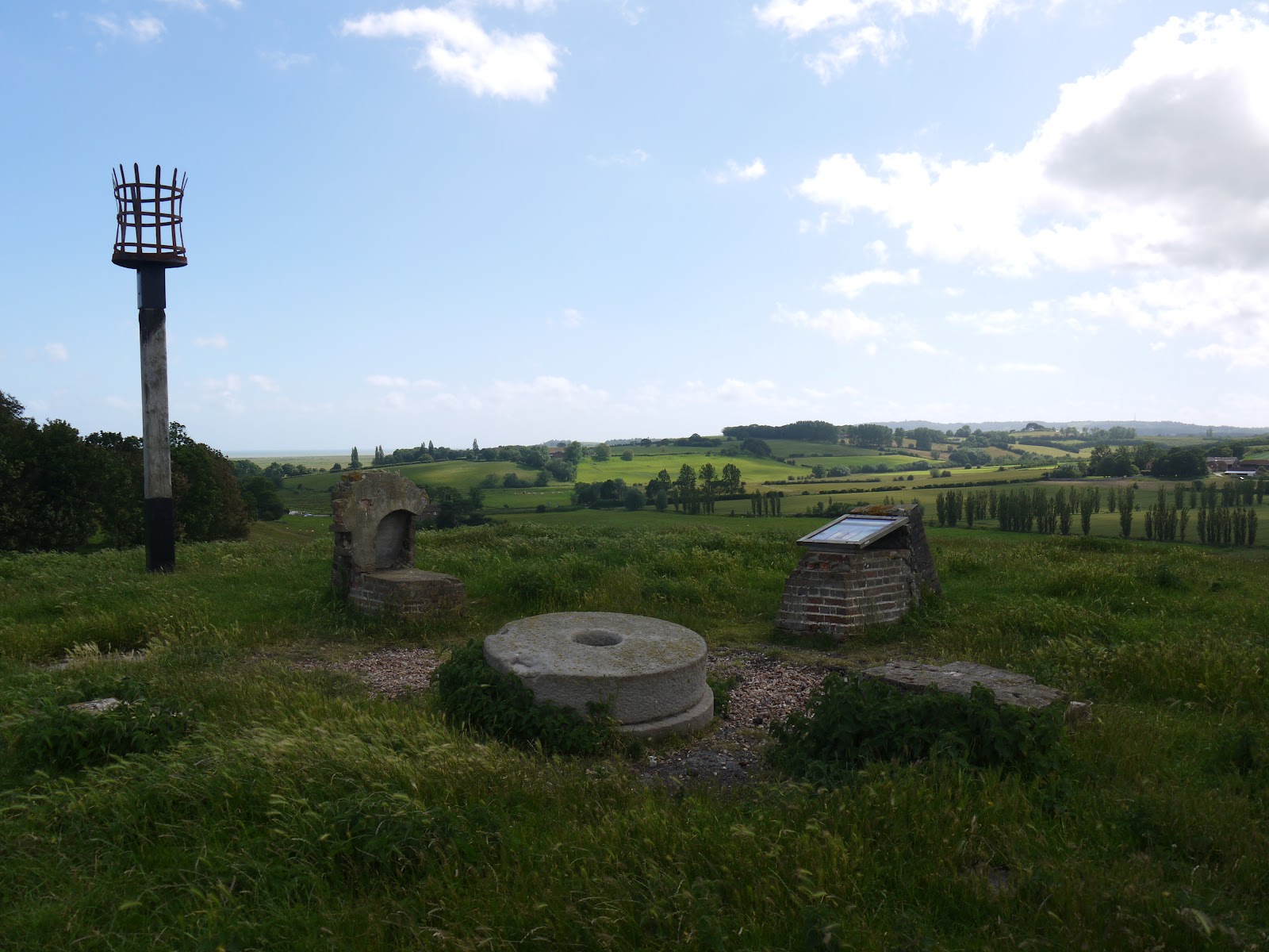
As well as the half ruined church (apparently damaged in a French Raid in the 1300s and not fully repaired) the town is very much like a quieter and smaller version of Rye, the tourist honeypot that Winchelsea faces across what would have once been the sea.  I wandered down to the Strand Gate for a look at that entrance and then a looping route to pick up the official path heading off to Mill Hill.  This was once the home of a windmill that became a victim of the 1987 Great Storm.  Only remains of the mill can still be traced after the structure was almost completely destroyed in the storm.  Just along from the remains of the mill is also an old boundary post from Hastings, a reminder of the extent of that Borough before local government reorganisation.

Site of Winchelsea Windmill

The hill itself had a prominence that far outweighed its height.  In Roman times the low lying land was full of seawater, although I suspect that it actually resembled a bit of a salt marsh and was affected greatly by the tides.  Now it is pasture and arable farmland for the most part and the former appearance can only be guessed at.  I suspect that the hill on which I was stood had a modest cliff line.  The path wound around the hill to appear back on the main road that I had crossed only a couple of hundred metres away.  In order to climb the hill, the A259 takes a tortuous route around the foot and via an enormous turn of almost 270 degrees.  I would not like to meet a double decker bus headed towards me on the bend!

Daily Commute

After my brief dalliance with the main road I headed along a country lane towards Winchelsea Station, more than a mile from the place it is meant to serve.  Probably for this reason the station has been downgraded somewhat and now only gets a service of half a dozen trains per day, with lengthy periods between them.  Not a very convenient way of getting to Winchelsea – I guess this is a ‘Parliamentary Service’ put on only to prevent the closure of the station rather than be of any real benefit to the passengers wanting to use it.  The station itself has also been rationalised, with the old station house now a private residence and that platform no longer in use.  Only a concrete open platform remains, although the railway staff have done their best to prettify it by putting some planters with flowers along its length.

Winchelsea Station

I continued along the lane until reaching a junction at the foot of what would have been the old cliff line at the far side of the valley.  The took a right at the wonderfully named Dumb Woman’s Lane – I’d love to know the provenance of that one!  I also had to take evasive action to avoid a large number of cyclists that were coming up behind me – they were also taking advantage of the small amount of good weather being enjoyed that day.

Former Cliff Line

I left the tarmac road as it headed up the hill and continued my course along the foot of the old cliff line.  This turned out to be a most agreeable section of walk – full of bird and butterfly life.  I wasn’t good enough to be able to capture any on film alas.  The constant light and shadow from the clouds scudding across the sky made for constantly different views and in this rather flat landscape the sky looked very big indeed!

Spider Meal
I had a happy moment as I approached a gate for in the opposite direction was an old gentleman, who looked to be on a similar mission to me, with his binoculars ready and camera poised.  We reached the gate simultaneously and shared a moment as we speculated on how coincidental that was when we were probably the only two walkers within a mile radius!

Rye Windmill

A little further on and in between the frustration of trying to photograph Red Admiral butterflies and rabbits running away hell for leather as I approached, I caught sight of a spider eating a hapless looking bee.  It wasn’t a spider in a web though but one cunningly camouflaged on a wild carrot flower.  An amazing sight that I had never seen before!

Swan Family
As I approached Rye I passed by a very unusual water treatment works – in fact it looked surprisingly grand for such a modest sized building.  Sadly it had been made vandal proof which had rather spoiled its good looks.  Above me was worse news though when a very large black cloud came overhead and rather spoiled my picture taking for a few minutes as it became rather dark.  Any notion of taking some pictures in Rye were rather dashed therefore and while I did linger for a short while at Rye Windmill, I decided that I would push on back towards Winchelsea rather than hang around for some more blue sky that might never come.

Looking Back to Rye


This ended my walk along the 1066 Country Walk – I have only the Bexhill and Hastings links to do now for this most agreeable little project.  It really does cover most of the main points of interest in this part of East Sussex, although if I am just a little critical of the route it would be that the Saxon Shore Way and 1066 Country Walk should swap routes between Rye and Winchelsea to make both walks a little more authentic for what they are respectively trying to achieve.

Guarding Camber Castle

Anyhow, I took the Saxon Shore Wayroute out of Ryeand headed through some very large sheep fields.  For most of the way to Camber Castlemy ears were full of the sound of bleating sheep, with the call of the lapwings that live in these parts accompanying them every so often.  It was a most peaceful evening besides that and despite the pretty good weather there were very few people about.  Before I got to Camber CastleI also had an encounter with a swan family that were getting pestered by some black headed seagulls.  I gave them a wide berth as they didn’t look too good tempered!
Royal Military Canal

By the time I reached Camber Castle, the large black cloud above me had dissipated and the castle was periodically lit up once again.  Camber Castlewas one of Henry VIII’s Device Forts, built to a similar design to others at Deal, Walmer, Southsea and Pendennis.  It was originally built to protect the Ryeanchorage, but since the retreat of the sea in these parts it now looks rather incongruous.  I was rather bemused to see that it now charges an entrance fee, which seemed a bit much considering that it is a mile from the nearest road and consists of only a ruin.  I hope English Heritage raise enough £3 entrance fees to make opening worthwhile, let alone have any money left over for renovations.  Anyhow, I wandered all round this fairly complete and lonely structure, fascinated by the enormous pits that have appeared in the stonework through 500 years worth of erosion.
Canal Crossing

By now the wind seemed to have whipped up more and the trees were blowing inside out and the clouds racing along as I re-approached Winchelsea.  I decided to walk along the Old Military Canal to the west end of Winchelsea so that I could re-enter the town through the New Gate and take another look at that in the sunlight rather than the driving rain I experienced last time.

New Gate
Walking along the canal was quite an experience.  I initially passed a young family trying their best to have a picnic hunkered down in the long grass.  Every so often a big black cloud looking like it would be full of rain would pass by and the path wasn’t the most pleasant to follow as it was quite overgrown.  I was glad to regain the road back through the New Gate and was pleasantly surprised when the sun reappeared properly for my triumphant entrance back into Winchelsea.

Wickham Manor View
On the way back into Winchelsea I saw many of the same sights that I had on the last stretch, but with the added bonus of seeing them in sunshine!  I did get a better look this time though of the house called Greyfriars, a large house built on the site of a former priory that was dissolved by Henry VIII during the Reformation.  Not much of the original priory is left for much of the stone was hauled away to build Camber Castle.  Priorities eh?  Sadly the glimpse of the house, which looks a rather grand affair, is all too fleeting and as you get closer to the house it is mostly obscured by trees.
Road into Winchelsea


I soon got back to Winchelsea to conclude my evening walk & a rather more pleasant walk it was too than trying to fight through the rain as was my prospect last time here!  The walk I followed would make for an excellent family walk, with plenty to see and learn about on the way.  I must admit to being a huge fan of this little corner of Sussex.  Sadly there is only one long distance walk I haven’t tried around here, so my excuses for coming will be soon run out…

Back to St Leonard's Church