Sunday 29 November 2015

The Vaux Stream


Druance Valley
My second walk of the afternoon was slightly longer than the first at 8km (5 miles) and as I left midway through the afternoon it was always going to be a little bit of a race against time to make sure I got back before it got dark.  However, with clearing skies and plenty of sunshine beckoning I was eager to look more at the local countryside from the gite (see last walk).
Marsangle Chapel
I retraced my steps down the sunken lane down to the right after leaving the gate and back down to the road that we had walked up from previously.  Strangely the countryside looked rather different heading down the hill versus coming up – have you ever noticed how a direction change along the same path can alter your perspective completely?
Marsangle
When I got to the bottom I turned right along the road and was almost instantly confronted with a rather stereotypical old French fellow riding a bike.  He smiled and greeted me as I passed, although he looked at me slightly suspiciously.  I had a feeling that walkers aren’t particularly common in these parts, or maybe I stood out as a foreigner?  For my part I did think that the only thing missing from him was a string of onions around his neck – everything else was there including pencil moustache, long coat, old fashioned bike and beret!
Druance Valley
Luckily this stretch of road walking wasn’t too long but the scenery was quite special.  As I headed along the small valley the countryside opened out and the autumn colours seemed heightened by the sunshine that lit up the landscape.  I turned right through the hamlet of Marsangle, passing by a small chapel and a couple of very attractive looking houses as I did so.  It wasn’t totally obvious but I think one is an old watermill converted to a house.  Unfortunately I couldn’t see for sure as it was mostly hidden by a high hedge and gate.  However, the large millstones laid against the hedge were a pretty good clue.  The chapel is also a very attractive little building, founded in 1685 by Etienne Sebire who took a vow to build a chapel here in honour of the Virgin Mary.
Marsangle Woods
It was here that I left the road and took a steepish climb up the side of a field to woodlands beyond. Behind me the view of the Druance Valley opened up and made a delightful scene of all that is good about autumn.  I was pleased that we had elected to come in October half term – I can’t help thinking that the landscape here really looks at its best at this time of year. 
Ferme de Gournay
Having admired the view for a short while it was onward and through the woodland.  It was already getting pretty dark in the trees and the path took a route through that resembled a tunnel.  Over to the left I sensed that there was a steep slope/ cliff not too far off the path but decided not to investigate too much.  I also wondered whether there might be a wild boar roaming around in the woods?  They can be quite unpredictable and didn’t fancy encountering one.  At the side of the path I saw a couple of signs that I don’t think I have ever seen in the UK telling people not to pick the fungi.  I couldn’t decide if that was because the best edible ones were becoming scarce or whether people were picking toxic ones?
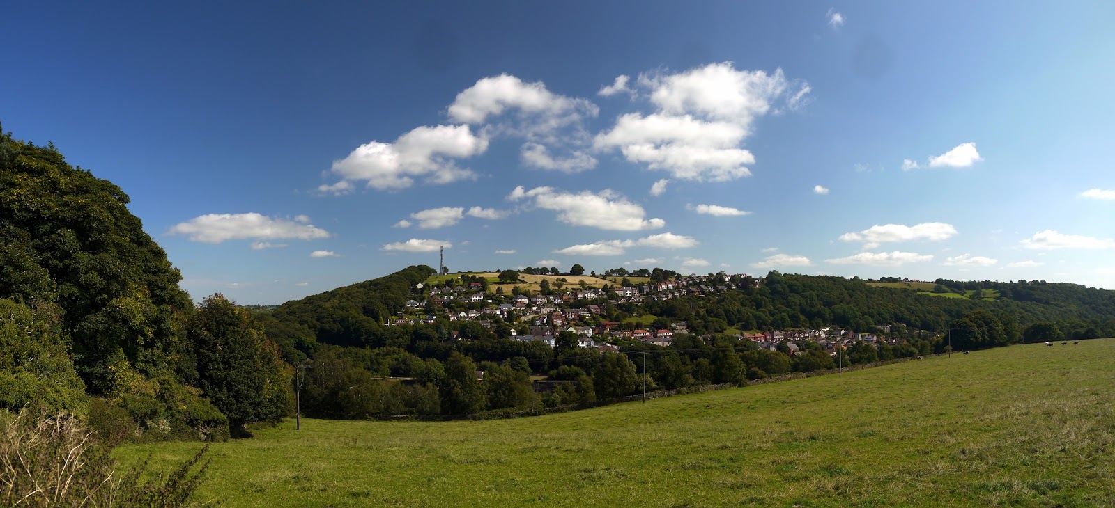
Gournay
As I emerged from the woods the clouds had almost completely disappeared and I headed up through more fields with views now opening up towards Le Plessis Grimoult and the communications mast that dominates the landscape for miles around here.  A little further on and I passed by the ruined Ferme de Gournay.  I got the impression that this might have been a victim of World War II fighting such was the overwhelming damage to the place.  Hard to believe that mere neglect could have resulted in the ruination of the building.  Whatever the cause, it seems likely that this will only be a ruin for the rest of its existence.
Autumn Colours
I took another right hand turn just past the ruined farm and headed down yet another sunken lane to the hamlet of Gournay, a settlement that amounted to no more than half a dozen houses.  As I wandered through I was greeted by another barking dog and a stern faced French woman soon emerged from the adjacent house to shoo him back in.  As I looked around at the other houses it looked like most were deserted and I wondered how many might be holiday homes.  I passed by a caravan; one of the very few I have ever seen in France.  It looked like it might be temporary accommodation for a run down looking house along the way which is surely ripe for redevelopment.

Autumn Colours
The sunken lane had also given way to a tarmac lane and this made for quite speedy walking.  When I reached the more busy road heading towards St Jean Le Blanc I had a choice.  I could continue on towards the village or I could take a longer loop that took me round another valley.  As the weather was so good I decided to take the longer route rather than more main road walking into St Jean.  I turned left at the next junction down another tarmac lane bound by trees that were the most magnificent colours.  This was surely the zenith of autumn?
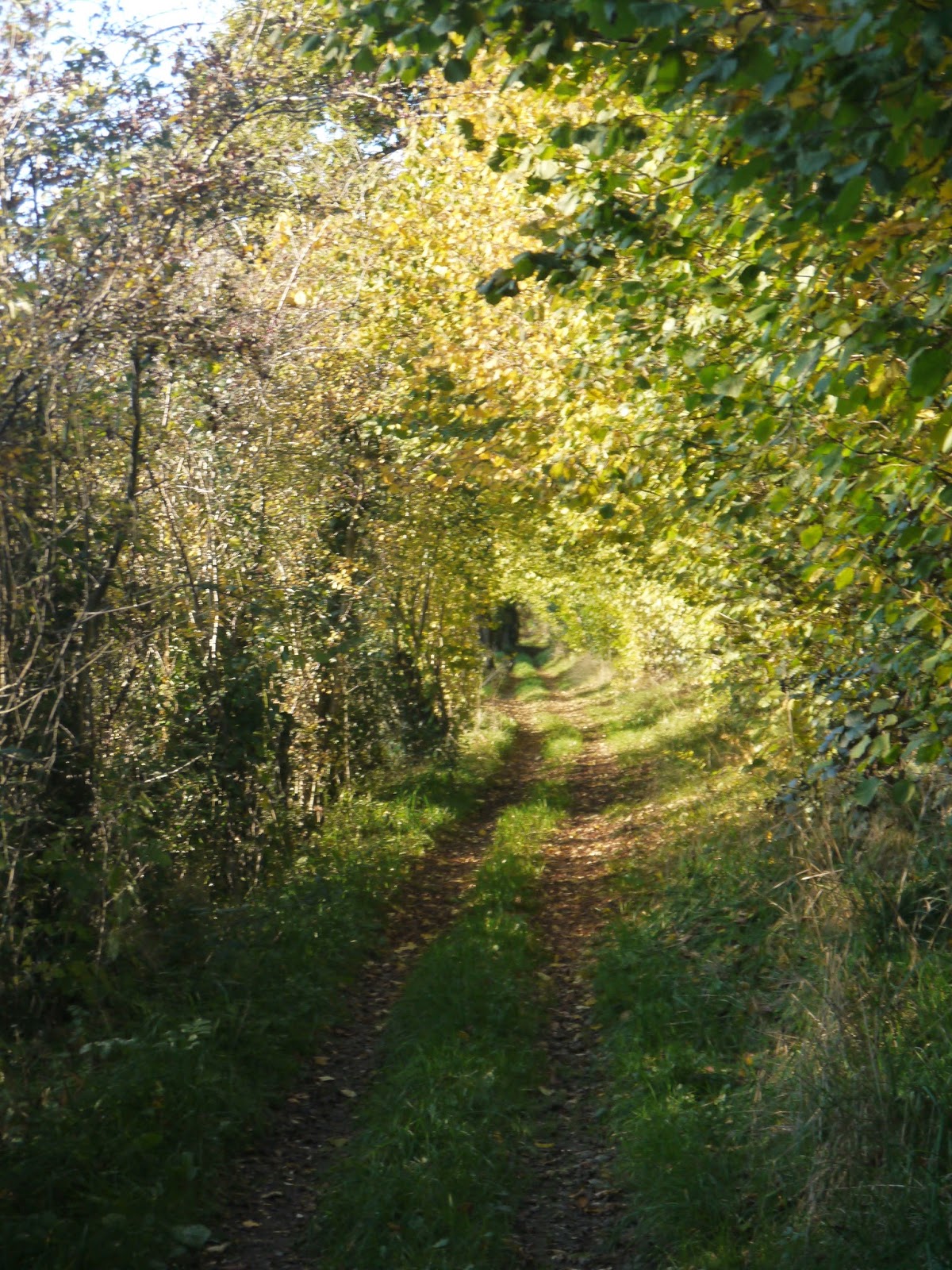
Tree Tunnel
I dog-legged around a largish property and headed along an unmade track between fields and as I did so the colours of the trees seemed to get better and better.  Most of the beech trees were a delightful golden colour and they seemed to shimmer in the low sunlight.  Eventually I came to another road and turned right then left to take a path that led along the edge of the river flood plain.  It was along this section that I had a particularly exciting encounter for as I entered the side of another woodland the silence was interrupted by a couple of buzzards who came below the tree canopy as one was chasing the other.  I'm not sure whether this was a territorial battle or courting for it was over in a flash but they were so close I could almost reach out and touch them! 

The Druance
This section of path seemed as lonely as you could think of - there were no houses and no roads.  All was silent except for the babbling stream next to me.  The dappled sunlight was quite warm by now but I could see that it wouldn't be too long before I would lose the light altogether.  I quickened my pace as a result, which was a shame for I would have liked to linger here a little longer.

Approaching St Jean-Le-Blanc
I reached another road and after crossing I almost immediately turned right and headed up a much narrower path that led slowly uphill.  Although not especially steep the length of the climb certainly got the heart pumping a bit.  I was very pleased to see the view open up behind me across the Calvados countryside, which was becoming more orange as the sun started to sink lower in the sky.  Ahead of me was the church of St Jean-Le-Blanc, lit up by the sunshine.  It was now a fairly easy walk into the village and at the junction of path with road I passed another impressive looking crucifix.  I've never quite decided whether I like them or not - some of the Jesus figures can be quite graphic.  I imagine that is probably the idea though?  This particular one was guarded by a couple of angels and is a rather grander affair than the one in Lenault.

St Jean-Le-Blanc Crucifix
St Jean-Le-Blanc is a more substantial village than Lenault and the church has a completely different style.  It looked particularly good in the late afternoon sun.  This time I didn't have to work out whether the church was open or not for a French couple tried the door as I passed by and concluded very quickly that it was locked.  They were the only people I saw in the village - it was otherwise quite deserted.  This is a phenomenon I have noticed a lot in these French villages - not sure if it is because most people are at work, or whether the shutters make it seem as if houses aren't lived in, or perhaps the houses are weekend/ holiday retreats?

St Jean-Le-Blanc Church
I passed through the village quite quickly and realised now that I would not have very much sunlight left.  I also realised that to get to Lenault there would be a steep valley to cross.  Heading down the hill was nice and easy although as soon as I dropped below the slope the woods were quite dark and I would not have wanted to be even half an hour later.  As I slogged my way up the other side the sun finally gave out just as I got to the top and the gathering gloom accompanied me all the way back to La Causserie.  Fortunately it was open road walking all the way back and so I was able to get back without the dark really affecting me.  I did have an encounter with some rather large verge cutting machines on the way down the lane.  I gave them a wide berth as they slashed the hedgerow - neither of the drivers took any notice of me.

St Jean-Le-Blanc
This was a slightly ambitious project for the amount of time I had available, taking just over two hours to complete.  Yet somehow the walk seemed much further than it actually was - not in terms of difficulty but in terms of the amount of countryside that I saw and different types of terrain I covered.  This walk could easily be combined with the other one I completed with the family earlier in the day.  The resulting loop would make for an extremely satisfying loop around the countryside surrounding Eco-Gites of Lenault.  In my opinion autumn is a particularly good time to do the walk so that you can see all the colours of the trees and absorb the atmosphere of the countryside.

Sinking Sun

Sunday 22 November 2015

Sunken Lanes of Lenault

La Causserie
This year we have had holidays that are short but more often as we found in the past that going away for extended periods of time was actually more tiring than relaxing.  We hadn't been on holiday for October half term for a few years and were keen to remedy that so we could enjoy the autumn in all its glory.  Ironically our destination was the same as the last time we went away at this time of year - to http://www.eco-gites.eu/ in Normandy, just a short distance away from the city of Caen in Calvados.  

Sunken Lane
Despite the fact that this was our third holiday to the gite the one thing we had never really done was gone for a proper walk in the local area and now the children are older we were very keen to put that right.  It was the sort of day that couldn't really make its mind up; with sunshine and cloud in equal measure, but we decided that we could still enjoy the autumn colours whether the sun was shining or not.  

Nature Taking Over
Rosie and Simon from next door kindly supplied the walk leaflet that was handily in English.  We decided upon the one from the pack that we could start from the gite so as not to have to drive.  In order to help out a bit we also took their dog with us, the first time we have ever had a canine companion on one of these blogged walks.  At the back of the grounds of La Causserie (the whole building of the gite and owner's residence next door) we turned left into one of the sunken lanes that the walk is named after.  These pathways I imagine have been here for centuries, allowing access between the small farms in this very rural part of Normandy.  This particular lane seems rather insulated from its surroundings, such was the enclosed nature of it.  There were still blackberries and rosehips fruiting in the hedgerow although the former were surely rather insipid and not worth picking.  The late ones seem to have no flavour - maybe the sun helps them develop that?

Onward
Beyond the hedge we could see some maize crops that had not yet been gathered in but otherwise the countryside was ready for the winter as far as crops were concerned.  More of the landscape was pasture and occasionally we saw a field with cows in them.  Dairy farming is more common in Normandy and much of the fresh produce goes into making delicious creamy cheeses (Camembert originates from not far from here).

Autumn Colour
Our path crossed a road and the track kept going in almost a straight line between fields.  Occasionally we got some brilliant views across the surrounding countryside and sometimes we were hemmed in by bushes and trees.  Whichever it was we felt like we had the whole countryside to ourselves as we saw barely anybody about.  Eventually we came to a road but even then our progress was unhindered and we continued onward through an ever narrower lane that became even more enclosed by hedgerows either side.  

Threatening Clouds
Eventually we came to another road and turned left to head towards the small village of Lenault.  By now the sunshine had disappeared entirely and the clouds looked rather threatening for a while.  Our walk along the road was interrupted only once by a car which was a relief.  On the way to the village we passed by a large crucifixion - these are very common in France, especially by road junctions.  This particular one looks well cared for and impressively big.  I am not sure if this is a common style but the cross seemed to be made of concrete and yet was styled to look like a tree?

Croix
A little further on and we came to the village itself.  Even by French standards Lenault is very small, with only a small collection of houses and yet it boasts a church and Mairie (what we might refer to as a village hall).  There wasn't any sign of life in the village as we passed through but the sun put in a welcome appearance just as we passed by the church.  This little 16th century church appears to have come through the World Wars unscathed - in fact I am not even sure the armies much bothered with this little corner of Calvados - there isn't really enough here to fight over.  We didn't look inside the church; partly on account of the dog with us and partly because we weren't sure whether it was the done thing to do this in France?

Lenault Church
Once through the village we headed down the most sunken lane of the whole walk - it felt like a tunnel for most of the way down to teh property of Le Hamel.  Here we were greeted by a lot of barking dogs and a fairly dirty look from the owner who clearly did not want his peace disturbed.  We didn't hang around though continuing quickly past this spot as we didn't want the dogs barking for any longer than was necessary.

St Jean-Le-Blanc Spire
As we wandered on views across the area opened up once again and over to our right we could see the distinctive spire of St Jean-Le-Blanc church across the tops of the bown and gold trees of the woods between our position and the village.  The delights of the views didn't last long though as we plunged down into a small valley with a very wet path caused by what looked like a small stream running down the middle.  As we descended down into what felt like a gully a large herd of cows came galloping across the adjacent field to check us out.  When they arrived they seemed friendly enough but I couldn't help wondering what on earth they thought they would find when they arrived?

GR221
We reached the small collection of houses called La Saulnerie and took the most delightful lane southwards.  Although bound by trees with little view out the path was particularly attractive and wide enough to suggest that it was once more of a main route than some we had used.  It now hosts the route of the GR221; a long distance path that links Coutances on the coast of the Coentin peninsula with Pont D'Ouilly in the Suisse Normande crossing some of the finest countryside Normandy has to offer.
Almost Back

Eventually we reached the road that we had crossed further north in Lenault and almost double backed on ourselves to reach a small valley.  From here it was back on to our original sunken track back up hill to La Causserie and a welcome cup of tea.  This five mile walk was enough for the girls but by the time we got back the sun was shining quite strongly and I felt like I had only just got going so after a short break I headed out to explore some more.  I think if we are to come back to this place again we may just focus on walking next time.  The countryside is delightful and we were glad that we had some walks that we could take.

Friday 20 November 2015

The Wey and Arun Canal From Billingshurst

Billingshurst Cottages

In the autumn you can never quite be sure of the weather you are going to get.  Even days when the weather forecast is set for sunny intervals this can cover quite a wide variation of sunshine and so it proved today for this walk based from Billingshurst.  We wanted a walk that encompassed a pub lunch, especially because the lunchtime period was supposed to be overcast while afterwards it would be sunny once the cloud lifted.  Sadly it didn’t really turn out that way – the weather stayed mostly stubbornly grey.  The walk in question is The Wey and Arun Canal From Billingshurst, number 14 is the Pathfinder Guide West Sussex and the South Downs.


The Limeburners
We parked in the centre of Billingshurst on a steamy kind of morning and wound our way through the streets of this small town that seems to get bigger every time I visit.  Billingshurst is a stop on the Arun Valley Line into London and for that reason it has been allowed to grow considerably to accommodate commuters heading to London, Gatwick, Crawley, Horsham and Chichester.  The growth does not seem to have adversely affected the feel of the centre of the town, but with more houses planned it makes you wonder how long this could be sustained.

Blackberries
Much of the housing we passed was fairly traditional looking and fitted in with the general character of the village so the planners had obviously been somewhat sensitive to the character of the old place.  Eventually we reached the by-pass, built alongside the housing development and diverting the north-south traffic around the town.  This also meant that the A272 east-west road had been realigned as well and so after we crossed the by-pass our onward walk away from town took us along a stub of the old road, left as an access to a couple of houses that are now largely spared the noise of passing traffic.


Boat House
We eventually caught up with the new road and the quarter of a mile or so to the pub en-route was not especially pleasant.  There did look as if there might be a short cut by the side of an adjacent field but we weren’t sure that we could access the pub from there and so walked around via the road.  The pub, called The Limeburners, is one we have passed countless times without venturing inside.  It usually looks pretty busy, which is usually a good sign.  We ordered food and beer and sat outside on a reasonably balmy day, even if the sun did refuse to shine.  It was all very pleasant and the food was certainly good enough to investigate something else on the menu another time.

Colourful Berries
Opposite the pub we took a drive that led to Guildenhurst Manor.  I imagine the manor is a very fine house judging by the beautiful tree lined drive but alas we didn’t get that far for our path took a left turn and headed across fields and through small areas of woodland past Streele Farm and down to a largish pond.  The cloud had turned almost into fog now and the air was thick with moisture.  The sun tried its best and sparkled on the water through the rather derelict looking boathouse that was our introduction to the pond.

Spider Web
Our path took us along the north shore of the pond through some pretty sticky conditions.  There was respite ahead though as we climbed up through woodland to a small ridge ahead where the ground was much drier, I suspect as a result of the underlying geology.  We also got the best view of the whole day from here although to be fair on a mostly level walk through the clay vales of this part of the Sussex Weald that wasn’t too hard.

View
We soon lost the modest amount of height gained and dropped down to Lordings Lock, a relic of the old Wey and Arun Canal and largely stranded from the rest of what is left.  The canal is billed as London’s lost route to the sea for it once joined the Rivers Wey and Arun, allowing for boat navigation from the capital city to Arundel and the English Channel beyond.  It was abandoned over 150 years ago.  The lock itself has been partially restored and could be put back to work fairly easily if the section to the south could be joined on and there was any trace of the section to the north.  Sadly the section to the north has been mostly filled in and it would take a freshly dug canal to be able to send boats in that direction.  The section to the south is in much better shape but lacks a bridge across the River Arun.

Lordings Lock
The walk from Lordings Lock back to the A272 along the course of the former canal is a familiar one to us as we often come hedgerow picking here with sloes, elderberries and blackberries all on offer along the way.  Very little of the canal is left here although there is a short stretch of dry bed in a copse of trees and it resumes after several fields near to the former lock keeper’s cottage, which is now a very desirable residence.

A272 Bridge
The A272 is an extremely busy road and crossing here is not much fun.  Luckily a gap in the traffic did present itself quite soon and over we went.  The cloud relented along this stretch of canal and we even got some sunshine which lit up the old watercourse.  This section looks like it has been restored and could take boats again without too much modification.  How long it will be before that happens is anybody’s guess for there is a significant gap to restored and operational section further north.  It really demonstrates how tough it will be to restore the entire canal.  Some of the relics are lovely though and none more so than the large lifting bridge that was put back here about 20 years ago.
Rowner Lock

We continued along the towpath until we got to Rowner Lock whereupon we took a right hand turn to leave the canal and head back towards Billingshurst.  The hint of sunshine that we got almost immediately disappeared and the walk back to Billingshurst along field edges was largely uneventful except at Rowner Farm where we passed by their magnificent display of dahlias.  What a splash of colour that was on a largely dull day!  In fact one thing that was very noticeable was that we did not meet any other walkers that day and in fact the only noise I can really remember was the beep beep noise coming from the machinery at the household waste site that we passed as we entered Billingshurst.

Rowner Dahlias
On the whole a pleasant walk in familiar territory and perhaps most memorable for the tasty pub lunch we had courtesy of the Limeburners!

Tuesday 10 November 2015

Derwent Valley Heritage Way Section 4 Cromford to Belper

Cromford Wharf
Transport between legs is getting easier courtesy of the railway that runs alongside our route now and it was only about 15 minutes on the train between these two places.  On getting out at Cromford we had to walk along the road a bit past the large pile of Willersley Castle - a manor house that was built for Richard Arkwright; the industrialist who founded Masson Mill that we had passed yesterday.  It is now a Christian Hotel - not sure I have ever heard of such a thing but in a location like this you would definitely have all the inspiration you need to find your spiritual side!  We also passed by St Mary's Church, a rather dark looking building partly hidden by trees.

High Peak Junction
It was opposite this that we picked up the path once more at Cromford Wharf, the terminus of the Cromford Canal and the transport link that made industry in this area really possible.  The link to the outside world made the transport of goods significantly quicker and more reliable in the 1780s although the pace of the canal would be pretty pedestrian by today's standards.  The visitor centre was gearing itself up for a busy sunny Sunday and the smell of bacon wafted over the canal basin from the nearby cafe.  The boat sheds of the wharf are a reminder of how the place used to operated but in truth this is a rather sanitised place, devoid of the smells and sounds that would have accompanied the industrial activity associated with the canal trade.

Leawood Pumphouse
The canal though would be our companion for the next 5 miles or so.  In truth much of it is in a fairly poor state of repair but not something that couldn't be remedied.  Considering the state of other canals that we have encountered on our routes this one is in much better condition.  Certainly for the first mile or so the canal is navigable and a boat plies between the visitor centres at the canal basin and High Peak Junction a little further on.

Grass Snake
Sunday morning activities were in full swing by now with Rugby matches going on across the valley and the canal towpath a constant stream of dog walkers, joggers and cyclists for the first mile or so of our walk.  Even the water course itself was a hive of activity with swans, ducks, coots and moorhens all grabbing their slice of the bank.  This continued for the whole distance between Cromford Canal Basin and the High Peak Junction, which came upon us rather more quickly than I expected.  I have been here before of course, most recently after completing the High Peak Trail a few years ago.  It is a curiosity of the former railway system as the railway from here was built in the canal age and predated most of the rest of the rail network.  By the time it closed in the late 1960s it was an anachronism and probably far too dangerous to be considered for preservation in an operational state.  Yet only the rails have been removed and the workshop here is a visitor centre and the canal wharf a little further on is some kind of hostel.

Waiting for a Train
High Peak Junction was the interface between the Cromford Canal and the railway line constructed across the middle of the Peak District to connect to the Peak Forest Canal in the north west of Derbyshire and from there onwards to Manchester and the industrial cotton towns of Lancashore.  The railway was built with steep inclines where the trains would be powered by stationary steam engines pulling the goods wagons up the hill.  The cables pulling the trucks occasionally snapped and runaway trucks would clatter down the hill to be caught in the catch pit below.  One is still here at High Peak Junction!

Whatstandwell Tunnel
Having satisfied our curiosity with the displays we continued on our way past the old pump house that was a little further on.  Sadly it wasn't working on the day we passed by.  Originally its purpose was to raise water from the Derwent into the canal to keep water volumes topped up.  It still looks very handsome alongside the canal.  A little further on and we crossed the Derwent by means of a large aqueduct.  On the other side of the wall we caught sight of a large snake, rather unlike any I have seen before as it was almost totally black.  However, its neck had the same ring as a grass snake and I suspect it was a variant of that species.  Whatever it was it didn't look terribly well - its milky looking eyes suggested it might be dead although another passer by looking at it thought it wasn't as he sees them regularly basking in the sun against the wall.

Choked Canal Bed
Around the corner from the aqueduct we crossed the railway that had now emerged from a tunnel and would be our constant companion all the way to Ambergate.  What was less evident though was water in the canal which was now intermittent.  I understand that the ecosystem that has been created in the canal bed along this stretch probably means that it will never operate as a canal again even though it ought to be reasonably easy to restore.

Leaving the Cromford Canal
The next 3 miles of the canal can only be described as utterly delightful.  Despite the fact that we by now quite late in the season this was a day that belonged firmly in the summer camp than the autumn one to come.  The sun was hot and the dappled shade afforded by the woodland flanking the path was very welcome.  Only a tunnel (which added a bit of spice to proceedings) and the odd cyclist changed things a bit and we all wandered along at our own pace rather staggered for extended periods of time.  Progress along this section was very quick though - we made really good time and before we knew it we were at Ambergate and very reluctantly had to leave the canal behind.  Although it looks to continue further for some distance the reality is that it doesn't go a lot further before being extinguished.
Ambergate Cricket

In Ambergate we were faced with the astonishingly busy A6 and this was rather a terrifying prospect to cross.  We did manage to find a break in the traffic though and by now we were feeling rather parched and the Hurt Arms Hotel was a very welcome watering hole.  We sat outside in the beer garden and despite having five miles of walking under their feet our children were very keen to have a bounce around on the bouncy castle that was stationed outside.  From the field next door we got the odd shout from cricketers that were playing a rather competitive sounding match.

Ambergate
Feeling refreshed we walked along the perimeter of the cricket pitch, initially along the main road and then up a side road that took us up and away from the Derwent after we had crossed it again.  We passed through a pleasant stretch of woodland before a section of road walking.  Thankfully the road wasn't very busy as walking with children on these sorts of routes is never much fun.  The views out across Ambergate and the Derwent Valley probably just about made up for the unwelcome walking conditions and by now we could also see our ultimate destination of Belper.

Derwent Valley Near Belper
We were most pleased to leave the road and the path once more returned to the valley floor.  By now the railway that we were following was not just the branch line to Matlock but the main railway between Sheffield and Derby.  The difference in traffic was very noticeable too with trains thundering by at high speed every few minutes.  We speculated on where the trains were travelling to and from for this also the main line between the south west of England (from as far away as Penzance) to Scotland (to as far away as Aberdeen).  At least one of the trains may well have been the longest direct service in Britain.  Interspersed between Inter-City trains were great lumbering freight trains, travelling a lot slower but no less impressive.
Belper Mill and Weir

Our path meandered beside fields and in between trains was most peaceful.  Autumn fruits were in full swing and many of the trees and bushes were sporting their new colours.  Yet the temperature of the day and bright full sunshine suggested that summer was still in full swing - all rather confusing really!  Eventually we entered Belper from the north west and were greeted by the most beautiful dahlia gardens I have seen for some time.
East Mill
Belper looks like an agreeable kind of place.  True there is some dereliction as some of the former mills and other industry have closed but some of the old housing built for the workers is delightful and the mill at the north end of the town flanked by a large weir in the Derwent is most impressive.  Faced with a long drive home though we didn't linger for too long; preferring to save it until our next trip.  As for this section of the walk the part alongside the Cromford Canal was possibly the most enjoyable section we have walked yet.  The section over from Ambergate was less enjoyable but that may have been because we were thinking about our trip back to Sussex by then.  The only down side of this walk is that it is quite a long way from home.