Showing posts with label Sussex Coast Walk. Show all posts

Sunday, 20 February 2011

Sussex Coast Walk Day 14 Rye - Camber

Rye
I only had time for a short outing today as the weather dictated that I would need to go on a Saturday rather than the Sunday I normally venture out.  However, I made the most of a sunny day and headed over to finally finish the last little section of the Sussex coast leftover from last month.  Having only a short time available didn’t mean that my walk was any less interesting, in fact quite the opposite as I had two walks for the price of one!  With such a short stretch of coast remaining I had decided to explore a long forgotten railway on the return leg and this will be described as a separate walk later.
Landgate

I parked up in Rye near to the windmill and availed myself of the excellent Kettle o’Fish fish and chip shop for a spot of lunch before setting out (this has long been a favourite of mine).  As soon as I had got my walking boots on and set off I heard the unmistakable sound of a steam engine whistle.  I turned to see a Black Five about to cross the railway bridge over the River Tillingham and cursed my luck as I fumbled for my camera.  I just about managed to get a picture but was far from perfect!
River Rother

Before setting off for Camber I wanted to take the opportunity for a good look around Rye, since I have failed to really do the place justice on my previous visits as it has generally been at the end of the day when all I have wanted to do is head home.  Rye on a sunny winter’s day is an enjoyable place to explore – less so in summer when it is choked with crowds.
Heading Towards the Coast

I headed up the cobbled Mermaid Street, which hosts one of Sussex’s most celebrated watering holes, The Mermaid.  This old place was once the haunt of the notorious Hawkhurst Gang of smugglers, who weren’t necessarily the romantic notion of smugglers you might expect, but a gang of thugs who weren’t shy about using violence when it suited them (see http://en.wikipedia.org/wiki/Hawkhurst_Gang for their story).  Even over 250 years later, the air of smuggling days pervades the whole town giving it quite an atmosphere that even 21st century gentrification hasn’t entirely been able to quell.
Looking Back at Rye

At the top of Mermaid Street I turned left and headed down to the main shopping street which even on a quiet Saturday seemed to have plenty of activity.  There are so many great shops in Rye, of the kind that you don’t see elsewhere very much including loose sweet shops, a vinyl record shop, proper butchers and all manner of other independently owned places that could only really be sustained in a tourist trap like this.  I wandered along the street, resisting the temptation to dive into any of the shops and headed down towards Landgate, the fortified entrance to the town centre and a relic of the time when the town was encircled by a wall.
Old Hulk

Before I continued on my way I also took the opportunity to look out from the viewpoint just above the Landgate.  The view across Romney Marsh is a very surreal landscape compared with the rest of Sussex and has now changed considerably with the fairly recent addition of the windfarm near Camber.  I could see my route almost mapped out in front of me as my eye followed the route of the River Rother below me.
Rother Reflections

I negotiated the A259 and headed across the River Rother, passing a very busy stall by the water’s edge selling Rye Bay Scallops.  These were obviously in season as the town had advertised a special week devoted to this delicacy.  The stall was doing a fairly brisk trade, although couldn’t count on me being a customer – never understood the appeal of shellfish personally. 
Harbour Mouth

On the other side of the river I took the riverbank path rather than the more direct one across the fields.  What followed was a muddy riverbank walk for a mile or so, with little immediate interest.  The view of Rye receded into the distance, replaced by rather more gritty scenes of rotting boats on the river and a waste oil refinery on the opposite shore.  To my left was a reminder of the need to protect this coast in World War II, with a very prominent pillbox keeping guard over the marshy surroundings.  Eventually after a slippery mile or so I was pleased to reach Halfway House, a large house that would once have been a landmark for visitors on the adjacent railway line that once passed by.  I turned away from the riverbank here and followed the road to the Harbour Master’s building on Rye Harbour, which strangely seems to be on the opposite side of the river to the settlement of RyeHarbour that surely would have provided better access?
Camber Sands

As I reached the road I noticed that embedded in the concrete were rails from the erstwhile tramway – more about that in the next article.  I walked along the levee above the road to avoid the cars running backwards and forwards to the launching ramp.  When I got to the launching area, I got a strong suspicion that many of the cars parked up were actually dog walker’s cars rather than boating folk, as there was very little maritime activity.  I passed by the old station and left the old railway line, preferring instead to head straight for the coast down the long straight cut that now forms the mouth of the River Rother.  My side of the river was very quiet (in fact I was the only walker), while the other side was thronged with activity probably as a result of the easier access.  It was not just people either, I could hear the thunder of some very large vehicles.  As I looked over in the distance the reason for the rumble became clear when I saw a convoy of some pretty huge looking trucks lumbering across the shingle.  I guessed that they were probably engaged in the huge task of moving the beach around to make sure that it isn’t too badly scoured by the winter storms.
Ripple Effect

A little way ahead of me the beach began and I was finally at the coast proper after walking nearly two miles from Rye.  For a change the beach wasn’t shingle, like so much of the Sussex Coast, but a huge expanse of sand, with dunes rolled up at the back of the beach.  Of all the beaches in Sussex, probably only the beach at West Wittering even comes close to this one.  The downside if you are a bather is that at low tide, it is a very long way from facilities to sea!  As the tide was out when I arrived I got to see this first hand with the sea somewhere out in the distance.  The shore end of the beach consisted of some very loose sand, so I decided to head towards the water’s edge so that I could have some more solid ground under my feet, courtesy of wet sand.
Exercise

While the beach couldn’t be said to be busy compared to a summer’s day, there was plenty of activity mostly in the shape of dog walkers, but far off in the distance I could also see a couple of horse riders taking advantage of the all weather surface for exercising their steeds.  As I reached the water’s edge, I suddenly became aware that the tide was coming in.  On such a flat beach, it was quite interesting to see how quickly the water came in and I soon got an appreciation of why people get into difficulties at other seaside locations.  Where longshore drift had created slight slopes in the beach, it was quite interesting to see how the sea created little peninsulas that then eventually got swamped.  At one point when I investigated some flotsam that was being washed in, I was soon paddling through the water as it engulfed the spit of sand I was standing on.
Closed Up Facilities

After half a mile or so of this type of walking I decided to head towards the settlement of Camber.  It’s not much of a place really, mostly given over to holiday activities and accommodation at the cheaper end of the market, such as caravan parks.  Mindful that it would be dark fairly soon, I had a quick look around at this last outpost of Sussex before the border with Kent and concluded that it was probably far more interesting to visit in the summer.  For now, the café that I went for a cup of tea at looked like it was running only a skeleton service (and didn’t look all that good either) so I opted to give it a miss.  The official end of the Sussex coast at the eastern end is by the coastguard cottages at the edge of town, beyond the holiday camps and caravan parks.  I concluded that I had seen enough at this point and decided instead to head back to Rye along the old tramway path.  This enabled me to complete a circular route, although it would also be perfectly possible to return to Rye via the 100 bus that runs frequently from Camber.
End of the Route

Although only a short trip along the coast to the end for completeness, this was nevertheless a very enjoyable walk, perhaps more so on a mild winter day when there were few people about.  The highlight of the walk is undoubtedly Rye, although Camber Sands were a superb finishing point (as long as you forget about the settlement of Camber!).  Almost two years after I started my journey along this coast, it felt good to be done!  Now for different challenges….

Sunday, 23 January 2011

Sussex Coast Walk Day 13 Hastings - Rye

Broken Remains
It’s a funny thing about walking in the winter; you can plan routes all you like but in the end it seems that it’s the weather that ultimately decides where you end up going!  So it proved today.  After a week of weather forecasts telling me that just about everywhere that was practical to go was due heavy rain, a window of opportunity opened up in Hastings when the forecast suddenly changed to ‘sunny intervals’ at the last minute.  I was very relieved as this would be my last opportunity for an outing for a month. So, a walk that I had planned last October finally came to pass three months late.
Sorry State

The official start to my walk would be Hastings station, but I felt that it would be remiss of me not to look at the fire damage sustained by Hastings pier after the arson attack last October.  I remembered how much I had hoped but worried for its future when I was last this way, and couldn’t believe that my worst fears had been realised. I hope the culprit is satisfied with his handiwork.  The destruction isn’t quite as complete as that which happened at Brighton’s West Pier and one of the buildings has remarkably remained intact.  While the general outlook for the pier appears gloomier than ever, it’s near complete destruction has galvanised the community into raising money to pay for its restoration and enough remains intact for this to be possible.  There is no doubt though that it will be a massive job, swallowing lots of cash.  I wish them well in their endeavours.  If you want to find out more visit their website at http://www.hpwrt.co.uk/ . 
Six!

I parked at Hastings station, noting that the meanies at Southern Railway now charge £1 for parking on a Sunday (it was free last time I came here) and that the car park has shrunk considerably as the whole station area is being re-developed.  There were no trains to and from Rye today either so I would be returning by bus later (slightly disappointing prospect). 
Seafront Buildings

I wandered down through the town centre passing Priory Meadows shopping centre and coming across a rather odd looking statue of a cricketer depicted hooking a shot behind.  I say odd, because it looked rather an unnatural stance for a cricketer and I suspected that it was sculpted by someone who hasn’t actually played the game.  It did remind me though that the shopping centre was once the central cricket ground, used occasionally by Sussex County Cricket Club as an out-ground.  I suppose it was too much to ask that a town centre location like this could ever stay being a cricket ground forever, but I thought it very sad that it was replaced by something as mundane as a shopping centre.  The last match was played here in 1989, against Kent rather fittingly and was attended by 1000 people apparently.
East Cliff

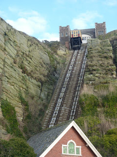
Although the cricket ground is long gone, it was heartening to see that the Odeon cinema was still functioning and opposite was a small turret boasting the best burgers in town.  I couldn’t help thinking that was quite a feat since there seemed to be standing room only inside for the server!  I headed off towards the old town, by far the most interesting part of Hastings.  The route along the seafront passed some notable buildings such as St Mary in the Castle church, the Deluxe (a former cinema now bingo hall) and of course the net drying huts for which Hastings is so famous.  I couldn’t help but notice the very well-appointed crazy golf course and then I remembered that this is probably the one that hosts the World Crazy Golf Championships!  Most of the leisure facilities along the seafront looked a bit forlorn though on this cold January day.  There was a bit more activity at the eastern end of the beach though with the shellfish shops gearing up for business and fishermen in evidence over by the beach launching area (supposedly the biggest such fleet in the country).  I wandered along Rock-a-Nore Road, realising quickly that I would have to walk to the top of East Cliff today as the funicular railway that could have provided a short cut doesn’t actually start operating until 11am and I didn’t want over an hour for opening time.  I wandered around the area have a nose at the old net shops before starting my ascent up East Cliff.
Heading Along the Coast

I was pleasantly surprised at how easy the climb was, but then I have become used to South West Coast Path type cliffs which are rather more of a test!  At the top by the upper station I lingered for a couple of minutes admiring the view back over the old town before trudging on.  The wet weather that we had had over the preceding few days was certainly noticeable, with the grassy cliff tops of Hastings Country Park very muddy and even swampy in places.  It didn’t take long for me to look rather camouflaged!
East Cliff Funicular

Having walked the next few miles in reverse when I walked the Saxon Shore Way nearly six years ago (crikey – is it really that long ago?), I was more prepared for the ups and downs of the next few miles through the Park.  First I dropped down into Ecclesbourne Glen, probably the most picturesque of the three Glens I would have to cross and yet the one I appreciated least on my last trip as it was so unexpected!  Yet despite the usual rollercoaster type terrain associated with cliff walking this wasn’t nearly as challenging as I remembered (although it helped that I was fresher in this direction!).  As I climbed up and out of the Glen the view back towards Hastings along the cliffline is impressive although I still have a hard time getting used to seeing cliffs in Sussex that are not chalk!
Hastings Old Town

After the relative excitement of Ecclesbourne Glen, the next mile or so of walking is a bit dull if I’m honest although that may have had more to do with me trying to pick my way through the endless mud than any sleight on the countryside!  I then came to Warren Glen, which wasn’t such a descent as the previous one, but was rather more wooded (which seemed to add to the mud!).  By now though the sun was well and truly out and this seemed to give me an extra amount of energy, good enough to help me up on to the next cliff.
Hastings View

There was little ridge this time and I was soon descending once again, this time down into Fairlight Glen, the last of the three.  From here I knew that the final ascent would be the last major climb of the day and although it wasn’t that hard I was nonetheless quite relieved to get all the climbing out of the way nice and quickly.  At the top of Firehills, the intriguingly named hill above Fairlight, I paused to watch the rather hypnotic spinning of the radar station, which still operates here.  I think it is a coastguard station still, although the houses next to it should confirm its original use for they are coastguard style through and through!
Hastings Country Park

As I passed by I became aware of the rather annoying cloud that had temporarily blocked the sun.  Having done so I thought briefly, the cloud then started to build and before long it looked like my beautiful sunny day would become overcast and dull L.  I headed down Firehills through gorse covered country (starting to flower – a sure sign that the end of winter is coming) and soon encountered Fairlight Cove, a rather soulless piece of suburbia that has been plonked on top of the cliffs.  My route would have to pick my way through the streets of this rather dull place until eventually I came upon countryside once again in the shape of a small area that has been acquired by the National Trust.  This would be my last piece of cliff top walking for the day, for about half a mile later I came to Cliff End, and the view onwards confirmed that I had now reached the western end of the piece of coastline dominated by shingle that would eventually become Dungeness.  I dropped down off the cliff top and headed for the sea wall, past the first of many caravan sites.  I was amused to notice that at the edge of the site was a fly-tipped chocolate brown toilet bowl.  I couldn’t help thinking that it might be part of the ‘facilities’!
Top View

What followed was almost an hour-long walk along the sea wall to Winchelsea Beach.  This was pretty dull walking if I’m honest, and was only saved by the fact that part of the way along the sun once again made an appearance and highlighted the large array of bird life that had congregated on the shoreward side of the road in the large area of wetlands left when the sea retreated from this area sometime in the early middle ages.  The Saxon Shore Way, which I had previously followed from Rye takes an inland route here, following what would have been the seashore.  Away in the distance I could also see the windmill at Icklesham, about five miles away.  I was fascinated by the light on the sails created by the low winter sun penetrating through the clouds every so often.
Fairlight

Eventually I reached Winchelsea Beach.  Sadly this is not the wonderful old town of Winchelsea, but a rather unpleasant slab of suburbia dumped by the water’s edge.  Yet, despite the rather drab surroundings there were a few things of note.  The welcome was made by a beachfront café that proudly proclaimed itself on the roof so that passing planes or helicopters wouldn’t pass by without having at least had the option of stopping!
Cliff End

The walk along the sea wall passed by yet another dreaded caravan park but largely avoided the main housing area until eventually I can to a slightly strange looking area of playing fields.  I say strange because the football pitch was in a slight hollow, like the whole thing had been engineered that way.  My suspicions proved to be correct when I noticed from a nearby signboard that this was at one point going to be a substitute location for Rye Harbour, which had silted up badly in the 1700s.  This was built as a harbour, but after completion in 1787 it had already become choked with shingle by November of that year!  It took 61 years to get this far and 7 Acts of Parliament and only kept open for three months!  The outlay for the failed project was £200,000 or over £9 million in today’s money.  A lot of investors must have lost a lot of money on this one…
Rye Marshes Coast

Just after the failed harbour I left the sea wall for good and headed across the nearest footpath to the coast at this point, across Rye Marshes, a nature reserve.  For awhile the path followed an unmade road that serviced a ribbon development of housing mostly of 1920s and 1930s vintage.  I was pleased to see that several of the houses were made up from old railway carriages and one in particular caught my eye as it was actually four railway carriages arranged in a square.  I could only assume that there was a quadrangle in the middle.
Winchelsea Beach Cafe

Eventually the housing petered out and the path continued around a number of very large gravel lakes, perhaps giving a hint as to why this area is now a nature reserve.  Gravel extraction appears to have mostly stopped although there are plenty of old machines left behind as a testament to the former industry.  Now the gravel pits are deserted, save for the odd birdwatcher (I passed a few) and the calls of the birds that frequent these watery holes in the landscape.  Across the first of the gravel lakes I caught a glimpse of Camber Castle, some distance away and passed on a very snowy Saxon Shore walk some years ago.  Today the stonework gleamed in the low winter sunshine and I couldn’t help thinking that the castle is a rather unloved treasure in the Sussex landscape.  Originally built as one of Henry VIII’s channel defensive wall, it is curious now to see how far it is away from the sea!
Railway Carriage Home

I also passed by another scene of dereliction, this time Rye Harbour Farm.  This place was bought by the Environment Agency many years ago when the sea defences were built.  The farm had helped degrade the natural environment through its intensive arable farming practices but now the Agency has given it a new lease of life by getting a new project underway to help enhance the wildlife in the area, such as it would have been when the farm started production.  Now the place looks a bit of a mess and badly in need of being tidied up.
Distant Camber

I soon reached Rye Harbour, a rather bleak little settlement that is no match for its more illustrious neaighbour that was the original port.  By now my feet were beginning to get sore after a long time walking on the concrete of the sea wall and latterly the shingle.  I didn’t hang around therefore, but headed on instead to Rye.  What followed was a rather unpleasant slog of over a mile to the main town of Rye.  This place is of course one of the jewels of the Sussex tourist scene but for me, after thirteen miles of walking I was ready to get the bus back to Hastings.  I didn’t therefore linger too long, preferring instead to wait on further exploration for the next and last very short leg to Camber and back.
Rye Harbour Farm

The walk from Rye to Hastings in either direction is a joy, with plenty of interest and fantastic scenery all the way.  For my money it is the best section of the walk anywhere in Sussex (and yes, that includes the Seven Sisters!).  Getting from end to the other is easy courtesy of the hourly rail service between the two towns (and even the rail replacement bus wasn’t too bad) and parking at each end is easy.  There are even one or two pub options for lunch, although a bit of careful planning might be required here. 
Entering Rye

I am almost done with the Sussex Coast now, just the last little section to Camber.  This is a bit of a nuisance as Camber is only a couple of miles from Rye, but I just didn’t have the time today….

Friday, 27 August 2010

Sussex Coast Walk Day 12 Eastbourne - Hastings

Bexhill Promenade
I had looked long and hard at the logistics of this section after the fantastic walk along the cliffs from Exceat and concluded that it might be best achieved on a bike.  After the lengthy section of chalk cliffs between Brighton and Eastbourne it comes as a bit of a shock to find a relatively flat coast once again.  The area of Sussex between Eastbourne and Hastings is the clay part of the Weald where it meets the sea.  Eastbourne is somewhat sheltered from the elements by the proximity of Beachy Head and the coastline is dominated by caravans and holiday homes as a result, giving a very different character to what has gone before.
Bexhill Seafront Houses

One of the reasons I chose to cycle this section of coast is that there are reputedly very good cycle lanes in Eastbourne, Bexhill and Hastings with no obvious footpath along the coast itself.  The section that looked particularly problematic was between Pevensey Bay and Cooden Beach.  Other correspondents have suggested walking along the shingle beach, but after my previous experience in Selsey I thought better of it! I had decided to park in Bexhill rather than Eastbourne or Hastings since I knew that there would be less pressure to find a space.  My original intention was to get the train to Eastbourne from Bexhill, cycle right through to Hastings and get the train back to the car.  Unfortunately it didn’t quite work out that way as due to a miscalculation on my part there wasn’t a train for another forty minutes.  I decided therefore to start my trip by cycling to Hastings and then getting the train to Eastbourne and complete the trip back from there.  It was by now mid afternoon and faced with a deadline of darkness falling by about 8pm waiting around was a luxury I didn’t have.
Grand Prix Coast

It was a sunny and breezy afternoon, perfect conditions for the ride ahead.  I had actually waited for such conditions on an available day as I felt that this stretch of coast deserved it.  The promenade in Bexhill is a short distance from the train station and the central core of the seafront has a relaxed and historic air about it.  Perhaps the fact that Bexhill has been rather overshadowed by its more illustrious neighbours (Eastbourne and Hastings) has been to its benefit.  Many of the seafront buildings have been kept in more or less original condition, rather than being redeveloped into more modern (and perhaps uglier) places to fit in with business needs.  The front is replete with traditional shelters, untouched by vandalism and painted in crimson and white livery.  There were plenty of people walking about enjoying the sea air, meaning that the ice cream kiosks were doing a brisk trade!
Galley Hill

After a short distance I came across a stone commemorating the first motor races in Britain.  Bexhill is very proud of its motoring heritage (seems rather and unlikely place now!) and hosts a gallery devoted to the old history.  Sadly there wasn’t time to visit today (make a mental note to do so soon) but I did pause for a moment to try and imagine the scene over one hundred years ago as an Edwardian Crowd would have turned out to watch the fairly rudimentary cars racing along the short course on Bexhill front.  At this point of course I wasn’t entirely sure how far they would have had to travel, but about a mile on as I climbed the slope of Galley Hill another stone marked the start line.  I couldn’t help but wonder whether the slope of the hill helped with the start – no doubt these fairly fragile cars would have benefited from a little induced momentum!
Coastway Train

Galley Hill is not much of a hill in reality, more of a sandy hillock.  But enough height is gained to make a good viewpoint above the otherwise very flat landscape.  Behind me the eastern edge of Bexhill is dominated by some rather uninspiring blocks of flats, rather disappointing compared with the magnificence of the flats on the seafront closer to the town centre.  At the top of the hill is an unusual looking coastguard station and a popular looking car park that was full of vehicles parked up to admire the view.  Ahead of me was Hastings, my next destination and a short distance away over the low sandstone cliffs that form the coastline between the two towns.  From Galley Hill the section of coast down to Glyne Gap is well-provided with a purpose built segregated cycle path, which was very welcome.  Sadly this does not extend beyond Glyne Gap but heads for the A259, a few hundred metres inland.  In my view this is a missed opportunity – the cycle lane would be so much better if it continued on the seaward side of the main railway line.
St Leonard's

I certainly wasn’t going to proceed along the road when there was a perfectly good footpath initially along the cliff top and then a stretch of shingle past Bulverhythe.  It didn’t make good cycling (and officially I wasn’t supposed to cycle) but at least there was no one around to bother or laugh at my feeble attempts to get the bike through the shingle.  On the landward side of the railway that follows this stretch of coast are the train depots at Bulverhythe, once from competing railways and facing each other.  Since the South Eastern And London Brighton and South Coast Railways fought their turf wars these sheds have been through the joint running of the Southern Railway and then British Rail to find themselves back to the original position of two operators fighting it out for customers.  The trains of Southern and South Eastern are very much kept apart in the two sheds, something I couldn’t help smiling about!
Warrior Square

Getting to the promenade at St Leonards was a relief and before finding my way on to the cycle track I crossed the small stream known as Combe Haven, once a huge inlet to what is now marshland with the former port of Bulverhythe at its entrance.  As I entered St Leonards the first impressions are not great.  The western end is still quite derelict in places and the huge site of what was once the Lido dominates the scene.  It is a sad sight now with only a few remains left of what was once quite an impressive structure (see http://www.seasidehistory.co.uk/hastings_lido.html for a good picture and history).
Marine Court

As I pushed on eastwards towards the centre of Hastings the scene soon changed and I was quite impressed at the facelift that the seafront had had in recent years.  Hastings is a town I have only visited infrequently due to its distance from Worthing (surprisingly its further away than London!).  Although I have always thought that it has a faded charm in my most recent visits it was looking pretty downtrodden in places.  Today though it looked as though many of the seafront properties had been taken on by people willing to invest more money in them.  The promenade looked as if it had also received some investment, with the gardens looking particularly resplendent with the summer bedding out in full bloom.  All the way into central Hastings the cycle lane and pedestrian facilities co-existed side by side, begging the question “why can’t we do this in Worthing?” 
Hastings Pier

As I headed into Hastings I paused to look at two remarkable buildings that have had differing fates in recent years.  First was the phenomenal Art Deco block of flats known as Marine Court.  This was the largest block of flats in Britain when it was opened in 1937 and although it can look quite ugly and slab sided at first viewing, upon closer inspection its inspiration suddenly becomes clear.  The building is said to be modelled on the Queen Mary ocean liner and the view from the eastern end makes it abundantly clear!  Since my last visit the old building has had a lick of paint and looks well cared for, after a few years when it looked decidedly sorry for itself.
Hastings Pier

Sadly the pier in Hastings hasn’t fared so well.  In recent years it has been closed for health and safety reasons as the decking is said to be unsafe.  A campaign has been started to try and save it, with the Council being lobbied to compulsorily purchase it in a bid to save its future.  I wish them well for the current state of it is rather folorn and I can’t help thinking that the problems with the West Pier in Brighton probably started out in a similar way.  At least Hastings Pier still stands; St Leonards Pier was demolished in 1951 after being damaged in a storm.  Histories of both piers can be found at http://www.simplonpc.co.uk/Sussex-Piers.html.
Carpet Gardens

I cycled through town to the station and managed to get a train within a few minutes over to Eastbourne.  I arrived at about 5.30pm and estimated that I had about 2 ½ hours to cycle back to Bexhill before darkness really fell.  I headed straight for my second pier of the day, another Eugenius Birch designed pier happily in rude health.  Personally I think that Eastbourne Pier is the finest in Sussex, although its future is also in doubt after it was put up for sale in 2009.  The seafront in Eastbourne (odd aberration like the TGWU Headquarters excluded) is also by far the best in Sussex and looked particularly good in the early evening sun.
Eastbourne Pier

I headed out of town on the excellent cycleway to Sovereign Harbour, the housing and commercial development that usurped the former gravel works that used to exist in this area of eastern Eastbourne.  As I headed eastwards the seafront and areas inland were a hive of activity with rollerbladers, other cyclists, dog walkers, a circus and people playing various ball games all in evidence.  Offshore my eyes were also drawn to the supply ship coming back from the Royal Sovereign Lighthouse, which is sited about four miles out to sea.  I wasn’t sure what the ship was doing, for the lighthouse is automated just like all the others around the coast of the UK.
The Crumbles

I soon came upon Sovereign Harbour and faced with the harbour entrance I was forced to head inland along the signposted cycle route through the development.  I was slightly annoyed by this, especially as I really wanted to take a closer look at the Martello tower almost within touching distance on the other side of the harbour.  The section through Sovereign Harbour is a bit soul destroying as it passes through a fairly sterile housing estate, with most properties adopting clichéd nautical themes for external decoration.  The marina was quite eye catching but as with so many of these types of development, the marina is almost hidden by the housing which all looks a bit samey.  Thankfully, being on a bike meant I could escape quickly.  The cycle lane continued on to Pevensey Bay and I was thankful of being segregated from the busy A259.  Across the marshes inland I could see glimpses of Stone Cross windmill and Pevensey Castle but sadly the sea was out of sight.  I caught a glimpse of another Martello tower but there was no possibility of getting any closer to that one either as it was in the middle of a caravan site.
Sovereign Harbour

At Pevensey Bay I got a rude shock when the cycle lane suddenly ran out.  I tried a few of the roads to the seafront but any possibility of heading along the coast were stopped by all manner of private signs and various fences preventing any access.  Clearly the Government are not going to find it easy to open up this stretch of coastline if they get their way to give access to all.
Pevensey Martello Tower

Stymied, I continued on my way along the road billed as a no through road to Normans Bay.  In reality there is a through route although officially the section through Normans Bay itself is private property and I wasn’t sure whether they would allow me to come this way by bike.  I needn’t have worried.  Normans Bay is a big caravan site and there were hundreds of tourists staying, making my presence almost irrelevant.  After passing through Normans Bay ‘village’ I crossed over the railway line and had a look at the rather desolate looking station.  I caught the attention of the crossing keeper, employed to keep people safe crossing this ungated level crossing.  He obviously thought I wanted to catch a train and knew I must be mad for there are no Sunday trains from here!  Actually I was just having a nose, but if he felt better watching my apparent suffering good for him – it obviously whiled away a few seconds on an otherwise boring day.
Martello Tower Coast

There was still no chance of heading along the coast so I took the road towards Cooden Beach instead.  This wasn’t an especially pleasant experience for despite its size it is actually quite a busy road and there were a few anti-social drivers around determined to ‘buzz’ me as they drove by.  It quickly made me realise why on the whole I don’t much like road cycling.
Bexhill Clock

I pedalled as quickly as I could to Cooden Beach, which marks the start of the built up area of Bexhill.  By now the sun was already starting to get quite low in the sky and I was anxious to get back to the car.  The large Cooden Beach Tavern deserved a look as I passed by and just around the corner the official cycle route along the coast started once again.  I was very disappointed by the effort though if I’m honest as it amounted to little more than a few lines painted on the road.  Inevitably it was almost completely parked up with residents cars, begging the question “what was the point?”
De La Warr Pavilion

The western end of Bexhill was very uninspiring with lots of large houses of various 20th century vintages and lived in by people who appear to value their privacy very highly, such were the high fences and hedges.  There was little in the way of sea views to be had by anyone else!  As I got closer into town I was horrified by the slab sided blocks of flats and felt thankful that this section was at the end of my trip when the light was beginning to fail.  I did end on a high note however, passing by a wonderful old clock tower and then finishing at the De La Warr Pavilion, surely the centrepiece of Bexhill (http://www.dlwp.com/).  This is surely one of the most famous Art Deco buildings of all and has gained a new audience of admirers since it was refurbished and reopened in 2005 after £8million was spent on it.  In the late evening sunlight the old place positively glowed and showed there is plenty of life in the place now it has been showed with love once again.  It was a fitting place to end my journey, albeit not where I had planned!
De La Warr Pavilion

This section of the Sussex Coast is fascinating and full of history but sadly blighted by the lack of footpath following the coast and the number of obstacles placed in the way of anyone daring to explore the coast.  My choice of bicycle to make the journey was fully vindicated though – some of the best cycle lanes in the county are through the three main towns.  Perhaps my only regret was not having a few more hours to do it complete justice.  The De La Warr Pavilion in particular demands a visit to have a look at the art – I think that may well be on the cards in the months to come.