 |
| Burgh Island |
When I planned this section it was in the knowledge that there is virtually no public transport in this area and a loop was on the cards, taking in the villages of Kingston and Ringmore. However, I didn't think for a minute that I would be completing the route in February and conditions on the ground weren't really conducive to completing a loop through muddy farmer's fields. I instead opted to complete the section as more or less an out and back from Bigbury-on-Sea. It was a little messy doing it this way but as a result I found myself going the opposite way along the coast path, something I have not yet done!
 |
| Sea Tractor |
Parking at Bigbury is quite an expensive proposition so be sure to have plenty of coinage with you when you go. I struck lucky as on my arrival a car was pulling out of one of the few free spaces at the bottom of the hill that leads into the village. I quickly clocked that the tide was out and before I started my main walk I decided to take advantage by walking across the beach to Burgh Island. This rather unusual island is linked to the mainland at low tide - when the sea is in the only way across is via a specially adapted 'sea tractor'. The island was a bolthole for the rich and famous back in the 1930s when an art deco hotel was built to cater for the demand. Even now it has an air of exclusivity about it. The island served as inspiration for two Agatha Christie stories; as Soldier Island in 'And Then There Were None' and also for the Hercule Poirot novel 'Evil Under The Sun'.
 |
| The Pilchard Inn |
I walked across the sand taking care to avoid the cars going backwards and forwards from the hotel. I imagine arriving and leaving is both more adventurous and problematic at high tide! Once on the island proper I walked up the modest slope to the former chapel at the top. After it fell into disuse as a chapel it became a huer's hut where fishermen would keep a look out for pilchards shoaling and raise the 'hue'. The view from up here was certainly magnificent and I lingered here for a while. In fact it was while up here that I hatched the plan for the day's walking, having seen the terrain and opportunities available to me. It looked like the tide was still going out, something I hadn't quite appreciated when I rushed over here.
 |
| Avon Estuary |
I walked back to Bigbury-on-Sea and availed myself of the welcome beach cafe before heading out up Folly Hill. I rather hoped I would see a folly but sadly did not. The path was a little sticky but crucially went up the side of a field alongside the road so I didn't have to worry about dodging the traffic. At the top I took one look at the farm track that I had previously thought would be my onward route and decided that I had made the best choice by taking the official path instead down to the ferry dock that would take me across the River Avon if I were here in the summer. The path passed through Mount Folly Farm, owned by the National Trust and worked on organic principles. I weathered the very barky dog and pushed on to the most magnificent viewpoint that looked down on Burgh Island, the Avon estuary and the coast eastwards towards Salcombe.
 |
| Boathouse |
The path down to the estuary was a little tricky in places and as I walked down I realised that it would not be necessary to retrace my steps back up this steep path, courtesy of the low tide. Instead when I got to the bottom I decided to head round to Bigbury-on-Sea by walking around the exposed sand alongside the river. This proved to be an enjoyable and satisfying way of closing this section of the loop. By the time I got round the the Beach Cafe again I decided that a hot drink was in order before tackling the main course of today's walk.
 |
| Challaborough |
My first task was to get around to the neighbouring settlement of Challaborough. This looks like a village on the mp but is actually a large caravan park and rather a brutal looking one not really sympathetic to its surroundings. The path around from Bigbury looks like it was once a road but one which has suffered from too much erosion to make it viable. The tarmac surface was still there even though it was a lot narrower that any road would be.
 |
| Challaborough |
I passed by the rather bleak looking caravan site and the associated service buildings, including the pub and a couple of shops. They really looked uninviting on this cold February day; I hope they are rather better when there are plenty of people about in the warmer months. This was actually the last settlement I saw on this stretch of coast. I was soon climbing to the top of the first headland and was pleased to see that the underfoot conditions weren't too bad. Any notion of a stretch of high ground to walk along before the next drop into a hidden beach were soon scotched - almost immediately from the climb I was back down almost to sea level. As I descended I could see that there were at least 3 more climbs to go. I must admit though they didn't look too bad and I found them a lot easier in the colder weather!
 |
| Ayrmer Cove |
The first cove I dropped into was Ayrmer Cove and this probably had the best beach of all of them. Not many people enjoying it today though - just a couple of people with their dog. It was straight up the other side via a short but stiff climb and then almost straight down again. The climbs were perhaps a little more modest than other stretches I have done but there was almost no time to settle before the next ascent or descent. The next beach was Westcombe Beach and by now I had left other walkers behind me now that I had strayed a lot further from the nearest parking areas.
 |
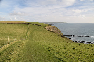
| Viewpoint |
At Westcombe Beach I saw a small and curious looking building. It looked like a cross between a public toilet and a milking parlour. I wonder what it was used for? The next climb was the stiffest of the lot and took it slowly and methodically before finding a very welcome bench at the top of the slope. This was clearly someone's favourite spot for the viewpoint was quite wonderful and definitely a good place to linger. This was the last major climb of this direction - I of course knew that I had it all to do again on the way back!
 |
| Heading Into The Erme Estuary |
There was one more down then up but fortunately I didn't have to head all the way down to sea level. This time it was only a bit of an undulation but quite a sticky climb as somewhere in the bottom was a stream that had fanned out to form a marshy area. As I looked back I quickly got the sense I was being followed by someone rather quicker than me. I never like that to be honest - I never know whether to wait for them to go by or try to speed up. In this case I didn't do either - he soon caught me up anyway! Actually he seemed like a nice chap and passed the time of day with me as he passed me at The Beacon.
 |
| View From The Beacon |
It was at this point that I also turned direction to head into the Erme Estuary. It was a gentle descent down to the beach and I could see how it would be possible to ford the river in order to cross it. I was glad I didn't need to do it today though as I had missed the window of opportunity; the tide was now too high. It was a pretty popular spot though with the sands surrounding the river full of dog walkers and people otherwise exploring the beach. I lingered for a while enjoying the scene before summoning up the energy to head back in the normal direction for my walk.
 |
| Erme Estuary |
It felt more customary to have the sea on my right hand side. My return walk was largely without incident and although I was retracing my steps it didn't actually feel too bad going over the same ground once again. If anything it was easier knowing how to pace myself for the climbs that I knew would surely come. This time I think it was the last one that got me the most but that was as much about the underfoot conditions as the steepness of the climb. All the way back I became fascinated by the sight of the tractor going backwards and forwards across the now underwater sandbar between Burgh Island and the mainland. I was rather amazed by the level of demand!
 |
| Heading Back |
All too soon I was back at Bigbury-on-Sea feeling satisfied in spite of the unusual way I had to tackle the section. I even managed to stay mostly mud free - a minor miracle in itself! The section is picturesque and the visit to Burgh Island fascinating. Next time I might go the whole hog and stay in the hotel over there - not sure I would want to be hiking though...
 |
| Closing Causeway |


