Wednesday 31 October 2018

South West Coast Path Section 58 Swanage to South Haven Point

Swanage Promenade
This was a day of mixed emotions for me.  On the one hand I was in celebratory mood for this marked completion day on the South West Coast Path, while on the other I was sad that not only would I be finishing with this walk but that I wouldn't actually be doing any more UK walking for quite some time as only a week from this day I would be emigrating.  Regular readers may have noticed that my only walking for the last few months has been on the SWCP and it was for the very good reason that I was anxious to finish the path before leaving the British Isles, for who knows if I might have another opportunity?  More about my destination in the next blog entry.

Lunch Stop
We had long discussed my last short stretch of the path (this section is only 7 miles) being a family affair and as agreed my wife and two daughters came to celebrate completion with me and walk the last few miles.  It promised to be quite an easy section for them to do, especially compared with the preceding few miles from Weymouth, which is up there with the most challenging sretches of coast along the whole path.  We took the Sandbanks ferry over from Poole and parked immediately the other side at South Haven Point.  As we got on the ferry my worst fears were realised when I saw not one but two of the buses heading to Swanage ahead of us.  I knew that we were most likely going to miss both of them and face a lengthy wait for the next one.  We struck lucky though when we managed to be directed off the ferry ahead of both of them, in with sufficient time available that we were able to get parked up and run for the bus.

Climbing Ballard Down
We sat on the Swanage Breezer with the wind blowing through our hair when a horrible thought struck me.  Had we closed the car door in our haste?  Too late now I thought - by the time I would have got back the damage would have been done.  I decided that hopefully one of us had shut it and we continued on our way.  We got off at Swanage station to enable us to have enough time to go and get some refreshments before getting underway.  We were blessed with another glorious day and unlike the last time I was here a few weeks previously Swanage was incredibly busy.  School holidays do that to a place - suddenly the best places become overwhelmed with visitors when families start rolling in.

Ballard Cliff
We grabbed some pasties and drinks and headed off along the promenade.  The beach was rammed - Swanage is clearly even more popular than I imagined.  It isn't surprising - it is a beautiful location and provides everything a family could wish for.  For so many of the families it looked like the perfect day out and the kids were clearly loving being free from school.  My two were happy to be following their old Dad though - they weren't too bothered about the beach.  At the far end of the promenade we started to the climb to Ballard Point.  Although it looked somewhat daunting it was nothing compared with other climbs along the South Dorset coast and as I reminded my girls it was the only one of the day.  Once at the top it would be downhill until the end - a rather gratifying thought!

Walking to the Isle of Wight
After passing through 'New Swanage' we resumed course along the coast, finding ourselves a rather pleasant place to sit for our lunch.  I think I wore a perma-grin for the day.  It was perfect in every way - blue skies, warm, breezy and a pleasing amount of cloud bobbing overhead which meant for constantly changing light.  The view from our spot over Swanage was quite superb and even the walk ahead wasn't daunting.  I reflected that I had done a good thing by leaving this short stretch to the end rather than trying to tack it onto the section from Chapman's Pool.

Old Harry Rocks
We took the climb up to Ballard Point slow and steady and discovered that it actually wasn't nearly as bad as it looked from below.  As we wandered up we could hear the whistle from the steam train, which sounded as if it were heading up the line towards Corfe Castle.  The view along the Purbeck Ridge was something special too.  One day I will walk it - have been thinking about it for a very long time.  At the top of the hill the path flattened out and proceeded along a ridge above Ballard Cliff to the Point bearing the same name.  Our view right was very special indeed - this section for me was probably the best of the whole day.  

Old Harry Rocks
At Ballard Point the height was suddenly lost as the Isle of Wight came into view.  This was to be expected for Ballard Point is like a mirror image of the Needles which it faces.  Instead of the Needles this headland has Old Harry Rocks, a rather similar if less celebrated feature.  As we got down to view them closer it was clear that many people had been drawn from the car parks at Studland to come and look at them  too.  Cormorants seemed to love them too - there were plenty on evidence clinging to the sheer faces.

Studland Fort
For us that was the end of the high part of the day - the path now continued along the level path around Studland Bay.  Initially this was a very well walked path along a grassy strip between Studland Wood and the sea but we eventually hit a short stretch of road at Studland village.  The path diverted seawards away from the village and at Redend Point we passed by a large hotel that was in the throes of having a garden party - looked very pleasant.  At the seaward side of the path was a rather different kind of structure built for war rather than pleasure.  This was one of the wartime defences; still looking very robust and in good condition.  Studland Bay was considered to be quite vulnerable during the war for it was somewhere that could easily have served as a landing site.  When the imminent threat passed it then became one of many beaches that was used for D Day training exercises.  Looking at its visitors today it is hard to believe that such a short time ago it had tanks and troops using the bay.

Studland Beach
The last three miles took rather longer than expected as we traversed Studland Heath nature reserve.  Indeed we weren't even sure which path to take at times.  We started at the back of the dunes as initially the going was easier but eventually the path ran out and we had to go along the beach.  As we wandered along the back of the dunes we became aware of a naked man posing on top of the dunes and I remembered that this is a nudist beach.  A walker behind us was clearly quite embarrassed at the prospect of going along the beach and he disappeared into the heathland while we decided to front it out.  The reaction of my two children to walking along a nudist beach was quite entertaining.  One decided to walk head down and not look at anyone or anything around her until the coast was clear.  The other had a sneaky peak with much interest and trying to disguise a smirk the whole way.  We were pretty relaxed about it although I did feel a tad overdressed at times!  She got a good biology lesson I suppose...

Sandbanks Ferry
The last stretch along the beach wasn't terribly interesting although the number of people that we saw increased significantly as we got closer to the ferry.  Our pace quickened too as we started thinking about the car door.  I also wanted to see about getting a celebratory ice cream at the end.  Sadly that last part didn't happen as there wasn't anywhere to buy one.  I lingered for a photocall at the sign at the end of the walk but otherwise I thought this was a slightly anti-climactic end to what has been an astonishing walk.  So after 12 years, 3 months and 23 days I finally conquered the challenge of the path and just in time.  I was helped considerably by the beautiful summer weather that allowed me such good conditions to complete the walk.  Eight days later I left the UK and have not been back since.  That wasn't a script I expected at all!  My new whereabouts will be revealed in my next blog entry.  As for the car door?  Turned out my daughter had closed it!
Completion!


Monday 8 October 2018

South West Coast Path Section 56 Lulworth Cove to Chapman's Pool

Lulworth Cove
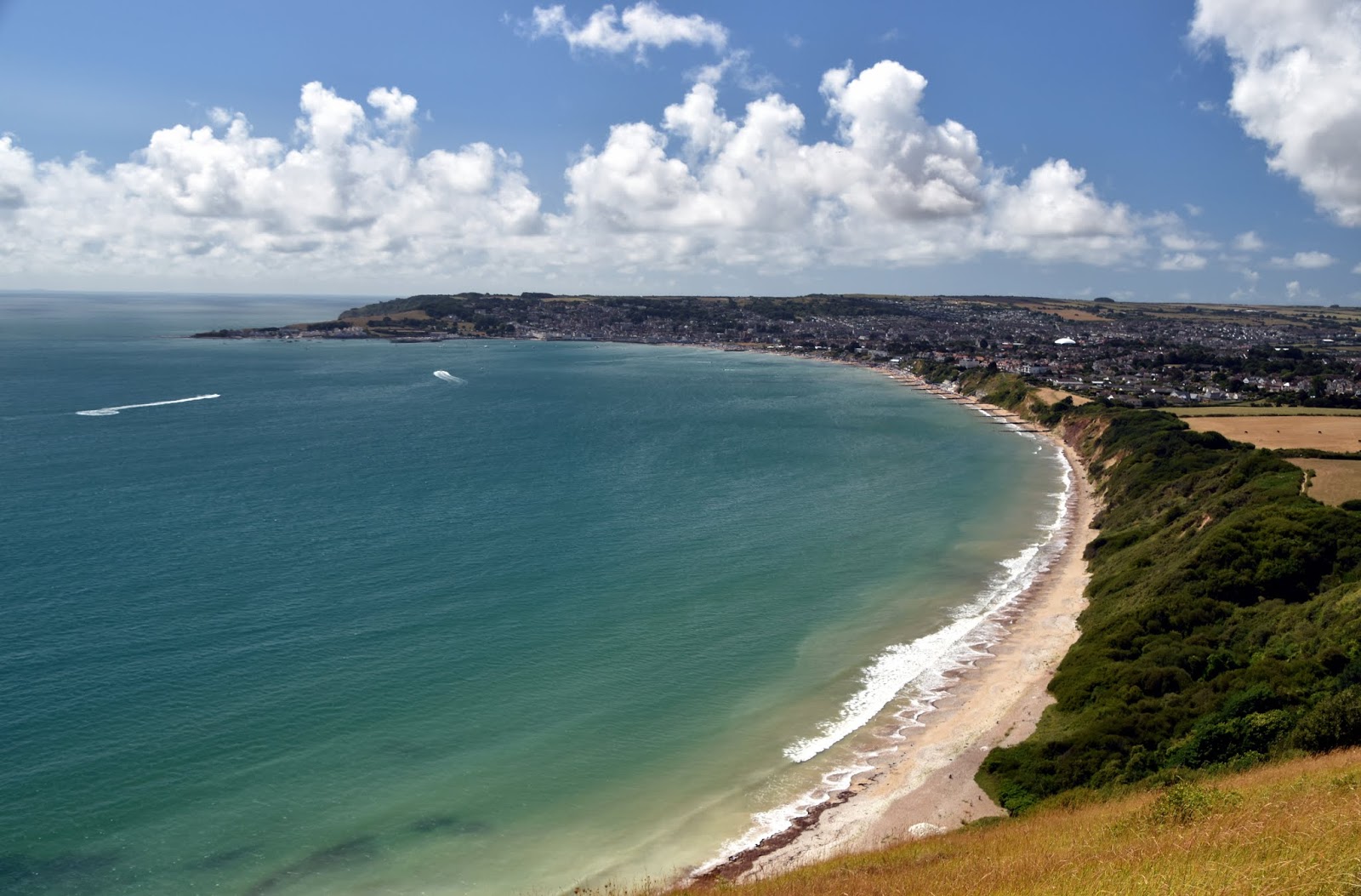
This section was a major milestone for me as it was the last section of the coast path that I would walk alone.  I had only one section remaining after this - the short and relatively easy section from Swanage to South Haven Point - and that last section would be a celebration with the rest of my family.  However, I still had this rather formidable section to complete and I had left it so late principally because of the difficulty of crossing through the Lulworth firing ranges and also the rather difficult public transport arrangements.  Both of these factors were solved by the fact that I did this walk on a Sunday when the firing range wasn't in operation and summer bus services were to help me.
Lulworth Cove Overview
I set off early from Worthing to find the parking spot that had served me well at Kingston village only a few weeks before.  From here I got the bus and was supposed to change at Wareham.  The connection didn't quite work and I faced a lengthy wait at Wareham so I was very pleased to see the Lulworth bus ahead of me at Corfe Castle and managed to switch buses in the nick of time!  That quick thinking spared me a lot of hassle later on and also meant that I was able to get going on the walk a lot earlier than I dared hope.

Fossil Forest
It was another very hot day and on a lonely stretch of coastline where I wasn't sure if I would see any refreshment opportunities I made sure to stock up before I left Lulworth.  Being a tourist place though the prices were a bit steep so I bought the minimum of stuff and hoped that I would find somewhere else on the way.  My first problem was a change of route out of Lulworth due to a cliff fall.  It was tempting to merely walk along the beach at the back of Lulworth Cove but I wanted to get a look at the view from the top and so made my way along the diversion which took me inland some distance before striking straight up the side of the hill that is due east of the village.  It was the first but no means least of the climbs that I would have to do today.
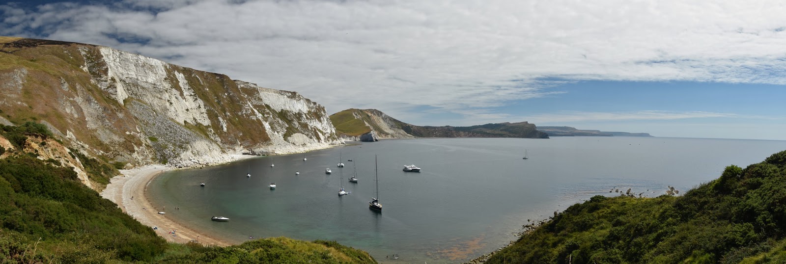
Mupe Bay
Despite the heat there was quite a nice cooling breeze on the clifftop and this would serve me well during the day.  The beachgoers were now far below me and their laughter and screams were barely audible now.  I had a fairly level path at the back of the cove and the views were quite special, both back towards Lulworth and onwards to the section of coast that I now had to tackle.  It looked a bit daunting but I thought I would take it slow and steady for I had no rush now that I had dealt with the public transport.  At the back of the cove the path descended quickly and steeply towards Little Bindon down the side of the army ranges, bound very menacingly with a long barbed wire fence.  The red flags were flying but it was supposed to be a non-operational day.  I suspect these ones high  up on the range are left in situ all the time as a reminder.

Mupe Bay
After dropping all the way down to sea level almost I then had a short climb up to Pepler's Point.  This eastern side of Lulworth Cove is named after George Pepler, who was once the tenant of Little Bindon nearby.  This house was owned by the Cistercian Abbey of Bindon some distance away at Wool and is now a listed building although given that it is within the army range I doubt that anyone resides there currently.  Pepler's view is certainly worthy of the short diversion to get there.

Bindon Hill
I crossed into the army ranges through a very secure looking gate and the next few miles would be through Ministry of Defence land.  This is often off limits and coast walkers need to plan when to come for most of the time you can only walk this stretch at the weekend.  Almost immediately I dropped down to the viewpoint for the fossil forest. The fossil forest is the remains of an ancient Jurassic forest that was submerged around the time that the limestone was formed.  The trunks of the trees are long gone but you can see holes in the rock where the trees would once have been.  There was a notice warning people not to walk around on the cliff shelf where you can see the forest but of course there were people that had ignored it and were taking selfies of their exploits.  Satisfied with a long range look I walked on along a level cliff for a while.  It felt good for now but I could see the cliff at Bindon Hill ahead and knew that a stiff climb was to come.

Ex-Tank
The view out across Mupe and Worbarrow Bays was quite something.  I lingered here for a while and was asked by a German couple suggested routes for their walk in the area.  When I pointed to where I was walking to way off in the distance they politely accepted my suggested route and walked off in a different direction.  I think they were looking for something rather easier and who could blame them?  I set  off up the hill at a slow and steady pace - I have discovered that really works for me now.  I didn't even feel the pressure of another couple coming up behind me at a faster pace - they soon underestimated the steepness of the path and ground to a halt while I plodded to the top without stopping.  I was pleased I made it before them as there was a very welcome seat which I made full use of.

Flowers Barrow View
Enjoyment of my newly found height was very short lived as I was soon to plunge all the way down to the beach head at Arish Mell.  As I descended I was fascinated by the battlefield off to my left.  The army exercises are all played out here and the landscape was littered with spent tanks.  They cut rather a forlorn figure in the heathland landscape.  Off in the far distance I could also see Lulworth Castle and it looked as if they were having some kind of special event as the grounds were full of marquees.  Once I had descended to the beach head I could see that was off limits too - the beach head no doubt serves as a crucial training ground and probably has plenty of redundant miltary stuff hanging around that wouldn't mix with members of the public.

Worbarrow Bay
I now climbed to the top of Flower's Barrow - another stiff test.  As I made my way up the hill I joined a group of scouts and soon passed them by as they were mucking about and were clearly feeling the effects of the hot day.  The fact that I was at least 30 years older than the oldest of them wasn't lost on me - it made me feel pretty good that I passed them! At the top I sat on the ramparts of the long barrow for some time drinking in the view as well as copious amount of water.  In this dry summer it was particularly noticeable how dry and parched everywhere looked.  It is an astonishingly good view though - perhaps the best in the whole of Purbeck...

Worbarrow Bay
Once I had gathered my strength once again I crossed to the other side of the barrow where I came upon a huge rambling group and thanked my lucky stars that I hadn't encountered them earlier.  Again I didn't really have time to enjoy my new found altitude - it was straight back down a steep slope to the back of Worbarrow Bay.  As I descended I saw a runner going in the opposite direction.  I was sure whether to marvel at or ridicule his efforts in the hottest of midday temperatures.  Either way he was supremely fit and appeared not too troubled by the steepness of the climb.

Tyneham Church
At Worbarrow Bay I had a quick look at the view and back at the two huge hills I had climbed with some satisfaction.  The rest of the day wouldn't be quite as tough I thought.  I took a detour at Worbarrow Bay for there was a rather special place I wanted to take a look at away from the coast path.

Ghost Village
Tyneham is a village that I visited on a cold February day many years ago.  It was deserted and a little eerie, befitting its status as one of the most famous abandoned villages in the UK.  This lonely place was requisitioned by the Ministry of Defence during World War II to enable troops to carry out training exercises ahead of the D-Day landings.  The villagers that were moved out were on a promise that they could return when the war was over.  However, in 1948 the Army completed a compulsory purchase order over the village and it was incorporated into the Lulworth Ranges and the villagers never returned.  Subsequently the village was battered by shelling and other army exercises and most of the housing is ruined.  I was keen to take another look but this time I was a bit disappointed.  Much of the village has been tidied up for visitors and somehow the atmosphere was all wrong on this hot and sunny day with dozens of people milling about.  I had hoped that the number of people here would bring some refreshment opportunities but sadly not.  I had to hope for more opportunity further on.

Tyneham Valley
After having a look around and going inside the school room & some of the houses I returned to the coast path.  This section was more level once at the top of the cliffs.  I wasn't expecting anything quite as spectacular as before but I was wrong.  The underlying geology had changed now - instead of limestone there was now shale and the nature of the cliffs was far different as a result.  As I rounded Brandy Bay and Tyneham Cap the geology became more evident as the bedding planes came into view.  Looking back along the cliff that I had walked I could also see the land slipping that was characteristic of this rock type.  In many respects it was similar to that beyond Lyme Regis although much smaller in scale.  I absolutely loved this couple of miles - in many ways it was my favourite part of the day's walk.

Tyneham Coast
At the bottom of the hill I passed through the fence that marked the other end of the military ranges.  The military controlling this area is definitely a mixed blessing for while it is awkward to walk across here due to operational timings, the fact is that the landscape is a real haven for nature as largely it has been left alone.  Once through the boundary I then passed an unusual sight in England, an operational oil well.  The pump has been here for many decades - I remember learning about it in my geography lessons at school in the 1980s.

Broad Bench
I soon came down into Kimmeridge Bay where the busy beach suggested that there might be some refreshments available.  Luckily this time I hit the jackpot in the shape of an ice cream van.  The ice creams were fairly poor quality but no matter - it was ice cold and went down a treat as I was boiling by now.  It set me up nicely for the last few miles starting with the short climb to Clavell Tower.  This folly was built in 1830 by Reverend Clavell and is now used as a holiday home.  It was moved back from the cliff edge in 2008 in an operation that cost nearly £1m.  I imagine that it is quite expensive to stay there in order to recoup that money!  There were a couple of people in residence as I wandered by - looked like a relaxing spot although residents must be constantly gawped at by sweaty hikers like me wandering by.

Clavell Tower
The next couple of miles were quite uneventful and relatively easy going apart from a couple of diversions around cliff falls.  I had been pre-warned of a large hill at the end of the day though and as I went on I saw it loom ahead of me.  In fact what I wasn't totally prepared for was that there were actually two steep hills at the end; the first one was just a taster for the bigger one at the end.  They were more than a sting in the tail.  I really had quite a hard time getting up both hills, especially the second which was Houns-Tout Cliff, where I knew that once at the top the hard work would be done.  I was extremely grateful for the seat at the top, which I shared with a local couple who shuffled up so I could sit with them.  We chatted for a few minutes while I got my breath back and drained the rest of my water.  As I walked the last mile and a half back along the ridge to Kingston village I reflected on the day and all the days I have been walking this path.  It seems amazing to me that I am almost at the end.

Clavell Tower and Kimmeridge Bay
In spite of this being one of the last sections of the walk that I have completed I think I might have a contender for favourite section.  The physical challenge is one of the toughest on the whole walk.  Some will disagree but I can only think of Hartland Quay to Bude and St Ives to Zennor being tougher.  There are at least five significant climbs and a number of smaller ones.  The views along the Purbeck coast are staggeringly beautiful though and well worth the effort.  Tyneham is an unmissable detour, even if I was slightly disappointed by my second visit.  Be aware of the lack of facilities all the way along and ideally don't tackle it on a day as hot as the one I had!

Chapman's Pool

Tuesday 2 October 2018

South West Coast Path Section 27 Lizard Point to Coverack

Lizard Point
This morning turned out to be a bit of a milestone as this section marked the completion of the Cornwall Coast Path for me.  Unlike previous days though this wasn't a walk I could linger over as I had a date to keep in Worthing at 7pm and I needed to be done walking at 1pm if I were to have any chance of getting back on time.  I had booked with Peter once again and he took me the few miles between the car park at Coverack and the lighthouse at Lizard Point.  It wasn't such a great morning weather-wise.  The early morning sunshine had given way to cloud and within minutes of arriving the sky was completely overcast.  Somehow though it didn't look like it would last and so I wasn't too worried.
Lizard Lighthouse

I had a brief look at Polpeor Cove where I had left off last time I was down here in May and caught the last of the sunshine before it disappeared for a few hours.  I knew that I had 4 hours to complete the ten and a half miles to Coverck.  I didn't get the impression that it would be as tough as previous sections but I wanted to get a wriggle on.  Fortunately I started at a high point so I knew that I wouldn't have a climb for some time.  For some time the path was level and I soon passed around to the south of Lizard lighthouse and headed round the first bay of the day - Housel Cove.  This was overlooked by a very good looking hotel - may be one for next time I am in these parts?  As I rounded the next headland I could see the Lloyds Signal Station ahead (quite obvious as it had the name emblazoned in big bold letters on the side).

Lizard Lighthouse
I passed a solitary dog walker on the way over - she was the last person I would see until I got to the village of Cadgwith some 3 miles further on.  Just south-east of the signal station was a rather unremarkable looking hut that actually has the claim to fame of being the oldest functioning radio station anywhere in the world.  This is where Marconi did the longest broadcast that had ever been made at that time (January 1901) - the signal was made between here and Niton, 186 miles away on the Isle of Wight.  By December of the same year he was to make the Atlantic Ocean a lot smaller by repeating the feat between here and Newfoundland.

Lloyds Signal Station
I moved on from this scene of history to another rather more tragic one.  In Kilcobben Cove I came upon the modern RNLI station, which moved here back in the 1960s.  A memorial by the station commemorates the tragedy that unfolded here on the night of December 29th 1962 when the Ardgarry, a refrigerated coaster, sank with all hands.  Despite the bravery of the lifeboatmen who scoured the waves for 16 hours for survivors none were ever found.  This tragedy was one of a number of shipwrecks in this area over the years - a happier tale from 1907 was from the Suevic, a White Star liner on its way to Australia which ran aground on the rocks.  The entire crew and passengers were taken off the ship and remarkably it was later repaired and served until World War II when it was scuttled in Sweden to avoid being taken by the Germans.

Lifeboat Station (noticeboard photo)
The lifeboat station is as remarkable as its history.  The constraints of the site means that it must be accessed via a funicular railway.  Only crew members are lucky enough to ride the rails but the presence of this gives it a James Bond villain's lair quality.  Don't be surprised it it appears in a future film - you read it here first!  The RNLI's work is never done I guess and there was plenty of activity inside the building far below me - there was lots of banging and activity going on (building a secret weapon perhaps?).

Lifeboat Station
A little further on from Kilcobben Cove is Church Cove and the original Lizard lifeboat station can still be seen here despite only operating  for a short time and closing in 1889.  It has been converted into a house and sits among a group of holiday lets.  I imagine this would be an interesting  place for a holiday but living here long term would be quite tough on account of the distance to Helston and the exposed weather conditions you would have to put up with.

Devil's Hole
My onward path to Cadgwith was relatively straightforward along the top of the cliffs.  I was joined at one point by a kestrel who hunted above me.  I wondered about his focus for a while but realised that he was after rather smaller prey than me!  At Devil's Hole the path was diverted inland due to another cliff fall but  luckily I still got to see this remarkable feature as I returned to the rightful path at the middle of the back cliff looking down to the arch below.
Cadgwith
I was now in Cadgwith and it was a steep descent into the village.  All was very quiet on this weekday morning.  I did have a look for somewhere to buy refreshments but the shop was shut and there didn't look to be much life about so I pressed on quite quickly.  Cadgwith was every bit as scenic as so many other Cornish villages I have seen but didn't look its best under leaden skies and perhaps that is why there were so few people about.

Serpentine Works
About a mile further on I came upon a small bridge across a stream.  Tucked away behind here was the remnants of some industrial buildings.  All derelict now but this area has housed pilchard works as well as Serpentine Works, which are the buildings I could see.  The whole area is now owned by the National Trust.  I got talking to some American walkers here.  They were walking in the same direction as me and were eventually heading for Par where they would be catching the train back to London.  I have found a lot of people from overseas doing week long sections - not a great surprise because although the scenery is stunning, at least six weeks walking is quite a commitment in one holiday as I know all too well!

Kennack Sands
It was about now that the cloud started to lift once again and there were hints of sunshine as I passed by a large caravan park at Poltesco.  The path kept a safe distance from the holidaymakers and dropped down into Kennack Sands via a short stretch of road.  At the bottom was just what I was looking for at Cadgwith - a refreshment kiosk.  Thank heavens for popular beaches!  I stocked up and headed on my way to the other end of the beach crossing a marsh and reed area at the back.  Then it was a slow climb to the top of the cliffs.  The guidebook warned me of a some stiff climbs after Cadgwith and now I had done two I hoped there wouldn't be many more.  When I got to the top it was level for quite some time and this lulled me into a false sense of security.  The walking across the top of the cliff was lovely and Kennack Sands soon disappeared into the distance behind me.  It was on this section that I bumped into the German woman I had seen talking outside the pub the previous day.  Sadly she wasn't in a chatty mood today - a quick hello as she breezed past.  Given that I was two thirds of the way through my walk I am guessing that she had had a late start.

Downas Cove
After a couple of miles of mostly level walking the notion that this was going to be easy was dispelled by a deep valley that I had to negotiate.  It was straight down and straight up at Downas Cove and this clearly brought me back closer to the scheduled finish even though I had been racing ahead to that point.  I now also came upon quite a few walkers - a large family group enjoying the walk along a section that I half expected not to meet a soul. There were even more walkers a little further on at Beagles Hole.  Why must I see people when I am at my reddest and sweatiest?  After this little down and up it was level for some distance again.  I had some more cows to negotiate but this herd seemed pretty disinterested in me which was a relief.

Progress So Far
Coverack then came into view and I was still slightly ahead of schedule.  While I don't normally like working to a timetable every so often the discipline of it seems to do me some good in terms of energy.  Drifting along taking in the view and the wildlife is lovely but I seem to get tired more quickly.  Going at some pace I guess is fuelled by adrenaline.  Before reaching the village I had the last ever diversion I would encounter in Cornwall as the path avoided yet another large cliff fall at  Perprean Cove.  It meant that I would enter Coverack using a different path and for that I was grateful for it was down a beautiful steep terrace of whitewashed cottages.  I am guessing a few are holiday lets but some were clearly lived in by locals judging by the lines of laundry and well tended gardens that I passed.

Entering Coverack
Top priority in Coverack was an ice cream to celebrate completion of Cornwall's Coast Path.  It has taken 8 years since completing the first section, ironically not far from here at Porthleven on the other side of the Lizard Peninsula.  I have enjoyed every moment of the Cornish section of the path and can see why people are drawn from all over the world to take on the challenge of the coast and marvel at its spectacular scenery.  I allowed myself a few moments to reflect on this while I scoffed my ice cream.  Then I had a date in Worthing and made it with 10 minutes to spare for my daughter's end of term orchestra recital.  Happy days!

Coverack