Showing posts with label 1066 Country Walk. Show all posts

Friday, 13 July 2012

1066 Country Walk Section 4 Winchelsea and Rye


St Leonard's Church

Last week I finally managed to find a small window of opportunity to finish off the section of the 1066 Country Walk that I had had to abandon at the beginning of June on account of the torrential rain.  Given that there was only a three mile stretch left between Winchelsea and Rye I decided that it would be a good opportunity to do a loop and incorporate a section of the Saxon Shore Way
that had equally been spoiled by weather back in 2005, although on that occasion it was heavy snow.
Winchelsea Houses

I parked close to the bus stop where I had previously abandoned the walk and was pleased to see how much sunshine was around over Winchelsea.  With a fairly stiff wind and lots of puffy white clouds around I knew that the conditions may not last long, so I took the opportunity to take a good look around the town/ village (locals argue over the status!).

Strand Gate
As well as the half ruined church (apparently damaged in a French Raid in the 1300s and not fully repaired) the town is very much like a quieter and smaller version of Rye, the tourist honeypot that Winchelsea faces across what would have once been the sea.  I wandered down to the Strand Gate for a look at that entrance and then a looping route to pick up the official path heading off to Mill Hill.  This was once the home of a windmill that became a victim of the 1987 Great Storm.  Only remains of the mill can still be traced after the structure was almost completely destroyed in the storm.  Just along from the remains of the mill is also an old boundary post from Hastings, a reminder of the extent of that Borough before local government reorganisation.
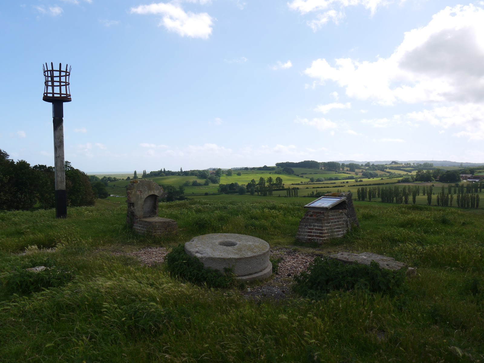
Site of Winchelsea Windmill

The hill itself had a prominence that far outweighed its height.  In Roman times the low lying land was full of seawater, although I suspect that it actually resembled a bit of a salt marsh and was affected greatly by the tides.  Now it is pasture and arable farmland for the most part and the former appearance can only be guessed at.  I suspect that the hill on which I was stood had a modest cliff line.  The path wound around the hill to appear back on the main road that I had crossed only a couple of hundred metres away.  In order to climb the hill, the A259 takes a tortuous route around the foot and via an enormous turn of almost 270 degrees.  I would not like to meet a double decker bus headed towards me on the bend!

Daily Commute

After my brief dalliance with the main road I headed along a country lane towards Winchelsea Station, more than a mile from the place it is meant to serve.  Probably for this reason the station has been downgraded somewhat and now only gets a service of half a dozen trains per day, with lengthy periods between them.  Not a very convenient way of getting to Winchelsea – I guess this is a ‘Parliamentary Service’ put on only to prevent the closure of the station rather than be of any real benefit to the passengers wanting to use it.  The station itself has also been rationalised, with the old station house now a private residence and that platform no longer in use.  Only a concrete open platform remains, although the railway staff have done their best to prettify it by putting some planters with flowers along its length.

Winchelsea Station

I continued along the lane until reaching a junction at the foot of what would have been the old cliff line at the far side of the valley.  The took a right at the wonderfully named Dumb Woman’s Lane – I’d love to know the provenance of that one!  I also had to take evasive action to avoid a large number of cyclists that were coming up behind me – they were also taking advantage of the small amount of good weather being enjoyed that day.

Former Cliff Line

I left the tarmac road as it headed up the hill and continued my course along the foot of the old cliff line.  This turned out to be a most agreeable section of walk – full of bird and butterfly life.  I wasn’t good enough to be able to capture any on film alas.  The constant light and shadow from the clouds scudding across the sky made for constantly different views and in this rather flat landscape the sky looked very big indeed!

Spider Meal
I had a happy moment as I approached a gate for in the opposite direction was an old gentleman, who looked to be on a similar mission to me, with his binoculars ready and camera poised.  We reached the gate simultaneously and shared a moment as we speculated on how coincidental that was when we were probably the only two walkers within a mile radius!

Rye Windmill

A little further on and in between the frustration of trying to photograph Red Admiral butterflies and rabbits running away hell for leather as I approached, I caught sight of a spider eating a hapless looking bee.  It wasn’t a spider in a web though but one cunningly camouflaged on a wild carrot flower.  An amazing sight that I had never seen before!

Swan Family
As I approached Rye I passed by a very unusual water treatment works – in fact it looked surprisingly grand for such a modest sized building.  Sadly it had been made vandal proof which had rather spoiled its good looks.  Above me was worse news though when a very large black cloud came overhead and rather spoiled my picture taking for a few minutes as it became rather dark.  Any notion of taking some pictures in Rye were rather dashed therefore and while I did linger for a short while at Rye Windmill, I decided that I would push on back towards Winchelsea rather than hang around for some more blue sky that might never come.

Looking Back to Rye


This ended my walk along the 1066 Country Walk – I have only the Bexhill and Hastings links to do now for this most agreeable little project.  It really does cover most of the main points of interest in this part of East Sussex, although if I am just a little critical of the route it would be that the Saxon Shore Way and 1066 Country Walk should swap routes between Rye and Winchelsea to make both walks a little more authentic for what they are respectively trying to achieve.

Guarding Camber Castle

Anyhow, I took the Saxon Shore Wayroute out of Ryeand headed through some very large sheep fields.  For most of the way to Camber Castlemy ears were full of the sound of bleating sheep, with the call of the lapwings that live in these parts accompanying them every so often.  It was a most peaceful evening besides that and despite the pretty good weather there were very few people about.  Before I got to Camber CastleI also had an encounter with a swan family that were getting pestered by some black headed seagulls.  I gave them a wide berth as they didn’t look too good tempered!
Royal Military Canal

By the time I reached Camber Castle, the large black cloud above me had dissipated and the castle was periodically lit up once again.  Camber Castlewas one of Henry VIII’s Device Forts, built to a similar design to others at Deal, Walmer, Southsea and Pendennis.  It was originally built to protect the Ryeanchorage, but since the retreat of the sea in these parts it now looks rather incongruous.  I was rather bemused to see that it now charges an entrance fee, which seemed a bit much considering that it is a mile from the nearest road and consists of only a ruin.  I hope English Heritage raise enough £3 entrance fees to make opening worthwhile, let alone have any money left over for renovations.  Anyhow, I wandered all round this fairly complete and lonely structure, fascinated by the enormous pits that have appeared in the stonework through 500 years worth of erosion.
Canal Crossing

By now the wind seemed to have whipped up more and the trees were blowing inside out and the clouds racing along as I re-approached Winchelsea.  I decided to walk along the Old Military Canal to the west end of Winchelsea so that I could re-enter the town through the New Gate and take another look at that in the sunlight rather than the driving rain I experienced last time.

New Gate
Walking along the canal was quite an experience.  I initially passed a young family trying their best to have a picnic hunkered down in the long grass.  Every so often a big black cloud looking like it would be full of rain would pass by and the path wasn’t the most pleasant to follow as it was quite overgrown.  I was glad to regain the road back through the New Gate and was pleasantly surprised when the sun reappeared properly for my triumphant entrance back into Winchelsea.

Wickham Manor View
On the way back into Winchelsea I saw many of the same sights that I had on the last stretch, but with the added bonus of seeing them in sunshine!  I did get a better look this time though of the house called Greyfriars, a large house built on the site of a former priory that was dissolved by Henry VIII during the Reformation.  Not much of the original priory is left for much of the stone was hauled away to build Camber Castle.  Priorities eh?  Sadly the glimpse of the house, which looks a rather grand affair, is all too fleeting and as you get closer to the house it is mostly obscured by trees.
Road into Winchelsea


I soon got back to Winchelsea to conclude my evening walk & a rather more pleasant walk it was too than trying to fight through the rain as was my prospect last time here!  The walk I followed would make for an excellent family walk, with plenty to see and learn about on the way.  I must admit to being a huge fan of this little corner of Sussex.  Sadly there is only one long distance walk I haven’t tried around here, so my excuses for coming will be soon run out…

Back to St Leonard's Church

Thursday, 7 June 2012

1066 Country Walk Section 3 Battle - Winchelsea


Battle Abbey

It has been almost a month since my last walk, with the brief spell of good weather coinciding with a busy time for me and the return of awful weather just as my calendar is free again L.  A glance at the weather forecast immediately following the Jubilee weekend suggested that I might be lucky if I headed to the east of the county, so with a full afternoon and evening at my disposal I thought I would have time to finish the 1066 Country Walk that I started a couple of years back with my wife.  We seem destined not to finish the walk together as the logistics are too difficult, so I decided this might be the best opportunity.

Battle Church
The weather on the way over to Battle wasn’t great, but the odd glimpse of sunshine through the clouds suggested that I might just get lucky.  I parked up at the station and within minutes the sun came out!  I decided that I would head to the town centre first to have another look since the last time I was here the weather wasn’t great.  The sun obliged this time and I managed a few decent shots before getting on my way.  Battle is quite a touristy town of course and one of the few places in England where it is commonplace to see signage in French as well as English, courtesy of its place in the respective histories of the two countries.  For it is here, rather than Hastings, where the real action of 1066 took place (hence the name of the walk!).  Battle Abbey is at the heart of the town, marking the point where the erstwhile King Harold lost his life in the famous Battle of Hastings.

Battle High Street
The high street of Battle is full of interesting shops but sadly suffers from far too much traffic.  I can remember this being a problem for as long as I can remember and even today on Wednesday lunchtime it was choked.  I didn’t linger too long, wanting to get some miles in while the weather was good.  According to the forecast I expected conditions to get better, but with all the rain around the country I couldn’t be certain.  The clouds certainly cleared away quickly as I left Battle along the flower lined Marley Lane, passing an old school built in the Dutch Style and looking as if it has recently been refurbished.  A little further on, past the level crossing, I passed the first oast house of the day, Blackfriars Oast.  As with many of these old places the oast house had been turned into the centrepiece of a grand home, a far cry from the original use of drying hops for the brewing industry.

Wildflower Bank
Just past the oast house and I headed off into the woods, initially along a squelchy path through what felt like a tree lined tunnel.  Once across the main stream at the bottom though the path opened out into a large ride through the trees and took a very straight route through Great Wood.  The going underfoot was rather easier and this section was really enjoyable as the sun popped out now and again, giving rise to some real warmth as it did so.  I wondered about the need for my rain coat and long walking trousers at such moments, but I kept them on just in case of a passing shower.

Great Wood Rhododendrons
The woods were full of wild flowers – inevitably the rhododendrons were the most obvious with their big blousy purple blooms, but also the show of common spotted orchids were pretty impressive too.  It was an enjoyable section of the walk so early in the day.  Eventually I came out into Seddlescombe Golf Course, which was curiously empty save for a couple of old ladies that seemed to have trouble hitting the ball more than a few yards.  Luckily they had a golf buggy on hand to try and speed things up, as if they were walking I fear they would still be on the course!


Clouds Breaking Up
Shortly after I passed through Norton Farm, the scene of the next oast houses and the first that I managed to get up close and personal with.  The cowl vane at the top were decorated with a farmer and horse drawn plough, a familiar adornment to these features.  The main house at the farm looked like it had been a victim of the ‘windows tax’ of a couple of hundred years ago but strangely the house didn’t look old enough.

Common Spotted Orchid
I crossed the main road just ahead and headed down a path to the side of a house that had a very annoying barking dog that seemed determined to ‘see me off’.  Meanwhile the path was a bit weed choked and my trousers soon got very wet from all the moisture that the vegetation had clung on to.  Thankfully the sun dried them off a bit, but I was glad that I hadn’t been tempted to remove the lower legs as I would surely have been very uncomfortable from stinging nettle rash.  The onward path continued through some wet meadows flushed with the bright yellow of buttercups and thronged with damsel flies buzzing around.  Despite my best efforts I had a hard time getting any pictures of them – I have come to realise that the new camera really doesn’t handle such shots very well.


A Good Drive Spoiled
I crossed another road and the route now seemed to definitely follow a small stream as it wound around the countryside.  This made for nice flat walking and was nice and easy going through fields of sheep and cattle that didn’t seem to bother me too much.  The path wound around the landscape a bit before finally making an entrance into the edge of the village of Westfield.  Houses in this section of the village were still sporting their Jubilee decorations from the weekend just passed.  I was just starting to enjoy the decorations when the path suddenly turned right and headed down into a dark valley below.  This was only a short cut though and I soon came up the other side of the valley into a separate part of the village.

Norton Farm
I popped down to the shop to get some refreshments before heading on.  I caught sight of a couple of scarecrows as I passed through the village & I remembered these from Battle a couple of years ago.  I guessed they were part of the same festival, although I was surprised not to have seen any before this.  The first was of a gold medal winning athlete, while the doctor’s surgery inevitably had a doctor and nurse outside.

Westfield Approaching
The path didn’t give a lot of opportunity to look at the village, heading out across fields and past the cricket pitch.  Given all the rain we have had I did wonder how much cricket they have managed so far this year?  Just the other side was Downoak Farm, complete with oast house.  This one had a cowl decorated by a group of lambs.  Across the way from the main farmhouse was a large house hidden behind a very overgrown looking garden that was starting to escape into the surrounding fields in the shape of some very lush looking rambling roses and honeysuckle.

Winning The Gold
My onward path took a rather unwelcome course across a rapeseed field, now virtually devoid of flowers.  The developing seed pods had intertwined, making for a very difficult route across this and the next field.  In fact the second field at the top of the hill seemed to have developed quicker than the first.  This made the field even more difficult to cross as the plants had drooped over under the weight of the seed pods.  The interlinking between the plants meant that it took all my strength to push through!  I was very pleased to make it through eventually and was pleased that these were the only two fields like it today.  I wandered through yet another farm and then passed a very beautiful chestnut tree with bright pink blossom rather than the usual white. 

Escaping Garden
Once past Pattleton’s Farm I got a view of sorts as I passed through a couple of sheep fields.  The view was of Doleham valley, with the outskirts of Hastings creeping over the hill in the distance.  I made my way to the bottom of the valley, where my path was joined by the link from Hastings.  This will be a future section, probably to finish this walk completely.  The signpost told me that it was 6 miles, while Icklesham, the next village en route was a couple of miles further on.  Shortly after I crossed the Marshlink Railway just south of Doleham station.  Any notion of breaking the journey here is now virtually impossible for this little remote station now receives little more than a ‘sulky service’ with trains only calling at rather impossible times of the day.  These are clearly not for the benefit of passengers, but just a means of ensuring that the station doesn’t have to be closed.  Almost immediately after I crossed the line a train ran past, something I couldn’t have planned better if I had tried!

Walking Through The Rapseseed
I climbed up and away from the railway getting a great view back across the countryside that I had walked across as I did so.  At the top was a secluded pond, a fairly common sight throughout the day.  I wondered whether they were dug to provide a water supply?  Certainly most of them were now unused for that purpose and indeed many were so surrounded with trees that it was impossible to believe that they had any use at all.

Pink Chestnut Blossom
I joined Doleham Lane and had a short stretch of road walking, passing the most remote post box I have seen for many years.  In fact it was difficult to understand why it was provided at all as Doleham was at the bottom of the hill and in any case only amounted to a dozen houses.  I continued around the lane enjoying the activity in the hedgerow including all manner of insects servicing the flowers and the odd rabbit scarpering into the undergrowth as soon as they caught sight of me.

Marshlink Train
I left the road at Lidham Hall and after passing the farm next door I came upon a conundrum when I reached the end of the track.  I faced five gates and no sign showing me the onward route!  Luckily after some scouting I discovered the signs were buried in the hedgerow and managed to get the right gate.  As soon as I opened it, the three horses in the field came galloping over to greet me.  I wasn’t sure whether they were friendly or not as they came sniffing round me, but as I tried to close the gate behind me they spooked and ran away almost as quickly as they had come.  I was certainly very wary of them as I crossed the field. 

Being Reclaimed by Nature
The path at the other end of the field was almost as difficult to find as the sign was hidden behind a bush.  Thankfully I made it through and wandered across a corner of Brede Level, which was suitably marshy.  I was pleased to resume a course of higher ground at the other end and was surprised at the rather stiff climb to the top through yet another farm.  As I passed through the farmyard the clouds, which had been thickening up for the last few minutes started to release the odd drop of rain.  This seemed to provoke a couple of lambs into action and they yelled as loudly as they could as I passed by.  I guess they thought I was the purveyor of bottle!

Icklesham Village Shop
The ridge walking was quite pleasant as I pushed along a stony track.  Icklesham, which was my next destination was now coming into view.  Along the ridge were some interesting sights including a commercial vehicle from the 1960s that looked as if it had been parked here for decades rather than years.  Nature was slowly reclaiming it, along with the junk that scattered the adjacent field.  Further on and I came upon a broad bean crop that had been picked and put in baskets but left abandoned by the side of the field.  It was all decidedly odd!  I passed through the latest farm and headed downhill once again crossing a small valley before ascending once again into Icklesham.  I had a small break half way up the other side of the hill, thinking that the rain was well and truly stopped now.  A quick check of the weather forecast suggested that the sun would return shortly.  I hoped so, for the finale of this walk looked quite promising…

The Duchess of Cornwall
I found the shop in Icklesham, although it wasn’t exactly where I expected it to be.  In fact it was rather unlike any other shop I have ever seen – it appears to be set up in the annexe of one of the houses along the main road!  The inside resembled one of those shops that you find on a camp site.  The choice of drinks wasn’t great but I took what I could get and hoped that this obviously new venture makes a go of things.  When I came out the spots of rain had come back.  I casually looked at the bus timetable on the offchance there might be one back to Hastings but discovered that I would have a 40 minute wait.  My weather forecast was still suggesting better things so I pressed on.  I continued on my way, passing another scarecrow – this time one dressed as the Duchess of Cornwall!

Icklesham Church
As I reached Icklesham Church the rain stopped and I had a good look around the church yard.  The church itself seemed rather shy, being completely surrounded by trees and not really visible from outside the churchyard.  I pushed on, seeing the rather strange sight of a woman pushing a mobile clothes hanger along the path towards me, the kind you might see in a clothes shop.  It looked rather awkward and I offered help but she declined politely in a strong Italian sounding accent.  Not something you encounter very often & all rather surreal.

Icklesham Mill
The rain started coming back, a few drops at first but after a few minutes it got steadily heavier.  I passed by a field with some very distinctive markings – especially their black bottoms!  They seemed to have aroused the curiosity of a couple of young girls, who were taking lots of pictures of them and were completely immersed in what they were doing.  They certainly weren’t dressed for rain!  As I approached Icklesham windmill the rain got heavier still and by now I was getting quite wet.  Sadly I didn’t have the inclination to pause to look at the windmill in any detail and continued my journey to the road ahead.  I paused under the trees for a few minutes and consulted the weather forecast, which stubbornly suggested that we were due bright sunshine within the next couple of hours.

Winchelsea New Gate
When the rain eased a little I pushed on, through a field full of rabbits and then some nervous looking bullocks.  They looked as fed up as I felt especially as it was clear to me now that the rain had set in for some time.  I passed Wickham Manor, a wonderful looking old building and down to Winchelsea New Gate.  This curious edifice is all that remains of the town walls of this ancient town, one of the original Cinque Ports.  It was difficult to enjoy all this though as the rain continued to come down heavily.  When I got to Winchelsea proper I took a quick look around the old church yard and then decided that I would simply wait for the next bus, with no prospect of the weather getting any better.  From what I had seen since Icklesham, I felt this section deserved far better attention than I was able to give it and decided therefore to abort and come back on a more benign day when I could look around properly.  There certainly didn’t seem much point in pushing on to Rye for the end of the walk.

Winchelsea Church
Thus I had a frustrating end to the day, but the bus and train combination back to Battle worked pretty well and by the time I got back to Worthing the sun was out again!  I shall be back for more of this route – perhaps to try my luck from Hastings rather than Battle.  The last section from Icklesham in particular looked very interesting!

Monday, 9 August 2010

1066 Country Walk Section 2 Boreham Street - Battle

Boreham Street
After a false start on this walk a couple of weeks earlier (we forgot the map, so had to retrace the first section in reverse!) my wife and I managed to find another spare day without children (both were at school) to undertake the eight miles between Boreham Street and Battle.  As with the last section of the walk public transport would be a bit convoluted so we parked at Bexhill station and took the bus over to Boreham Street.  Being a Tuesday the village was deserted when we got off the bus, the only sign of life being the cars travelling through at great speed.  If I’m honest the road rather spoils the appearance of the village, which would otherwise be a very pleasant and peaceful place.
Which Way?

We wandered along the road to the eastern edge of the village and were quite pleased when we crossed the fence and entered open countryside at last.  Since our last trip on this walk the countryside was beginning to have an end of summer look about it.  Greens were giving way to golds and late summer flowers were coming into season.  The countryside ahead looked rather different from the Pevensey Levels behind us.  Now we would be crossing an undulating landscape of ancient woodland and fields of barley and wheat rather than the fields full of livestock that characterise the marsh country.  Everything seemed less anxious than earlier in the summer, the bumble bees seemed bumblier and the butterflies lingered over each flower.  In a sense the ordinariness of the countryside made us more aware of our immediate surroundings rather than be wowed by the views.
Little Red Tractor

It was a sticky sort of day with a lot of cloud that stubbornly refused to move.  This made progress harder work than it should have been, for any extended effort quickly brought about a raging thirst and sweatiness, part of the reason why I dislike summer walking in the daytime.  We passed by a farm that had diversified by converting outbuildings into holiday lets (and yet kept a building full of redundant machinery – to be turned into a museum?) before meeting a road.  We were to follow this road for some time, from Wilson’s Cross through the hamlet of Bray’s Hill to the wonderfully named Brownbread Street.  The road wasn’t particularly pleasant walking although it was thankfully pretty quiet and we didn’t have to contend with too much traffic.  A postman out on his rounds passed us a couple of times and we mused about how pleasant his job must be, bombing around the country lanes and delivering letters and parcels to the fairly scattered community in this part of The Weald.
Lunch Stop

When we reached Brownbread Street I was surprised to see a windmill though the trees by the side of the road.  I wasn’t able to get a good look at it as it was shielded from the road, but it wasn’t marked on the map which I found a little strange (later I discovered that this windmill is actually a fake and serves only to decorate a pony sanctuary).  Just along from the windmill there was an old fashioned barn with what looked like the children’s TV character, The Little Red Tractor’ poking its nose out of the open doors.  It was left chugging, but there was no-one in evidence ready to take it out for a spin.  By now it was approaching mid-day and the pub next door looked very enticing, especially since the next available stop wouldn’t be until Catsfield, a good hour and a half away.  We had some doubts that the Catsfield pub would be open since I had read a news report earlier in the day that the place had been robbed overnight (http://www.bbc.co.uk/news/uk-england-sussex-10694232). 
Iron Stream

However, the wait at the Ash Tree Inn was worth it.  We had a lovely lunch, proper home cooked fare and a pint of real ale to wash it down.  This is a recommended refreshment stop en route!  Initially we had the garden to ourselves but soon the pub began to fill up with customers and turned out to be quite busy by the time we left at 1pm.  Surprising for a Tuesday lunchtime, but it obviously has a local reputation for good food.

One Tree or Many?

Bellies full, we gingerly continued on our way along the road for about half a mile more before crossing a field.  Any thoughts of leaving roads behind us were short lived though as we resumed the road walking on the other side of the field for almost another mile.  We headed downhill initially, passing an old watermill in the trees and an entrance to Ashburnham Park which looked like a grand landscaped estate.  There followed a short climb, which proved quite difficult with full tummies before crossing a number of fields down to another fast flowing stream.  This was stained red with iron oxide, possibly as a result of former industrial uses.  After crossing the small footbridge we climbed up the appropriately named Tent Hill (it did resemble the shape of a tent).  The summit proved to be a false one, for we kept climbing for some time beyond the supposed crest of the hill.  Away in the distance we could see the almost hidden village of Penhurst among the trees.  For a modestly sized hill it had a surprisingly good view, with Ashburnham Place also quite evident to the southwest of our position.
Latin

As we continued climbing we passed what at first looked like a copse but on closer inspection we soon realised that it was an enormous horse chestnut tree.  Inside its crown was cavernous and would probably afford some pretty good shelter in a rainstorm (so longer as lightning isn’t a factor!).  We continued across what was billed as a deer park on the map, but no deer were in evidence today.  Eventually we reached the hamlet of Steven’s Crouch and a rather nasty road crossing.  On the other side of the road the character of the walk changed once again as we headed through large tracts of woodland for the next couple of miles to Catsfield. 
Catsfield Pond

When we reached Catsfield our thoughts turned towards the horrible ordeal that the landlord of the pub must have suffered the night before.  We availed ourselves of the village shop since the pub was inevitably closed.  As we continued through the village we were very struck by the picture postcardness of some of the individual houses.  As a village though, it too suffers from heavy traffic passing through.
Chocolate Box Cottage

We left the village via a field that enabled us to cut off a road corner before crossing it and heading into open countryside once more.  Within a couple of minutes we were heading through a forest of Christmas trees and weren’t sure whether or not this was a farm.  The remaining part of the walk was along farm tracks and as we got closer towards Battle we speculated about how the scene must have looked when the most famous of all British battles took place in 1066.  Stragglers from the battle would probably have continued skirmishing far beyond the primary battlefield.  We also met the link path coming from Bexhill just before reaching Battle itself, which suddenly snuck up on us.  The path came out just by the entrance to Battle Abbey, said to have been built on the very spot that the hapless King Harold was struck in the eye by the arrow.
Battle Abbey

Even on a midweek day outside the school holidays Battle was rammed with tourists and all the eating and drinking establishments outside the Abbey were full of people refreshing themselves after the exertions of sightseeing.  For us we still had a little way to go as Battle station is not at all convenient for the town and we faced another half mile or so walk out past the church and down to the south east corner of Battle to find the train back to Bexhill.  No direct connection is now possible thanks to Dr Beeching, who closed the direct line to Bexhill West.  By connecting at St Leonards Warrior Square, we were still back in Bexhill a little more than twenty minutes later (courtesy of a very tight connection).
Battle Church

This part of the 1066 Country Walk is not as interesting as the first section, but with the pub lunch stop, it made for a pleasant outing.  Battle serves as a good place to stop and has much to recommend it as a place to look around.  For this reason I would recommend splitting what would be a long first day (15 miles) into two shorter sections so that you still have enough energy to give Battle the attention it deserves.  Boreham Street is probably the most convenient break point if you do decide to split the first section, as we did.