|
| Cinder Track |
When we decided to go to Whitby for our Whitsun holiday I did think it would be fun to take the children cycling along an old railway for the first time and was pleased that we found a bike hire place at Hawsker so we didn't have to lug our own bikes there. It wasn't particularly cheap though - probably the most I have ever paid for a day's bike hire. The hire place is based at the old station at Hawsker.
 |
| Hawsker Station |
The Whitby to Scarborough Railway was opened in 1885 towards the end of the railway building era and lasted until the Beeching cuts of the 1960s, eventually succumbing in 1965. In truth it wasn't ever likely to survive due to the operational difficulties that the railway companies had. It was built fairly cheaply and had some steep gradients along its length. Perhaps the most difficult aspects though were the connections at each end of the line where trains had to be reversed to enter the stations at Scarborough and Whitby, disrupting other services considerably in the process.
 |
| Down Into Whitby |
With this being the girls' first experience of riding such a route we decided to go towards Whitby to begin with as I thought that this would be a quieter prospect. It would also give us the opportunity to take a look at one of the most impressive engineering features on the whole line, the 13 arch brick viaduct that spans the River Esk. The route from Hawsker is largely downhill and this provided an opportunity for the girls to get used to the new bikes without too much difficulty. What I hadn't banked on was the steepness of the descent. One imagines that railway lines are largely flat but in my experience some of these closed lines actually have quite steep gradients, as in this case. It was quite exhilarating riding down into Whitby and some of the views along the way were quite memorable. This is not a railway largely confined to a tree lined tunnel.
 |
| Larpool Viaduct View East |
At the bottom of the hill we stopped at Larpool Viaduct and admired the view across to Whitby Abbey. Both structures are mentioned in Bram Stoker's famous novel Dracula and we had had that on in the car for the duration of the holiday. The trail goes on a little way further towards the former station at Whitby West Cliff but we didn't venture further on. By now the day was warming up considerably and the ride back to Hawsker was quite tiring. When we met a very large rambling group three quarters of the way back we were happy to stop and wait for them to pass by so we could have a breather.
 |
| Larpool Viaduct View West |
Hawsker station has been restored beautifully and hosts a couple of railway carriages that act as offices for the cycle hire business but also as rather novel places to stay. Holiday accommodation of this nature used to be quite commonplace and it is good to see this tradition maintained here.
 |
| Whitby Abbey From Larpool |
Any thoughts that Hawsker would be the top of the hill were soon dispelled however as the old line kept climbing. It was also quite narrow in places, largely because the original track formation was only a single line and with encroachment from vegetation we sometimes only had the width of cycle + rider to work with. Just beyond Hawsker we crossed the road via a pedestrian crossing. When the railway was operational this would have been crossed underneath the road and frankly it would be very welcome if that style of crossing could be restored, for both drivers and cyclists.
 |
| Chugging Through Hawsker Station |
The line continued
to head uphill for a further half mile or so. As we climbed the view
back towards Whitby opened up and a mighty fine view it was. At the top
we crossed a smaller road the track widened considerably as we passed
through a shallow cutting. The surface though was not agreeable. The
line is now known as the cinder track due to the nature of the surface
but here the cinder pieces were quite big and that led to rather a rough
ride for a while. Further on we turned away from Whitby for good and
had a new perspective on the coast. For railway passengers this must
have been delightful to travel. On a warm early summer's day by bike it
was a pleasure too and soon the line began to descend again this time
for quite a long way down into Robin Hood's Bay, the next station on the
line.
 |
| Orchids |
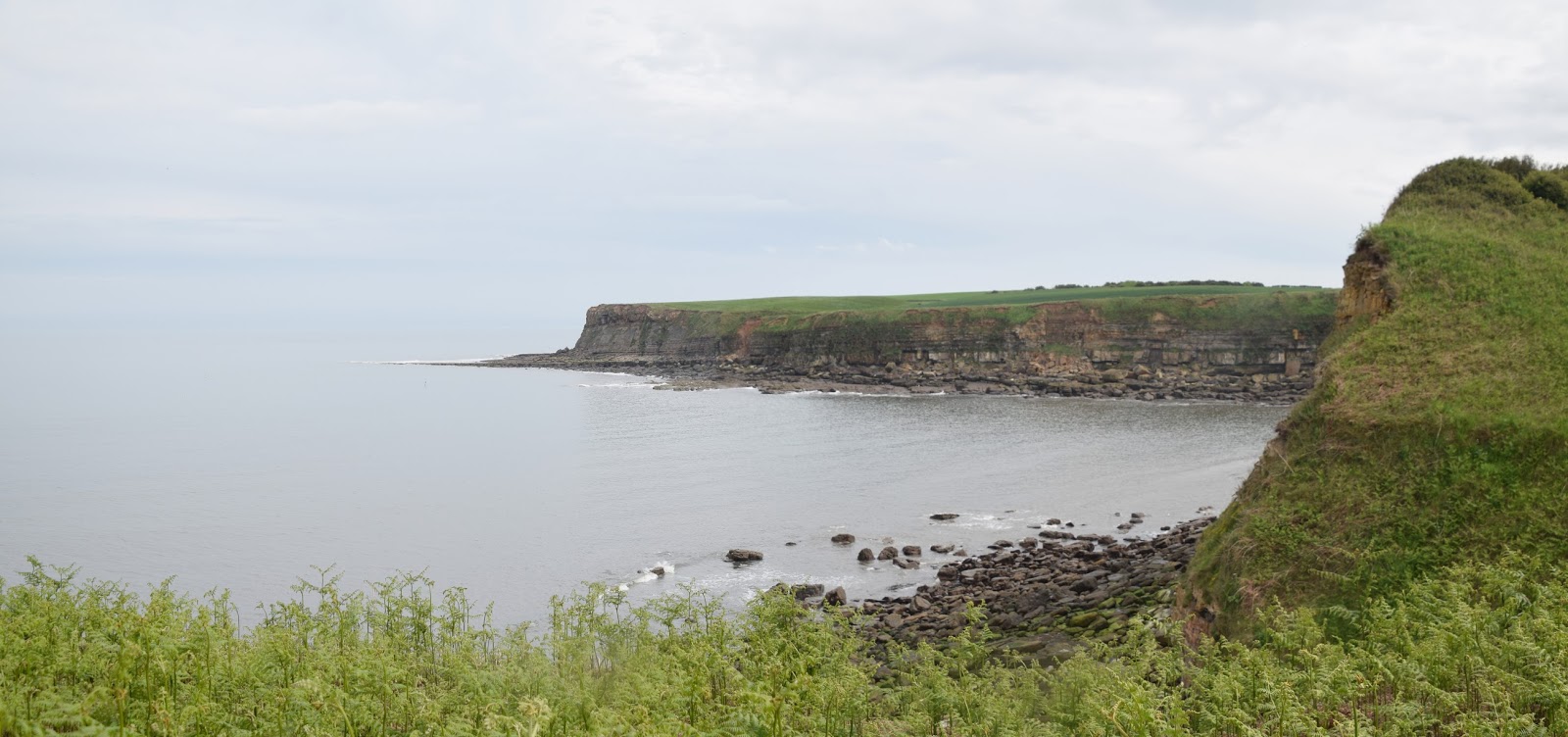
As we rounded the coast the view across the bay was quite magnificent. The gradient got a lot steeper too and it wasn't difficult to imagine the struggles of the trains coming along this route. I don't remember a railway line with such steep gradients (with the possible exception of the High Peak Trail in Derbyshire - but that had inclines) and I certainly wasn't looking forward to the return journey.
 |
| Approaching Robin Hood's Bay |
We got to Robin's Hood Bay in time for lunch. The track ran out as the houses started; it plots a course through the housing and crossed the road although the bridge is now missing. There is a large car park in the area that was once the station yard and we left our bikes there while we explored the town and the beach. I hadn't been here since I was a boy but it was pleasing to see how little had changed from how I remembered it. The only thing that was different was the amount of visitors - the place was rammed. We spent a good deal of time on the beach as it was low tide and the children really enjoyed looking in all the rock pools. I watched one in particular and was rewarded when I saw a very large crab wandering along trying to stay out of sight by hiding in the seaweed.
 |
| Robin Hood's Bay Station |
After a lengthy break we got back on our bikes at Robin Hood's Bay Station and headed on towards Ravenscar. The station itself is intact and looking in splendid condition as a set of holiday accommodations. I think it would be a great place to base ourselves if we came again. The track proper recommenced further on after crossing a main road and we soon resumed the winding track. Now the track was more wooded and there were only brief glimpses of the surrounding countryside. We were noticeably going uphill too - this was something we had to contend with all the way to Ravenscar. We passed by a farm and a caravan site and I wondered where it was that we camped when I was a boy - it was around here somewhere. Too many years have passed though for me to remember.
 |
| Narrow Streets |
As we got towards Fyling Hall Station a couple of the bridges had been removed and we had to cross roads. I always find this slightly annoying on railway lines. The short term gain of the scrap value of the bridges mean that we all have to pay decades later. Fyling Hall Station is still just about intact although I had to pay attention for the erstwhile platforms are being absorbed back into nature. The station masters house is in rude health though and it is that which you should look out for to give you a clue about the platforms.
 |
| Robin Hood's Bay From Beach |
We crossed more roads and continued our plod uphill. The line was becoming more rural than ever now and it is interesting that this is the only route that directly linked Robin Hood's Bay with Ravenscar. All the roads head inland and it is quite a lot further between the two settlements by road than it ever was by rail. The 13 minute rail journey has now been replaced by a bus journey requiring one change and taking more than an hour. That's progress?
 |
| Robin Hood's Bay Beach |
The route gradient increased markedly as we got closer to Ravenscar before the trackbed is left for a short stretch while the line heads through a tunnel (this is off limits). Apparently trains used to often struggle when they got to the tunnel as the climb up here was 1 in 39 and engines would stall as they git inside the tunnel. We continued on to the station which is clearly visible although only the down platform remains. What is more remarkable is the station approach. This is a grandly laid out square, upon which there is a set of buildings that hint at something grander following their construction.
 |
| Sustrans Pointer |
In fact Ravenscar is often billed as the town that never was. Back at the turn of the 20th Century developers laid out plans for a much larger town and streets and infrastructure was laid out. Much of the speculation did not materialise though as the trek down to the rocky beach deterred visitors who preferred other nearby places. Developers never built the buildings that would have ensured the growth of the town and it was left as a backwater. It is a most curious place to wander round now as a result.
 |
| Fyling Hall Station |
At Ravenscar we headed back. It is possible to continue on the Cinder Track all the way to Scarborough but none of us had the energy to proceed and in any event we were on a timescale with the hired bikes. We also remembered that the way back was going to be quite a slog especially leaving Robin Hood's Bay. We had slow progress going back but the girls had a thoroughly good time and I have no doubt that we will be doing something similar again in the near future.
 |
| Ravenscar |