Thursday, 7 June 2012

1066 Country Walk Section 3 Battle - Winchelsea


Battle Abbey

It has been almost a month since my last walk, with the brief spell of good weather coinciding with a busy time for me and the return of awful weather just as my calendar is free again L.  A glance at the weather forecast immediately following the Jubilee weekend suggested that I might be lucky if I headed to the east of the county, so with a full afternoon and evening at my disposal I thought I would have time to finish the 1066 Country Walk that I started a couple of years back with my wife.  We seem destined not to finish the walk together as the logistics are too difficult, so I decided this might be the best opportunity.

Battle Church
The weather on the way over to Battle wasn’t great, but the odd glimpse of sunshine through the clouds suggested that I might just get lucky.  I parked up at the station and within minutes the sun came out!  I decided that I would head to the town centre first to have another look since the last time I was here the weather wasn’t great.  The sun obliged this time and I managed a few decent shots before getting on my way.  Battle is quite a touristy town of course and one of the few places in England where it is commonplace to see signage in French as well as English, courtesy of its place in the respective histories of the two countries.  For it is here, rather than Hastings, where the real action of 1066 took place (hence the name of the walk!).  Battle Abbey is at the heart of the town, marking the point where the erstwhile King Harold lost his life in the famous Battle of Hastings.

Battle High Street
The high street of Battle is full of interesting shops but sadly suffers from far too much traffic.  I can remember this being a problem for as long as I can remember and even today on Wednesday lunchtime it was choked.  I didn’t linger too long, wanting to get some miles in while the weather was good.  According to the forecast I expected conditions to get better, but with all the rain around the country I couldn’t be certain.  The clouds certainly cleared away quickly as I left Battle along the flower lined Marley Lane, passing an old school built in the Dutch Style and looking as if it has recently been refurbished.  A little further on, past the level crossing, I passed the first oast house of the day, Blackfriars Oast.  As with many of these old places the oast house had been turned into the centrepiece of a grand home, a far cry from the original use of drying hops for the brewing industry.

Wildflower Bank
Just past the oast house and I headed off into the woods, initially along a squelchy path through what felt like a tree lined tunnel.  Once across the main stream at the bottom though the path opened out into a large ride through the trees and took a very straight route through Great Wood.  The going underfoot was rather easier and this section was really enjoyable as the sun popped out now and again, giving rise to some real warmth as it did so.  I wondered about the need for my rain coat and long walking trousers at such moments, but I kept them on just in case of a passing shower.

Great Wood Rhododendrons
The woods were full of wild flowers – inevitably the rhododendrons were the most obvious with their big blousy purple blooms, but also the show of common spotted orchids were pretty impressive too.  It was an enjoyable section of the walk so early in the day.  Eventually I came out into Seddlescombe Golf Course, which was curiously empty save for a couple of old ladies that seemed to have trouble hitting the ball more than a few yards.  Luckily they had a golf buggy on hand to try and speed things up, as if they were walking I fear they would still be on the course!


Clouds Breaking Up
Shortly after I passed through Norton Farm, the scene of the next oast houses and the first that I managed to get up close and personal with.  The cowl vane at the top were decorated with a farmer and horse drawn plough, a familiar adornment to these features.  The main house at the farm looked like it had been a victim of the ‘windows tax’ of a couple of hundred years ago but strangely the house didn’t look old enough.

Common Spotted Orchid
I crossed the main road just ahead and headed down a path to the side of a house that had a very annoying barking dog that seemed determined to ‘see me off’.  Meanwhile the path was a bit weed choked and my trousers soon got very wet from all the moisture that the vegetation had clung on to.  Thankfully the sun dried them off a bit, but I was glad that I hadn’t been tempted to remove the lower legs as I would surely have been very uncomfortable from stinging nettle rash.  The onward path continued through some wet meadows flushed with the bright yellow of buttercups and thronged with damsel flies buzzing around.  Despite my best efforts I had a hard time getting any pictures of them – I have come to realise that the new camera really doesn’t handle such shots very well.


A Good Drive Spoiled
I crossed another road and the route now seemed to definitely follow a small stream as it wound around the countryside.  This made for nice flat walking and was nice and easy going through fields of sheep and cattle that didn’t seem to bother me too much.  The path wound around the landscape a bit before finally making an entrance into the edge of the village of Westfield.  Houses in this section of the village were still sporting their Jubilee decorations from the weekend just passed.  I was just starting to enjoy the decorations when the path suddenly turned right and headed down into a dark valley below.  This was only a short cut though and I soon came up the other side of the valley into a separate part of the village.

Norton Farm
I popped down to the shop to get some refreshments before heading on.  I caught sight of a couple of scarecrows as I passed through the village & I remembered these from Battle a couple of years ago.  I guessed they were part of the same festival, although I was surprised not to have seen any before this.  The first was of a gold medal winning athlete, while the doctor’s surgery inevitably had a doctor and nurse outside.

Westfield Approaching
The path didn’t give a lot of opportunity to look at the village, heading out across fields and past the cricket pitch.  Given all the rain we have had I did wonder how much cricket they have managed so far this year?  Just the other side was Downoak Farm, complete with oast house.  This one had a cowl decorated by a group of lambs.  Across the way from the main farmhouse was a large house hidden behind a very overgrown looking garden that was starting to escape into the surrounding fields in the shape of some very lush looking rambling roses and honeysuckle.

Winning The Gold
My onward path took a rather unwelcome course across a rapeseed field, now virtually devoid of flowers.  The developing seed pods had intertwined, making for a very difficult route across this and the next field.  In fact the second field at the top of the hill seemed to have developed quicker than the first.  This made the field even more difficult to cross as the plants had drooped over under the weight of the seed pods.  The interlinking between the plants meant that it took all my strength to push through!  I was very pleased to make it through eventually and was pleased that these were the only two fields like it today.  I wandered through yet another farm and then passed a very beautiful chestnut tree with bright pink blossom rather than the usual white. 

Escaping Garden
Once past Pattleton’s Farm I got a view of sorts as I passed through a couple of sheep fields.  The view was of Doleham valley, with the outskirts of Hastings creeping over the hill in the distance.  I made my way to the bottom of the valley, where my path was joined by the link from Hastings.  This will be a future section, probably to finish this walk completely.  The signpost told me that it was 6 miles, while Icklesham, the next village en route was a couple of miles further on.  Shortly after I crossed the Marshlink Railway just south of Doleham station.  Any notion of breaking the journey here is now virtually impossible for this little remote station now receives little more than a ‘sulky service’ with trains only calling at rather impossible times of the day.  These are clearly not for the benefit of passengers, but just a means of ensuring that the station doesn’t have to be closed.  Almost immediately after I crossed the line a train ran past, something I couldn’t have planned better if I had tried!

Walking Through The Rapseseed
I climbed up and away from the railway getting a great view back across the countryside that I had walked across as I did so.  At the top was a secluded pond, a fairly common sight throughout the day.  I wondered whether they were dug to provide a water supply?  Certainly most of them were now unused for that purpose and indeed many were so surrounded with trees that it was impossible to believe that they had any use at all.

Pink Chestnut Blossom
I joined Doleham Lane and had a short stretch of road walking, passing the most remote post box I have seen for many years.  In fact it was difficult to understand why it was provided at all as Doleham was at the bottom of the hill and in any case only amounted to a dozen houses.  I continued around the lane enjoying the activity in the hedgerow including all manner of insects servicing the flowers and the odd rabbit scarpering into the undergrowth as soon as they caught sight of me.

Marshlink Train
I left the road at Lidham Hall and after passing the farm next door I came upon a conundrum when I reached the end of the track.  I faced five gates and no sign showing me the onward route!  Luckily after some scouting I discovered the signs were buried in the hedgerow and managed to get the right gate.  As soon as I opened it, the three horses in the field came galloping over to greet me.  I wasn’t sure whether they were friendly or not as they came sniffing round me, but as I tried to close the gate behind me they spooked and ran away almost as quickly as they had come.  I was certainly very wary of them as I crossed the field. 

Being Reclaimed by Nature
The path at the other end of the field was almost as difficult to find as the sign was hidden behind a bush.  Thankfully I made it through and wandered across a corner of Brede Level, which was suitably marshy.  I was pleased to resume a course of higher ground at the other end and was surprised at the rather stiff climb to the top through yet another farm.  As I passed through the farmyard the clouds, which had been thickening up for the last few minutes started to release the odd drop of rain.  This seemed to provoke a couple of lambs into action and they yelled as loudly as they could as I passed by.  I guess they thought I was the purveyor of bottle!

Icklesham Village Shop
The ridge walking was quite pleasant as I pushed along a stony track.  Icklesham, which was my next destination was now coming into view.  Along the ridge were some interesting sights including a commercial vehicle from the 1960s that looked as if it had been parked here for decades rather than years.  Nature was slowly reclaiming it, along with the junk that scattered the adjacent field.  Further on and I came upon a broad bean crop that had been picked and put in baskets but left abandoned by the side of the field.  It was all decidedly odd!  I passed through the latest farm and headed downhill once again crossing a small valley before ascending once again into Icklesham.  I had a small break half way up the other side of the hill, thinking that the rain was well and truly stopped now.  A quick check of the weather forecast suggested that the sun would return shortly.  I hoped so, for the finale of this walk looked quite promising…

The Duchess of Cornwall
I found the shop in Icklesham, although it wasn’t exactly where I expected it to be.  In fact it was rather unlike any other shop I have ever seen – it appears to be set up in the annexe of one of the houses along the main road!  The inside resembled one of those shops that you find on a camp site.  The choice of drinks wasn’t great but I took what I could get and hoped that this obviously new venture makes a go of things.  When I came out the spots of rain had come back.  I casually looked at the bus timetable on the offchance there might be one back to Hastings but discovered that I would have a 40 minute wait.  My weather forecast was still suggesting better things so I pressed on.  I continued on my way, passing another scarecrow – this time one dressed as the Duchess of Cornwall!

Icklesham Church
As I reached Icklesham Church the rain stopped and I had a good look around the church yard.  The church itself seemed rather shy, being completely surrounded by trees and not really visible from outside the churchyard.  I pushed on, seeing the rather strange sight of a woman pushing a mobile clothes hanger along the path towards me, the kind you might see in a clothes shop.  It looked rather awkward and I offered help but she declined politely in a strong Italian sounding accent.  Not something you encounter very often & all rather surreal.

Icklesham Mill
The rain started coming back, a few drops at first but after a few minutes it got steadily heavier.  I passed by a field with some very distinctive markings – especially their black bottoms!  They seemed to have aroused the curiosity of a couple of young girls, who were taking lots of pictures of them and were completely immersed in what they were doing.  They certainly weren’t dressed for rain!  As I approached Icklesham windmill the rain got heavier still and by now I was getting quite wet.  Sadly I didn’t have the inclination to pause to look at the windmill in any detail and continued my journey to the road ahead.  I paused under the trees for a few minutes and consulted the weather forecast, which stubbornly suggested that we were due bright sunshine within the next couple of hours.

Winchelsea New Gate
When the rain eased a little I pushed on, through a field full of rabbits and then some nervous looking bullocks.  They looked as fed up as I felt especially as it was clear to me now that the rain had set in for some time.  I passed Wickham Manor, a wonderful looking old building and down to Winchelsea New Gate.  This curious edifice is all that remains of the town walls of this ancient town, one of the original Cinque Ports.  It was difficult to enjoy all this though as the rain continued to come down heavily.  When I got to Winchelsea proper I took a quick look around the old church yard and then decided that I would simply wait for the next bus, with no prospect of the weather getting any better.  From what I had seen since Icklesham, I felt this section deserved far better attention than I was able to give it and decided therefore to abort and come back on a more benign day when I could look around properly.  There certainly didn’t seem much point in pushing on to Rye for the end of the walk.

Winchelsea Church
Thus I had a frustrating end to the day, but the bus and train combination back to Battle worked pretty well and by the time I got back to Worthing the sun was out again!  I shall be back for more of this route – perhaps to try my luck from Hastings rather than Battle.  The last section from Icklesham in particular looked very interesting!

Friday, 25 May 2012

Sussex Border Path Section 14 Rusper and Charlwood

Rusper Church

 It has been a frustrating time since my birthday, with the odd opening in my calendar for walking dashed by the worst April conditions I can remember. Knowing that the next section of the Sussex Border Path was likely to be muddy, I decided that only the best weather would entice me out on to this part of the walk. Fortunately, last Sunday presented just such a day and I headed out very early to Rusper to carry on from where I had left off on that snowy day back in February.


Misty Morning

It was just before 7am when I got going and the weather was picture perfect as I parked outside Rusper church. The village was deserted but within seconds of getting my boots on a large and posh looking car drew up with a couple of foreign tourists asking me where they might find a coffee shop! Being deepest rural Sussex I did think they would be out of luck this early on a Sunday morning so I pointed them to Horsham as being the nearest place that might offer something.


Bluebell Season

Last time out on this walk I had hoped to include Rusper but hadn’t managed to on account of the fading light. My first priority therefore was to complete the short loop by the Royal Oak at Friday Street. I found a path at the south end of the village and headed that direction. This was across open fields and conditions weren’t as bad as I had previously feared. Given the early morning the sunlight wasn’t strong enough quite yet to burn off the mist and this part of the walk was characterised by the swirling patterns created as a result.


Blue Carpet

After about half an hour I passed by the Royal Oak, where I had left off last time and joined the official route back to Rusper. I soon realised that my outward journey was not going to be typical of the conditions I was likely to encounter today. Almost immediately the way forward through the woods turned into a mud bath, making walking conditions extremely difficult. The woodland floor was still carpeted with bluebells in places, while ramsons (also known as wild garlic) were also very much in evidence. Colonies of these plants generally denote ancient woodlands, and given the steep sides of the valley running through the wood it is easy to imagine this area never having lost its tree cover.


The Royal Oak

Eventually I left the woodland behind and for a time I lost the sun completely as the mist had gathered together into large clouds. It was a strange looking phenomenon and disappeared almost entirely within minutes to be replaced by blue skies once again by the time I got back to Rusper church. I crossed the road and headed off across fields, squelching through the mud as I went. As I headed off towards Charlwood, the roar of the planes taking off from Gatwick became ever louder as I approached the airport.

Red Rhododendrons


Another woodland section of walk soon beckoned and while I did appreciate the bird song and the freshly sprouting leaves it was difficult to give these my full attention as I slithered my way along the muddy paths. In fact, how I kept my feet was a miracle in itself. The only near miss I had in terms of going completely over was when I had a brief encounter with a deer as it scarpered away at top speed when it heard me coming. The bird song was quite insistent in the trees, like a chaotic woodwind section of an orchestra. A distant woodpecker did his part too, knocking some percussive beat every so often. I cursed the mud, for above me everything was great now that the day was properly getting underway.


Misty Gateway

Eventually I had a brief respite from the mud when a short section of road walking was thrown into the mix. I passed a substantial house, built with a very striking looking tower, and then headed over a stile to be met by what I can only describe as a swamp. That should have told me not to bother proceeding across the field ahead, for the whole field was completely waterlogged and wandering across was a complete nightmare. I got spooked halfway across when I saw some large flightless birds wandering across the field towards me. They weren’t ostriches – perhaps rheas or emus? It was difficult to tell and I gave them a wide berth as I had no desire to be pecked either as a result of inquisitiveness or annoyance! I think they were probably put there to fend off would be sheep rustlers – they certainly would have made me think twice about taking one of the sheep out of the same field!


Ramsons

I had a bit of a hard time figuring out the line of the path across these fields and started heading off in the wrong direction. Fortunately a distant farm hand pointed me in the right direction and I soon picked up the rather sparse signage once again. I came out of the field by a large hotel, a rather ugly looking place from the angle I was looking from. The entrance suggested a rather better looking building from the front view and there was a large coach load of tourists ready to head off, suggesting that it caters for a certain clientele? In this area of low hills, it did look to have something of a view across to the airport in the distance and I could just about see the planes actually taking off.

Hawthorn


The path followed the road for a short while before heading off across fields for the last leg into Charlwood.  I decided to stick with the road since I was very interested to take a look at Lowfield Heath windmill.  This old post mill wasn’t originally sited here, but was in the way of Gatwick Airport a little to the south.  It was moved in 1987, nearly 250 years after it was built in its original location.  The rest of the village wasn’t so lucky – it was demolished to make way for hangars and warehouses associated with the airport.
Turret


It was still pretty early when I got to the windmill and the volunteers were just rolling up for their big day ahead.  It was National Mills Day and they were expecting quite a few visitors later on to help them celebrate.  I was allowed exclusive access to look around, which was very much appreciated.  The mill had been newly painted outside with some new sails also fixed on.  The mill looked radiant in the early morning sunshine.  It was well worth the detour to take a closer look!


Rheas

A little further on and I came upon the church of St Nicholas at the southern edge of the village of Charlwood.  Somewhere along the way I had edged into Surrey again – the village of Charlwood being in Surrey but originally intended for West Sussex when local government reorganisation took place in 1974.  The church was Norman but apparently had been enlarged significantly during the Fifteenth Century.  Because of my extremely muddy boots I didn’t venture inside but admired the very old looking yew trees in the churchyard and even spotted my first orange tip butterfly of the spring.  Sadly it was too shy for a decent photo as usual (never managed a good shot of one).

Charlwood Mill


I pushed on into the village and was relieved to find that the local shop was open for by now I was parched and the weather was getting really quite hot.  I grabbed a cold one and ended my section on the official part of the path here.  For now I just had to find my way back to Rusper across the fields.  My path out of Charlwood wasn’t great as I headed south past the end of the Gatwick runway.  More extreme mud and I had a double dose when I dropped the map and didn’t discover it for half a mile.  How I cursed!

Charlwood Church

The path across the end of the Gatwick Airport runway was most strange.  Every couple of minutes the huge jets thundered down the runway and took off so close that I almost felt as if I could touch them!  A few of the newer and quieter jets seemed to need a lot less run up than the older ones and they took off at a much steeper angle it seemed.  It was a noisy but fascinating path.  At the other end of the field a plane spotter was busy recording the various aircraft taking off and jotting down notes in his book.  He was too intent with what he was doing to be interested in me.


Reflections

Beyond the end of the field the path entered an enclosed section between woodland and field, fenced on both sides.  All was well initially but within a coupe of hundred metres the path was completely covered with water.  At this point I had Hobson’s choice – either walk through and get wet feet; or turn back and walk the mile or so back to Charlwood.  I did get wet feet, but that was the end for me – I had had enough of such awful walking conditions and set myself a new route back to Rusper entirely along roads.  It wasn’t the pleasantest walking I have ever done, but I did save some time and more importantly my feet started to dry out on the way back.  Most drivers gave me a wide berth, which was ok but there were one or two that were driving way too fast.  I tried not to let it get to me, but I will probably let the conditions dry out considerably before I try any more of the Border Path in this part of Sussex!  The scenery was lovely and the air conditions were lovely but I’m afraid that the underfoot conditions really spoiled it for me :(

Runway

For more pictures from this walk please see My Flickr site

Friday, 4 May 2012

Velorail Val De Maizet


Train Line Up


 This Easter we made another visit to our friends’ gite in Normandy (www.eco-gites.eu) and as has now become customary on our trips to France we explored another velorail operation, this time at Val De Maizet.  This velorail operation is linked to the one at Pont Erambourg that we visited last time we were in these parts (see http://worthingwanderer.blogspot.co.uk/2010/11/velorail-pont-erambourg.html for details of that trip).  We were keen to see what another part of the valley looked like as that trip was so scenic.

Museum Carriage
The operation at Val De Maizet promises a length of trip of 22km, but sadly on the afternoon we visited only a shortened version of 9km was available.  Unlike Pont Erambourg the operation at Val De Maizet is not based at a railway station but a former quarry.  It is quite difficult to find, although a couple of teaser signs were put up in the area by the people running the scheme.  As with all the other velorail operations we have visited this seems to be quite a homespun endeavour, operated from a former post office coach parked on a piece of line outside the old quarry and on the south side of an impressive looking viaduct across the Orne River.  To get there take the road down the side of the river from the village of Amaye-sur-Orne and follow it until you reach the viaduct, more than a mile further south.  Parking is just beyond the viaduct, taking a turn to the right that leads up to railway level.
Heading Out

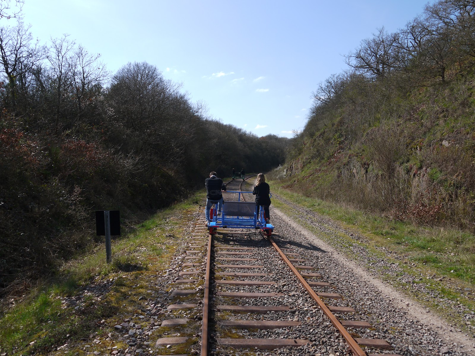
Maybe it was because we arrived at the very beginning of the opening season (in fact it may well have been the first day of operation), but we were only offered the 9km outing for our trip.  This would take us down the valley to the station of Pont de Brie (only a wayside halt), before we would be required to turn ourselves around and come back.
Orne River

As with the velorail in Perigord this one ran to a strict timetable to try and reduce the number of manoeuvres on and off the rails.  We were joined by a very lively and giggly group of youngsters who were rather surprisingly placed behind us in the queue.  In fact there was only one couple put in front of us.  That suited our two daughters just fine as they were in a hurry to get us parents pedalling them as fast as we could to the other end!
St Anne's Chapel

The route started through a very rocky cutting, with enough room for another track although only one was provided.  The space for the second track seemed to be a popular route for dog walkers and we passed several on the way to the next river crossing barely half a mile from the last one.  The engineers certainly provided some impressive viaducts to get across the Orne.  I guess the narrowness of the valley left them little choice.
Banking Around the Level Crossing

We paused on the viaduct to get a view of the river.  As we crossed a man and boy passed underneath in their inflatable boat.  I have to admit that looked another rather idyllic way of exploring the Orne.  On the south side almost underneath the viaduct is a small chapel, apparently called Saint Anne.  It seemed an odd place for a chapel, but legend has it that it was put there to mark the spot where a young boy was miraculously healed from wounds he sustained after an attack from a wild boar.
Derelict Mill

Across the other side of the river and the railway took a course down the shady side of the valley.  In the early spring afternoon, the temperature instantly dropped a few degrees without the benefit of the sun and we were quite glad of our coats!  The gradient of the railway seemed to be dropping as we headed south, which made for some nice quick pedalling.  I think the thing I really appreciate about these routes is the fact that they are ‘real’ railways in every sense, with all the infrastructure still in place unlike those that have been turned into walking trails.  From a velorail you also get a far better view of your surroundings than you ever would have done from a train!

Former Platelayer's Hut
We stopped briefly at a level crossing, guarded by a cottage built in the same style as pretty much every crossing cottage I have come across in France.  I hope the designer got royalties from every one that was produced!  The remaining part of the line took a course pretty close to the river and the air was full of the sound of rushing water and birdsong; the warmth seemingly bringing out all the bird life in the area.  High above us we could see circling buzzards, some of them impossibly high!

Nearing the End of the Ride
At a bend in the river further on we passed the ruins of the Moulins Du Pray.  I guess this was a water driven mill, but I have not been able to find much history of the old place, except to say that it ground corn and closed in 1952.  Sadly it was the wrong side of the river to explore further, but apart from the shell of the building there didn’t look to be much left.

Coming to a Halt
The rails were in quite bad shape on some sections of the line.  I guess any trains that would want to use the line would have to travel at a pretty slow speed in order to continue safely.  There are still some discussions about bringing tourist trains through here apparently, but the line would surely have to be relaid in order for it to happen?  Much of the other infrastructure looked in pretty bad shape, including a platelayer’s hut that seemed to consist of little more than the metal frame.

Riders
All too soon and we reached the station at Pont de Brie.  This looked like it was little more than a halt, with a low platform and not a lot else.  Or so I thought – at the far end of the platform I later discovered that the old station building still exists as an auberge.  The Google Street view picture shows rather an attractive looking place & I felt annoyed that I hadn’t taken the time to look further.  Maybe next time we come?  We all agreed that the 9km version of this route was lovely but rather less than satisfying as we all had the energy and enthusiasm to have explored a whole lot more.

Final Station
We turned our velorail by the rather unsophisticated method of picking up the whole vehicle and manually turning it.  No we found ourselves towards the back of the queue, which wasn’t so enjoyable especially as the youngsters in front had nothing like as much stamina as us and all struggled to pedal up the surprisingly steep line on the way back.

Orne Viaduct
This is a very enjoyable stretch of line, perhaps equalling the Pont Erambourg section in terms of scenery.  However, for history and railway features it was lacking the enjoyment of the other part of the line.  At 9km it was lacking some distance and perhaps next time we come we should try and ensure we get to look at the whole section available.

For more pictures from our trip please see My Flickr Site