Thursday, 19 May 2016

Westerham and Chartwell

Winston
Rather randomly my daughter had an inset day on a Tuesday and faced with a beautiful day and at the height of bluebell season we decided to head off and find ourselves a good wood.  I had a mind to go to Emmetts Garden in Kent as we had never previously visited.  That meant that the best walk for us to do in the area was number 5 in Pathfinder Guide volume 8 Kent Walks.  My wife and I actually bought the book when we lived in Kent and it was the first time it has been off the shelf in 15 years!

Westerham Pond
Westerham is indelibly linked with Winston Churchill although it was also home to General James Wolfe too.  Both men are commemorated with statues in the town, with Wolfe brandishing a sword while Churchill languidly sits on a bench in the middle of the green.  This was the official starting point for our walk having wandered the short distance from the long stay car park on the edge of town.

View Across to North Downs
We didn't stay long in the heart of town for our path took us down an alley opposite the green and before we new it we were out in the countryside beyond.  It was a sunny day with plenty of puffy clouds lumbering across the sky.  I did wonder whether they would eventually cover the sun entirely but they never did thankfully.  There was still a chill in the air - summer has definitely not quite arrived yet!  However it was that magical time of year when the leaves just start turning from buds into full blown foliage, the colour of the new growth is such a treat every year.  In the backs of the gardens of Westerham there were also a few blousy looking cherry trees sporting their pink and white blossom.  This is equally short lived and has to be appreciated while it lasts.
Bluebells
We walked along the side of a field at the back of Westerham houses and as we did we caught sight of a jay - it has been quite a while since I've seen one and for my daughter it was the first time ever.  She thought I was pulling her leg when I told her that it was a member of the crow family.  To be honest I can see why she was so incredulous - they do look like crows wearing fancy dress!

Laying Down
Soon we came upon a small lake that looked for all the world that it might once have been attached to a mill.  Now just a green oasis we enjoyed the antics of the ducks briefly before moving on past the rather attractive lodge house announcing the start of Squerryes Park.  The house at the centre of the park seemed to be out of sight, rather hidden by some trees.  The house itself is no longer open to the public so looks like we have missed our chance at least for the time being.

Tower Wood
The walk across the park was delightful, with views back towards the scarp slopes of the North Downs.  I think we might well be tempted to tackle that walk as a family in the not too distant future.  Long time readers of my blog will know that I started the walk in 2004 and walked all of the Surrey stretch before running out of steam at Otford almost in sight from this location.  The path was quite obviously heading uphill as we climbed the slopes of the Greensand ridge just to the south of the North Downs.  For my money the Greensand Way was a far superior path to the North Downs Way, probably because it is much quieter and not spoiled by the roar of traffic from the M25/ M20.

Fresh New Growth
Eventually we came to the woods and the bluebells didn't disappoint - thick blue carpets everywhere and we seemed to catch them at their zenith.  We stood and stared for a while enjoying the spread, feeling very lucky that we had the while place to ourselves.  As we headed onwards we passed a field full of cows all laying down - hopefully not a sign of things to come?

Picnic Area
Our path headed further and further into the woods.  We came upon a section that was cleared but otherwise it got denser and denser and we felt that we were firmly in fairy tale country.  In truth the woodland was so densely packed it made me feel slightly uncomfortable.  I was pleased then when we joined the Greensand Way proper for I knew that we would soon see views out from the ridge.  As we got to Mariners Wood we passed a rather strange and random little picnic area.  It looked like it had been left as unwanted furniture from the neighbouring property yet you could not describe it as fly-tipped as it was set out nicely.  I wonder how many passing walkers avail themselves of the facility?

Mariners Hill View
The view from Mariners Hill is quite special.  I paused for a time looking out over the Weald from here - the brooding clouds added a certain menace to the scene but here and there shafts of sunlight lit up small patches of countryside.  We dropped down from the top of the ridge to the estate of Chartwell below heading down through more exquisite bluebell lined paths as we did.  The next part of the walk was less appealing - we had to pass by Chartwell along a very busy road (the one bringing the shedloads of visitors in!)  Lucky for me that I had no sense of smell (courtesy of a cold) for my daughter reported that the aromas from the visitor cafe were very appealing!

Chartwell
Chartwell was of course the home of Winston Churchill and as a result is probably one of the most visited of any National Trust properties.  It is a great place to look around but we decided that it ought to be a family trip rather than just the two of us and so we continued on our way, turning left and off the road as we got to the end of the car park.  What followed was a very hemmed in path and one which was pretty muddy, an unusual section for this walk.  This continued all the way over to the hamlet of French Street.  I remembered this part of the Greensand Way for the lovely blooms on the rhododendrons and was pleased to see some were out as we reached the hamlet.

French Street
We dog legged around the scattering of houses and the rather unusual burial ground in the middle dominated by a very large yew tree (isn't there always a yew tree in such places?).  Our path almost seemed to double back on itself, albeit at a slightly higher level.  We descended into the forest again and the feeling of loneliness returned.  I think my senses were heightened by the fact that my daughter was with me.  Probably a good job that there are no dangerous wild animals in the UK for if there were this is exactly the sort of place I might find them!  It wasn't all unpleasant though - the siging birds were a joy to listen to.

Burial Yard
Eventually we emerged from the woods onto a main road at Hosey Hill and passed an old school.  I was slightly disorientated here but soon found the path on the opposite side of the road.  From here our way back to Westerham got a bit confusing.  Not quite sure how we did it but we found our way back to the lodge house that we had passed at the beginning of the walk even though we were supposed to meet our original path at the end of the alley into Westerham.  No matter - it added only a little bit to our journey and we managed to get back while still in sunshine.  Over the North Downs was the blackest cloud I have seen for some time - we managed to get back to the car without getting wet, quite a result!

Westerham
This short walk is a good one for bluebells (and other spring flowers for that matter) and could easily be used as an opportunity to explore Quebec House (home of General Wolfe) and Chartwell (home of Churchill).  I could imagine this walk could then be an all day affair.  As it was it took us a little over two hours - just about perfect before heading to Emmetts Garden nearby for a welcome tea.

Monday, 9 May 2016

Durford Heath and Rogate Common

Durford Heath
Our latest walk is another short one - walk 1 from the Pathfinder Guide volume 66 West Sussex and the South Downs (it is also walk 1 in volume 52 More Sussex Walks).  We are seeming to manage little and often again now the weather has warmed up - no bad thing perhaps but I am yearning for some more challenging walks.  We chose this one on the basis that it may well be mud free and I am pleased to say that it was mostly true :)

Avenue of Trees
The walk started in the pocket car park at Durford Heath, an area of the Weald in the very northwest corner of Sussex.  Long time readers may know that I parked here when walking this section of the Sussex Border Path (https://www.flickr.com/photos/worthingwanderer/sets/72157627948044489/).  On this occasion though I headed out in the opposite direction, walking down through the magnificent forest that characterises Durford Heath.  This was a very different Durford Heath than the one I visited all those years ago though for the trees were largely bare.  This meant that the woodland was a whole lot brighter and possibly as a result there were no deer on this occasion.

Bluebells
The path led largely downhill for quite a long time, weaving around the trees and avoiding the mud (yes there was some!).  Eventually we took an uphill route out of the trees and finally came out into the open.  The view across to the South Downs in the distance was quite magnificent and the big puffy white clouds really enhanced the scene ahead.  All alongside the path were clusters of primroses and bluebells; spring really was very much in full swing now.

Perfect Sky
As we left the wood our path changed character somewhat.  No longer the open path through the woods it started to become hemmed in by flowery banks and newly growing ferns at one stage it got deep enough to feel like we were just peeping over at the surrounding fields.  The views across this stretch of countryside were quite superb and for me this was perhaps my favourite part of the walk.

Field Views
Because of the shortness of the walk we had to keep our wits about us with directions and soon it was time to turn left along an even more sunken lane.  This was so deep we couldn't see out of it for a while!  This eventually came out into a road by a pumping station and we continued along the same direction passing some impossibly pretty looking cottages still flanked by daffodils despite the lateness of the season.  The gardens outside the properties looked well tended and it was no surprise to see gardeners hard at work.  I suspect that most weekends are taken up with keeping everything in check!

Hollow Path
At the final cottage before the road changed direction we turned left again and headed back up the hill towards the woods of Rogate Common.  We soon reached the house known as Commonside and it is hard to think of a more idyllic spot - the house is magnificent and the pond outside rather fascinating.  It was our last view of open countryside for the path disappeared into the woods again.  

Slade Farm
The woodland was notable for whitebells, a rather rare albino version of the bluebells that normally cover the forest floor.  The white ones are not quite as rare as some would have you believe but it is always a treat to see them.  I think the pink ones are even rarer - don't see too many of them.  We also caught sight of a buzzard though here - he was sitting on a tree for a while before flying off when he saw us.  That was quite a treat I can tell you!

Kingcups
The rest of the walk was largely though trees, mostly pine (unlike the deciduous trees of the forest at the beginning of the walk).  This is obviously an active forest for a big section had been clear cut, opening out a big area that will no doubt soon be colonised by new plants although it looked a bit bare at this time.  Considering that this was only a 3.5 mile walk we packed a surprising amount into the short distance.  It was truly the perfect day for walking too!

Sunday, 1 May 2016

Derwent Valley Heritage Way Section 6 Derby to Derwent Mouth


Shardlow Docks
After our abortive attempt to do this walk a few weeks earlier we were pretty pleased that another opportunity came along pretty quickly at the end of the Easter school holidays.  This would be a rather different section of the Derwnt than we had been used to thus far as the hills were now long behind us and the terrain was pretty flat for the whole route.  We parked in the village of Shardlow about as close as we could get to the end of the hike and got the bus to Derby Station to resume the walk.

Former Railway Building
It was a bright sunny day to begin with although being a spring day it always looked like it might change later in the day.  For now though we enjoyed the warmth as we retraced our steps along the road that we had had to run along a few short weeks earlier.  The station at Derby still gives a hint of the mighty railway centre that it once was.  It is perhaps the only city in Britain that still builds trains and a few underground ones destined for London were lined up just near the station.  Most of the other buildings are now mostly used for something else but there is no doubting their original heritage.  The houses opposite are also clearly railway cottages and what a fine sight they make now they have been gentrified.  I don't suppose they ever looked as smart!

Railway Cottages
We reunited with the river and headed eastwards under the concrete bridges of the ring roads; a far cry from the beautiful Peak District section.  In fact the next mile or so of the walk were fairly charmless as we wandered along a stretch of river now seeing some massive changes on either side as the former railway yards and depots are now transforming into a more 21st Century landscape of retail parks, business parks and rather uninspiring looking housing.  Perhaps the latter will look better when they have blended in a bit but I always think that new houses are a bit stark.

Pride Park
The river wound around the biggest edifice of all - the large expanse of Pride Park, home of Derby County FC.  They were at home today against one of the other 12 founding members of the Football League, Bolton Wanderers.  Fans were starting to gravitate towards the ground although it was pretty early for kick off, which wouldn't be for a couple more hours.  We wandered by and soon we lost the rather temporary looking landscape of regenerated Derby and entered a rather pleasing park after passing underneath yet another railway line.

Railway Crossing
The mood of the walk changed almost instantly.  We were now in Alvaston Park and this was a well tended landscape full of daffodils and a few hopeful fishermen sitting around the pond at the heart of it.  As we headed further east the Saturday football matches were in full swing and the intensity of one of them suggested that it was one of some importance.  At the far end of the park we passed by a BMX track but sadly this seemed to be out of use for the day.  I would have quite enjoyed watching the youngsters performing their tricks as we went by.

Alvaston Park
The river was a constant companion and it was getting ever wider and man-managed with weirs and other devices designed to tame it and stop it being such a flooding threat to the settlements around.  Almost imperceptibly we were leaving the city behind although looking at the map that didn't seem obvious as there seemed to be plenty of settlement around.  Strangely the built up area seemed to diverge away from the river - perhaps the flooding just got out of hand when the nearby areas of Alvaston and Borrowash were developed?

Alvaston Park
The last of the big weirs was just before Borrowash Bridge and was quite fascinating to watch.  An enormous amount of energy accompanied the river as it tumbled over the man made weir.  It was around here that we really felt that the countryside properly started.  Just beyond was Borrowash Bridge, a single lane affair that had to be signal controlled.  This made life rather easier for us in terms of crossing the road, which was welcome as it had the hallmarks of being quite busy.

BMX Track
The field opposite was enormous and I am guessing was normally full of sheep.  I base this not on any evidence of sheep but bizarrely because of a large number of swedes that lined the path alongside the river.  It was a very strange sight and in fact we didn't think that the swedes looked very appetising for any creature, including sheep.  The farmer had dumped hundreds around the field and I suspect that they will end up acting as compost rather than fodder.

Weir
About a mile from Borrowash Bridge and shortly after passing some new duck families (broods that were quite big!) we left the river as sadly there is no path along the bank from here to the mouth.  It was also about here that we lost the sun as the cloud that had threatened for much of the day finally closed off the blue sky.  In fact the showers away in the distance looked pretty meaty and we were hopeful of avoiding one as a severe wetting looked to be a distinct possibility.  Our most immediate problem though was negotiating some pretty muddy fields (although nothing compared to last week in Burwash).  We were pleased to find ourselves in the lonely feeling Ambaston Village for no other reason than having some solid ground under our feet.  The village itself was rather strange - I couldn't quite work out who had decided to start it as there was no church, pub, shop or any other focal point.  It is remote enough that you couldn't even call it a suburb.  It was mostly silent as we walked through apart from a couple of bods washing their cars.  Not a place to linger long that is for sure...
Borrowash Bridge
The onward walk to Shardlow can be described as nothing short of completely uninspiring as we trudged along a road for a mile and a half with increasingly grey skies.  It wasn't very pleasant and seemed a rather sad end to what has otherwise been such a lovely walk.  When we got to Shardlow the children had had enough and we saw a huge shower coming our way and this prompted us to call time on the day here.
Turnips

There was still the small matter of walking to the end of the trail and so we decided to go back early next day when the weather was an awful lot better.  It turned out to be a good call.  Sunday morning was everything that Saturday afternoon had not been.  The showers had gone and the clouds blown away to reveal a beautiful crisp start to the day.  The walk along the Trent and Mersey Canal to meet the mouth of the Derwent was nothing but a pleasure.  It was a little strange walking along a towpath again with the river nowhere in sight but it did remind us how much we like canal walking.  Thoughts turned to the next walking project now that this one has been completed.  We all agreed that it would probably be somewhere closer to home so that we didn't need to find free weekends but just the odd day.

Road Walking
The end when it came was something of an anti-climax.  Our guide book suggested that there was a largish concrete footbridge across the canal where it met the Derwent and the River Trent.  When we got there though the footbridge was gone, replaced we were guessing by a new metal one some distance further along the river.  Apparently the concrete one was demolished in 2003 - just showed how old our guide book was!  Anyhow - we felt a sense of achievement finishing this walk and were thankful of such great weather at the end vindicating our decision to save this bit from the previous day.
Derwent Mouth
The Derwent Valley Heritage Way was certainly a fascinating journey.  Even the last day although probably the least scenic section still had its moments and the last mile in particular was quite charming.  Now onward to a new walking project with the girls!

Monday, 25 April 2016

Burwash and Bateman's

Burwash
The village of Burwash is perhaps one of the most scenic in all of East Sussex and it was inevitable that one of the walks from the Pathfinder Guide "East Sussex and the South Downs" (volume 67 walk 8).  It also appears in volume 24 "Surrey and Sussex" (walk 8).  After a pretty long dry spell of weather we felt safe doing this walk despite a warning of muddy conditions.  It was a dry and slightly chill spring day with no clouds but a slight haze in the air and it was a pleasure being out in a different part of Sussex than we are normally used to visiting.

Reminder
We parked in the village car park in Burwash, which was rather quiet for such a nice day.  I guess the next door pub wasn't open yet so perhaps we got here before the rush?  We started our walk along the High Street, an inviting looking place with clapboard and tile hung houses and shops lining the main road.  The village sign showing a forge reminded us of the iron heritage of this part of Sussex.  We didn't linger on the High Street for long as our path took us down a side street and past the very attractive looking Rose and Crown pub.  The earlier volume talks about a fire station down here too but that is long gone.

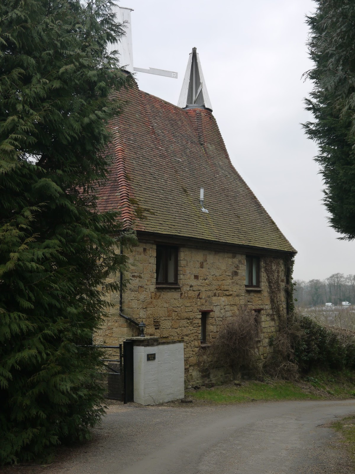
Oast House
Soon the lane gave way to a track that weaved its way through fields with some purpose.  On our left hand side some views of the Weald opened up and the fields had some sheep and lambs although they were rather a long way off.  Soon we were to leave the comfort of this track and head off across the fields and into a wood where we encountered our first mud.  It didn't bode well for later on the walk but for now it was relatively easy to pick our way through.  We headed for a stream and upon meeting it followed it for a short while and then crossed via a small wooden footbridge.  As we climbed away from the stream we headed up towards a largish oast house.  This has become the most fabulous looking house - must be fantastic to live somewhere with so much character!

Dead Orchard?
The oast house was actually part of a small hamlet when we got closer and each one of the houses looked splendid.  The gardens were well tended and resplendent with their daffodils on show.  Just as it looked like we would cross the garden of one of the houses the path took a detour out through what almost be described as a tradesman's entrance!  We entered what at first looked like a dead orchard but on closer inspection we decided that it was alive.  The trees didn't look in great shape though - perhaps they needed some extra tlc to get them going once again?

Franchise Manor Drive
At the other end of the orchard we entered rather a grand looking track that was tree and daffodil lined.  Almost immediately we also came upon the war grave of Reginald Rimmer, a young pilot who was shot down here by a German during the Battle of Britain and crashed here.  He was just 21 years old.  A brief history and his picture can be found at here.  It was rather sobering stuff and a reminder of how widespread the fighting was during the desperate struggle of 1940.  I certainly never realised that dogfights took place over the Sussex countryside as well as in Kent.

Reginald Rimmer Memorial
We walked up the driveway I am guessing away from the place it leads to for eventually we found ourselves at a white gatehouse (which didn't look too shabby itself!).  I later learned that the house the drive led to was called Franchise Manor, but it was out of sight for us.  The dalliance with the road didn't last long as we were soon on Holton Lane, one that looked rather like it could have become part of the highway network but which the authorities never quite got around to surfacing.  The going became sticky for a while and there were patches that were pretty difficult.  Just as we thought we had got through the worst of it we realised how mistaken we were for the mud became impassable about three quarters of the way along.  We managed to scramble our way through using some fairly tenuous looking routes clinging on to banks, tree trunks and even barbed wire fences as we did so.  Beware a winter walk here - it won't be fun!

Woods Along Holden Lane
Eventually we got through the worst of it and crossed a main road.  The last half mile had taken nearly half an hour to walk and had sapped our energy considerably.  The road was a welcome relief in terms of surface but it is also very busy and a great deal of care had to be exercised in walking the sort length to the onward path.  We managed to escape from its clutches feeling very relieved as there is virtually no room to be here.  

Cyclamen
On the other side of the road we followed another drive down to another oast house.  This time we didn't just have daffodils lining the route but cyclamen too - rather an unusual sight for the countryside but a welcome burst of colour nonetheless.  Upon reaching the house we crossed into a horses field which was churned up but mostly dry at least.  From here the route took a very pleasant course across fields and through a few small tracts of woodland down to the back of the Bateman's estate.  Along the way we got views of the church in Burwash - a landmark for some miles around by the look of things.  Our first glimpse of Bateman's came at the start of the millstream that fed the estate watermill and which still functions.

Burwash View
Bateman's is famous as being the home of Rudyard Kipling, author of the Jungle Book and one of the most popular writers of his generation.  He certainly was not a penniless writer as the large house demonstrates.  We had intended visiting as part of this walk but in our current state this was out of the question as two of our party had sodden feet and we were all covered in mud.  I don't think the National Trust would have particularly welcomed our visit!  We contended ourselves with a brief look at the water mill and a view of the house from the outside before heading on to finish our walk in Burwash.  We had visited the house a couple of years previously and it was certainly worth a trip then - maybe we will come again soon?


Bateman's Watermill
The onward walk from Bateman's was largely uphill.  The house is not visible from the village despite its proximity.  I imagine this was part of Mr Kipling's thoughts when he was here.  The walk was pleasant but a little bit of a sting in the tail at the end.  At five miles total length though you shouldn't feel too tired at this point, although we did feel like we had walked a lot further courtesy of the muddy conditions!  If you try this walk - do yourself a favour and come in the summer or autumn...

Bateman's

Monday, 18 April 2016

Sussex Border Path Section 19 Ashurst and Bolebroke Castle

Sussex House Farm
This ended up being another day where sunshine was promised that never materialised.  That was a great shame because it put a bit of a dampener on the walk that in hindsight was a bit unfair on the scenic quality of the landscape.  It had been almost 18 months since I last visited this walk and it has to be said that trips out by myself are becoming fairly rare commodities.  Encouraging the family to accompany me on a partially completed project isn't very fair and not a particularly attractive proposition for them.
Ploughed
I pitched up in Cowden and parked once again by the church.  Despite the length of time away it didn't seem like it had been anything like that long.  The church is one of the most attractive I have seen in this part of the country and certainly has an unusual design.  The village was pretty much deserted and I imagine it is something of a dormitory village as it has a railway station on the line to London, albeit some distance from the village.
Dead Machinery
I retraced my steps through the nearby allotment site, which was rather empty looking save for a few rather tired looking cabbages and a couple of pensioners digging over their plot.  They were the last people I saw for some considerable time.  When I entered the golf course that I had had such trouble with before I turned left instead of right and that enabled me to enter an adjacent field and leave the golfers in peace.  The path headed due east through a number of fields and following a stream that formed the boundary between East Sussex and Kent.

Dead Machinery
The path bounced between the two counties for a while along paths that were surprisingly dry considering how much rain we have had over the winter.  It was pleasant if slightly uninspiring countryside and not helped by the stubborn overcast conditions, which did not seem likely to change however optimistic the forecast was.  The highlight though was the sounds in the air - the birdsong definitely suggested that spring was well and truly underway.

Under The Railway

When I came to a main road I cross back into East Sussex by crossing the stream bridge and passed through a horse field that looked very cut up and rather unwelcoming for the various horses that lived there.  No wonder they tried to make friends with me as I passed through - I would have done too if I had had that type of dining available.  They probably wanted to find something else more tasty to eat!
Ashurst Viaduct
I proceeded along the stream valley which seemed strangely quiet and for the south east of England at least rather remote feeling.  I did spot a couple of oast houses along the way reminding me of my proximity to Kent and passed by a golf course rather unsurprisingly.  The number of golf courses in this area is pretty surprising - I'm not sure how they all manage to get enough custom?
Wonky Chimney
I eventually found my path blocked by a railway line and briefly had to follow it before I was able to cross via an underbridge.  This line would once have taken me back to my home town of Lewes but is now truncated at Uckfield.  The frequency of trains has been affected recently as usage of the line has increased enormously and the stations along the way are having their platforms lengthened as a result.  It has also meant that there are no trains during the day on weekdays until the work is completed.  It gave the air of an unused railway as I followed the line for a while.
Primrose Banks
I left the stream I had been following for a while after another half mile or so.  My path across a field was not a particularly pleasant experience through the softness of the turf.  I eventually reached a farm full of old machinery and a small unit that made ice cream.  I've always wondered about the assorted scrap machinery at farms - there must be enough about to provide raw material for a steel works for several weeks if it were all sold for scrap?
Primroses
I wandered through the farm and turned to head across another field adjacent to the railway.  I was now in the main valley of the River Medway and the river was surprisingly large here considering how far from the sea I was.  As the area between the river and railway narrowed I wondered where I needed to go next and soon discovered that there was a narrow walkway underneath a metal viaduct that enabled me to continue following the river but cross the railway.  The path on the western side of the railway didn't last long for I was soon to meet a main road whereupon I turned left and across river and under railway once again!
Lyewood Common
This was the village of Ashurst, a familiar name for a settlement in these parts (I know of at least two others locally).  There wasn't much of a village to explore but on walking past the railway station I saw the magnitude of the task that the contractors extending the stations had.  There were piles of materials and loud machinery disturbing the peace as the work progressed on making the platforms bigger.  It was heartening to see this largely rural line getting such a makeover.  I hope that would-be passengers haven't been put off by the lack of service while the work continues.

Oast at Perry Hill
I was soon past the station and the peace soon returned.  The path followed the railway for a short time although at arms length.  One house on the edge of the village caught my eye because of its very wonky looking chimney.  Just past here and the path did a sudden turn to the left and headed up the hill along a lane that was flanked by primrose banks on either side.  They brought some much needed colour to a very grey day.  At the top of the hill I turned left and headed down through some rather lovely woodland.  I imagine that on a summer's evening with all the leaves on the trees this would be a delight as even today I derived much enjoyment from this short section.
Bolebroke Lake

All too soon I reached a junction at which I would leave the Sussex Border Path to take my route back to the start.  I had devised a route that would take me back via Bolebroke Castle - not officially on the Sussex Border Path but one that was probably too good to miss.  Sadly the route was rather uninspiring not helped by very bare trees, large numbers of bare fields, little in the way of bird song, muddy paths and a day that was getting increasingly gloomy.  I chalked off the miles with little joy it has to be said.  The only highlights were a very green looking pond at Lyewood Common and the odd oast house along the way.  I walked along a road for some distance and then cut down through Perryhill Farm.  There were some very nice looking houses in the vicinity it has to be said and no doubt command some very high prices when they get sold.

Bolebroke Castle
I crossed the main road shortly after and was thankful for a farm shop on the other side when I could get some refreshments.  This was at the entrance to the road up to Bolebroke Castle.  I wandered up the drive and as I did so I caught sight of some rails in the woodland but they didn't look too healthy.  I remembered then that there was a miniature railway that operated around the grounds of the castle some years ago.  Clearly it wasn't functioning any more and I later learned that it closed upon the death of the owner in 2012.  A sad end to what had looked like a nice little operation.
First Bluebell of the Season

Bolebroke Castle looks to have changed hands too - it was once a hotel that catered for haunted weekends.  Guests would allegedly get the opportunity to look for the ghost of Anne Boleyn who is said to roam the corridors of this former royal hunting lodge of King Henry VIII.  The reviews of the hotel make for pretty grim reading though and so the new owner has perhaps decided not to keep it going but just use it as a residence.  The price was £1.6m - a pretty hefty price tag but there looks to be a lot more investment than that going into the place judging by the works going on.

Golf Course
The onward path disappeared into the woods that were probably home to the quarry being chased by the royal party nearly 500 years ago.  For me this was the most enjoyable part of the day's walking as the woodland was most attractive and the going pretty easy.  There were signs of bluebells already coming up and a few hardy plants were already flowering - I was rather surprised to see bluebells this early in the season.

Cowden Church
As I emerged from the woods the path was rather less pleasant due to the boggy conditions and in places it was treacherous.  I was pleased to reach a main road, which I crossed and headed round a field and through some woods to emerge onto the golf course to the south of Cowden once again.  It was a relief to finish this walk - ground and weather conditions did not make this the most enjoyable of days sadly.  My faith in the weather forecast today was also misplaced - if the conditions had been better I think I would have enjoyed my outing far more.