Sunday, 30 April 2017

Wey Navigation Godalming to Guildford

Godalming Church
Walks this year seem to be more sporadic as the time available seems to be ever more at a premium.  This particular Saturday walk was a welcome one especially as it coincided with one of the first good weather days of the spring.  We had actually completed this walk a year before but dunderhead that I am I managed to delete all the pictures from my camera.  We discovered that not only was the weather remarkably similar to that day, but it was also the corresponding day in the calendar - how spooky!

Park and Bandstand
This is far from a challenging walk - it is only just over four miles long and largely flat as it heads along this branch canal.  Some of the walk was completed during the wander along the Wey-South Path some years ago.  This section is still used and may provide the link from the Wey and Arun to the River Thames in years to come.

End of the Navigation
We started at Godalming; the very end of the canal section.  Godalming is a pleasant place, clearly with some wealth behind it.  In that respect it isn't a lot different to many other towns in Surrey.  We parked at the station, which was fairly inexpensive on a weekend day (beware bank holidays - they are inexplicably more expensive).  The rail service between Guildford and Godalming is roughly half hourly so getting back isn't too much of a problem. 

Boat Hire
From the station it is best to aim for the very large church as the river is almost right next door.  We passed by the Phillips Memorial Cloister.  This curious feature commemorates the life and death of the chief wireless operator on the RMS Titanic, Jack Phillips who was responsible for sending out the distress calls from the ship on that fateful night.  The gardens inside were designed by Gertrude Jekyll, famed designer of the early 20th Century.

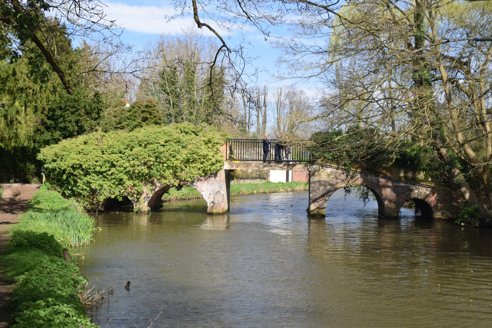
Trowers Footbridge
We stopped for a bit of lunch in the park and watched with amusement as the ducks, geese and swans were all engaged in various courtship rituals.  There was no boat traffic here as the river is not navigable past the Town Bridge.  That seemed to help the birds as they were largely undisturbed.  The park was properly waking up from its winter slumber.  Flowers were brightening up the whole scene and the weeping willows overhanging the river were bedecked in their early spring foliage.  Coupled with the powder blue sky the whole scene looked very fresh and young.

Blossom
Just beyond the park and we emerged onto the main road through the town which was a bit of a shock to the system after the tranquil surroundings that we had come from.  Thankfully it was short lived as we resumed our course along the River Wey on the other side.  Just around the corner and we reached the town basin at end of the navigable section of river.  There were quite a few boats moored along this stretch of river, most of which looked like they were still on their winter break.  In fact we all noted how little activity there was on the river - to be fair the temperatures were still a bit chill.  I suppose it needs to warm up a bit more before people properly get going.

Pillbox
After a lengthy straight stretch of river we came to our first lock at Catteshall.  We coincidentally found a boat coming through it - the only activity we saw for several miles.  The lock had a boathouse just the other side although there was little sign of anyone wanted to hire one of the boats on offer.  The river took a meandering route from here winding through small trees just showing signs of sprouting foliage.  We went under the unusual Trowers Footbridge, which was apparently built to access the nearby Unstead Park.  It was a rather grander affair than would be provided now but probably befits the importance of its destination.

Exclusive Parking Spot
The route was characterised by a number of pillboxes along its length and the first of these was shortly after.  These ones are unusual in that they are perfectly round, unlike the square ones that we see in Sussex.  The River Wey was clearly felt to be an important strategic route for any invaders as they are still pretty prominent even after all these years.  After a meandering route we lost the river over a weir and the navigation became a proper canal, complete with lengthy straight section.  We passed by the picturesque Unstead Lock.  Just off to the left was a picturesque garden with what looked like a berthing basin for boats - indeed there was one in position as we passed by.

Half Pint
Two former railways crossed the canal just north of here - the first is now occupied by the Downs Link footpath that links Guildford with Shoreham using the trackbed of the former lines that crossed Surrey and West Sussex via Horsham.  The bridge across the canal has been replaced with a more modern span that is cycle friendly - I imagine that the original one was removed some time after closeure in the mid 1960s.  Further on is a slightly more dubious railway - certainly the earthworks are all in place but whether it ever carried trains seems to have been lost in history.  Certainly it must have been an early closure for the middle of the trackbed now sports a World War II pillbox.

Mighty Bridges
In between the two erstwhile railways is the stub of the Wey and Arun Canal, walked a few years ago on the Wey South Path.  There is a move to restore this and significant progress has been made in the past few years.  It will probably be longer than my lifetime to see this little stub of the canal becoming part of the through route though.  We also had to cross the busy A248 road - not an easy task.  I rather wished that the towpath went uder the road bridge but alas there is insufficent room.

Guildford Castle
The onward walk from here is very familiar as I have done it a number of times in combination with other routes.  For my money the approach to Guildford is up there with some of the most scenic canal walks in all of England, certainly the ones I have visited.  It starts at the rail bridge taking the North Downs railway across the canal and passes by the shallow lock of St Catherine's (it only brings the water up a couple of feet).  After meandering through some woods and passing the base of sandy cliffs Guildford comes into view overseen by its castle.

Negotiating the Locks
As we approached the edge of the built up area the canal boat that we had helped through the lock finally caught us up - it would only be ahead of us for a short period of time though as the lock in town soon held it up again.  By now we had also caught up with the hoards of people all enjoying one of the first genuinely warm days of spring.  Sadly my lot weren't particularly interested in a trip to Guildford Castle so I had to go with the flow.  I think perhaps it was the hill up to the top that put them off - maybe next time I come this way I shall make sure of a trip to the top.  For now though we made our way through the town to the station and returned by train to Godalming.  On the way we passed by a memorial to Lewis Carroll, who died in Guildford in 1898.  Rather fittingly it was of Alice watching the white hare running away alongside the canal.  I think this must be a recent installation as I don't remember seeing it before.

Last Crossing
As short walks go this is a particularly good one with plenty to see along the way.  I think perhaps we might try and complete this walk going north although it doesn't look as if transport links will be easy - maybe some out and back walks would work?

Lewis Carroll Monument

Sunday, 5 March 2017

Duddleswell and Nutley Mill

Ashdown Forest
Half term brought some beautiful weather with hints of spring in the air and we were all eager to get out.  We needed somewhere that was fairly dry underfoot and settled on Ashdown Forest.  This part of Sussex has always been a bit of an enigma for me - I've travelled through dozens of times over the years but walks are still quite rare.  In fact I realised when seeing a picture of Nutley windmill that I'd never seen it up close and felt that I had to fix that.  I delved into a different guidebook for this walk, Cicerone Guide Walking in Sussex - this is walk 11.

Lunch Stop
We parked opposite Duddleswell tea rooms.  I remember this place being impossibly busy back when I last visited more years ago than I remember.  Today though it was empty and closed - probably a lot less clientele around on a winter's midweek day in February.  As soon as we got going we had some difficulty with route finding.  That isn't unusual to be honest and probably why I haven't been up here too often.  There are so many paths that it isn't easy to know whether you are on the right one...

Nutley Clock
We got in a bit of a tizz trying to find our way through the bracken but in the end the view of Nutley in the distance and the lie of the land got us there.  I was rather surprised at how many houses had been built on the edge of the ridge and even a new build was going in.  That was perhaps the biggest surprise of all but sure it must just be replacing an existing house?

Nutley Church
We dropped down a broad ride through the forest to a confluence of streams at the bottom of the valley.  Even though we had barely covered a mile the children were already angling after their picnic and this seemed as good a place as any to stop.  Picnicking in February is not quite the same as it is in June but this little place did make for a lovely place to stop.  

Pink House
After refreshments we continued on our undulating route towards Nutley.  We could see the  grave of some airmen who crashed here during wartime.  Our route this time did not pass close enough to look more closely - we'll come back another time I think.  We routed around a farm that looked as if it were geared up for equine farming rather than anything foodwise.  There was a lot of activity in this area, mostly men and Range Rovers.  Not sure what this was about but was thankful that it did not seem to involve shotguns this time.

Old Lodge
Once past the farm we dipped down into another valley before climbing up through the woods and into the village of Nutley.  I've always though that this otherwise attractive village is rather spoiled by the A22 running through the middle of it.  Villages with main roads running though the middle of them seem to lose a lot of their charm and this one is no different.  It was lovely to see gardens getting some colour back though - snowdrops and crocuses were on show in many of them - the bleakness of early January seems a long time ago already.

Nutley Mill
We passed by the small church and the school before diving down a lane to take us away from the village.  This was a very pretty lane and made for easy walking for about a mile.  The houses scattered along the lane had beautiful gardens and great views; they must be idyllic places to live especially as the road noise had already died away.  At the end of the lane the path climbed up through a small stretch of woodland and came out at a pink cottage.  We again lost our way a little here as the instructions didn't seem to match what was on the ground.  Luckily there was a path a little further along the road that we took although that meant we had to double back to the windmill.

Camp Hill
Nutley Windmill is claimed to be the oldest working windmill in Sussex and was built around 1700.  Sadly it wasn't possible to have a particularly close look as it is understandably locked behind gates when not open to the public.  The sails were also pointed away from us so I had to make do with the view that I got.  The sun helped though, coming out briefly from behind the clouds to shine on it and really light it up.  I dwelt here for a short time before rejoining the girls who had already moved on.

Surveillance
Our route now descended across typical Ashdown Forest country - bracken and small areas of woodland criss-crossed by broad rides/ fire breaks.  At the bottom of the valley the path became more intimate as we crossed over a stream and we followed it for a short time skirting around a rather grand building called Old Lodge.  Children were starting to lag by this point and so sweets had to come out to help them along :)  We also caught sight of a goldcrest in the hedge but try as I might I could not get a decent shot of it as it did not sit still for more than a second!  It was lovely to see Britain's smallest bird though - I don't remember a time when I have seen one this close before.

Camp Hill View
We found our way onto the drive to Old Lodge and followed it all the way up to the main road.  The sun was fully out now and we had an extended sunny interval as meteorologists would call it.  The trees that we walked through seemed to have an extra glow about them, especially the silver birches that positively gleamed!  The end of the driveway marked the start of the best bit of the whole walk.  We now headed alongside the main road and over Camp Hill, an iron age hill fort.  While the fort itself is not particularly impressive the views out from here most certainly are.  We could see right down into Hampshire from here and a squint through the binoculars enabled us to see Blackcap, Devils Dyke and Chanctonbury Ring.  By following the ridge of the South Downs west Bignor Hill could be seen and beyond until even through the binoculars I couldn't determine exactly what I was seeing.

Camp Hill
Just after Camp Hill we lost the sun for a short while.  The amazing thing about the sun going in at this time of year is that it transforms the landscape into a much duller version of itself almost immediately. Sadly this was the case as we passed by Ellson's Pond - we didn't pause to admire it like the people in the guide book did.  The sun did come back a little way further on though and immediately the temperature increased too!  By now we were almost back to the starting point and the onward track that we had missed at the start of the walk was rather more obvious.  Perhaps there is a case for starting the walk at Ellson's Pond to make route finding a bit easier?

Ellson's Pond

This eventually became a very satisfying walk but the route finding did prove to be a problem a number of times on the way round.  Mud was in short supply thank goodness, meaning that this is a pretty good winter option.  Ideally though try to pick a day when the tea room and the mill are open for maximum enjoyment :) 

Duddleswell Tea Room

Sunday, 26 February 2017

Blackcap and Stanmer Down From Ditchling Beacon

Sunrise
Early morning walks at any time of year are special but none more so than on cold and frosty winter mornings.  With the memory of my walk around Arundel Park fresh in the mind I was eager to have another early morning outing and made sure I got up while it was still dark so that I could be up on the hills when the sun came up.  After the mud and the less than perfect conditions last week this week could not be more different.  Conditions were benign but seriously cold when I got going and I chose a downland walk on the basis that the underfoot conditions would probably be better.  Thus I plumped for walk number 23 from vol 52 Pathfinder Guide More Sussex Walks.

Daybreak at Ditchling Beacon
Familiarity was the key to this walk for this part of the Downs is really where I feel at home.  Ditchling Beacon is not too far from Lewes where I grew up and this is the part of the Downs that I explored as a youngster.  I venture to these parts all too rarely these days but I always get waves of nostalgia when I do.  Parking at Ditchling Beacon is no joke these days although I was never going to have a problem coming at this time of day on a Saturday.  If you come later in the day on the weekend you might consider coming up here on the bus - a regular service comes up here from the centre of Brighton.

Grazing
I felt the chill wind as soon as I got out of my warm car and I soon realised that I wasn't alone for there were a couple of photographers around clearly hoping for a special sunrise.  We were a little early for that and I was pleased for the first half mile or so the skyline from where I assumed the sun would come was obscured.  I hurried along the chalky track to get to where I thought I might get a good view and was rather disappointed to see that the sun had beat me too it.  Nevertheless the red ball had only just cleared the horizon over towards Firle Beacon and it still looked very special indeed.

Which Way?
Surprisingly considering that I was on the crest of the Downs the best views were to be had to the south and east.  Even with the proximity of Lewes I didn't catch sight of it for some time but in the distance I could see the faint plume of smoke coming from the incinerator in Lewes.  Elsewhere on the Downs livestock continued their interminable grazing - must be awful spending all your life grazing.  I suspect that this went on pretty much all night too.  It wasn't just sheep up here either - a large herd of bullocks did their best to keep out of my way.  Further on was a different kind of beast - a large excavator that looked rather melancholy.  I suspect the farmer has been doing some work to improve the tracks up here - there was some evidence that work had started although I wasn't sure how extensive it would be for not much had yet happened.

Blackcap
Having enjoyed the early sunrise I could now see that the rays were extending beyond the ridge of the Downs to illuminate the countryside below.  I've always thought that being on the crest of the Downs is a bit like in a low flying plane - the view from the top almost has to be seen to be believed.  Far below me here is Westmeston and its dainty little church.  A little further on and I passed teh extensive grounds of Plumpton Agricultural College and then Plumpton Place.  The latter was where my mother grew up and subsequently became a haunt of Led Zeppelin as Jimmy Page owned it at the height of their fame.

Blackcap View
Plumpton Plain is a section of the walk that I could hurry along because it is essentially flat.  As I walked along I tried to imagine my grandfather working in the fields up here in the 1950s as he was a farm labourer at a nearby farm.  It really is that special to me around here.  Past Redhouse wood the main South Downs Way heads southwards but I continued straight on.  The path in the book skirts around the summit of Blackcap but I decided to head to the top so I could enjoy the view north across the Chailey and Shelley's Folly.  The trees on Blackcap are iconic for me although they seem a bit thinner than I remember.  It was replanted in 1953 to commemorate the coronation of the Queen.  It is remarkable that she is still on the throne!

Blackcap From Mount Harry
I lingered for a short while before continuing on to Mount Harry where I came across a brazier that I don't remember at all.  Turns out that this had a Queen Elizabeth connection too, only this time it was put here to celebrate her Golden Jubilee in 2002.  This is the territory that the Battle of Lewes reached and I tried to imagine the two armies at full tilt all those hundreds of years ago.  Although not widely known outside the area where I grew up, it was one of those pivotal battles in English history and led directly to the setting up of Parliament when Henry III was defeated by the rebel barons.  

Brazier
At Mount Harry I dropped down to another historic relic - the old Lewes racecourse.  Sadly horses haven't raced here since 1964, more than 50 years ago.  Yet I remember plenty of race horses galloping around the course when I was a boy, for the track still exists as a training course.  It is probably too much to ask that it will ever re-open after all these years, but I guess it theoretically is possible since all the infrastructure is still here.

Ouse Valley View
I turned here to head back towards Ditchling Beacon.  My return route was a lot less straightforward as I would be using paths that negotiated the dip slopes of the Downs and crossed a couple of the dry valleys that characterise this part of the Downs.  This part of the Downs is less visited for me but notwithstanding the ups and downs of the walking this area should perhaps get more attention.  I enjoyed it for there were no people about at all - a far cry from the runners and dog walkers on the South Downs Way.  I had some curious sheep for company and the warming sun - in fact the temperature had risen quite a lot and the frost had melted.

Creeping Halls
I found my way to the back of Falmer village before turning once again at what was marked as a farm on the map but what was in reality a pile of rubble and some rubbish that suggested that farming activity had ceased a long time ago.  I headed north at this point, following a shady tree lined road into the wonderfully named Shambledean Bottom.  As I did so my eye was caught by the sight of a large number of halls of residence that have found their way into the rural idyll of the Downs.  Of course these belong to the nearby Sussex University.  I found it rather astonishing how many have been built - there is seemingly no end to the expansion of our student populations.  I suppose the halls are really necessary to the whole operation.

Confused Cow
I passed by St Mary's Farm - a human habitation that is almost the antithesis of the halls.  Yet even here was plenty of activity.  I suspect that the farm does a sideline in shooting activities for a group had assembled for what looked suspiciously like a lesson.  I didn't hang around - the thought of a buch of shotguns being fired and shattering the peace of the morning was too much for me.  What lay ahead now was a lengthy climb back to Ditchling Beacon.  Fortunately it wasn't too steep but the climb did seem to go on forever - in all it was probably a couple of miles.  As I got back up towards the summit the numbers of walkers around increased considerably.  I felt a bit smug as I returned to the car to find that people were setting out for the day knowing that I had already experienced the best of it!  The car park was rather busier now and almost as soon as I left my parking spot it was filled by the next visitor.


Back to the Beacon
This is a great walk for a workout.  It has some fabulous views out across the surrounding countryside, among the best anywhere in the South Downs.  It is a little short on specific landmarks on the way round but I felt so good after it - just a little frustrated that my diary is so full looking that it looks unlikely that I will be able to repeat the experience any time soon.

Sunday, 19 February 2017

The Temple of the Winds From Fernhurst

Fernhurst
Regular readers of these walks will know that one of my favourite spots in Sussex is Black Down, the highest point.  For me this is a corner of Sussex that has always seemed a bit of an enigma - so very different from the South Downs that I grew up with, but no less appealing.  After a few days of wintry weather that my children were very excited about I thought it might be the one place nearby that managed to hang on to the white stuff.  With a friendly looking weather forecast it looked like a good day for a winter walk.  This one is walk no. 17 in Pathfinder Guide volume 52 More Sussex Walks and walk no.19 in vol.66 West Sussex and the South Downs.

Upper Sopers
The day certainly started out pretty well - the cloud looked like it was going to give way to sunshine as promised as we started our walk at the village green in the small village of Fernhurst.  I have to say that if I had been with my wife and not the two girls I might well have been tempted just to stay in the pub as it looked so inviting overlooking the green.  As it was the girls were keen to get up high as soon as possible to make their acquaintance with the snow.  The path climbed slowly out of the village and as we reached the edge of the housing we got our first view of the brooding mass of Black Down.  I have to say that it didn't look too promising from this angle and with warming weather I thought that any lingering snow would just be wet and horrible anyway.
Range Rover Crowd
I needn't have worried - by the time we reached Upper Sopers, a large house at the top of the first slope we found our first snow.  That soon got the girls into a frenzy of excitement and snowball fighting ensued almost immediately.  It was as much as I could to get them moving along and only then on the promise that there would be better stuff further on :)  In truth I was slightly concerned about daylight - we had had a reasonably late start and I wanted to be sure that we would get round before it got too dark.  The weather suddenly looked a lot less promising than it had earlier too - the bits of sunshine that we had had were now completely gone and we just had leaden skies. 

Sussex Saddlebacks
It was with a bit of a heavy heart that I noticed that we were about to lose a lot of the height we had already gained as our path dropped steeply down to a set of fishing ponds.  There was no fishing activity today but the countryside set were out killing something else.  Their tell-tale vehicles were lined up in the adjacent field - what is with Range Rovers?  There is something about these vehicles that scream 'I kill stuff for fun'...

Splash of Colour
Having dropped steeply we had an equally steep climb the other side much to the displeasure of all of us.  Thankfully the underfoot conditions weren't too bad - much more in the way of mud would have been a problem with traction.  As we climbed I heard the first of the shots ringing out through the woods.  It drew questions of course - I explained that it was clay pigeon shooting and that seemed to satisfy the young ones.  They were much more interested in meeting a couple of pigs at the top of the hill.  These were a couple of Sussex Saddlebacks, a rare and local breed and most friendly too.

Valewood Park
We eventually reached a road and walked along it briefly before swapping cold cheerless woods for more open countryside and a good deal more snow.  The views out across the snowy landscape were quite something and I was rather fascinated by the two large houses overlooking the scene.  I could see why the National Trust had taken on this stretch of countryside - it is definitely worth keeping as it is.  We slowly dropped down to the Valewood Estate road and found some pretty marshy ground as we did so.  I managed to get through unscathed but both girls seemed to find the water traps and soon had wet feet.
Defiant Against the Cold

We crossed the road and slowly climbed the other side of the valley.  There were already very early signs of spring as the gorse was in flower, a welcome splash of colour on an otherwise bleak day.  We were now making the final ascent to Black Down and the girls had ceased complaining about the climb, so absorbed were they in their conversation.  Actually the last part of the climb is quite gentle and the countryside improves all the while.  The snow got a little thicker too and the promised sunshine finally started too, bang on time for the best part of the walk.  

Black Down
I love the landscape across Black Down.  The sandy soils support a heathland that is very handsome, sprinkled with some very large and stately looking Scots Pines.  Somehow the winter conditions suit the place particularly well.  Being sandy it is a joy to walk in the winter for mud is at a premium.  Having walked for several miles without seeing anyone it was a bit of a surprise to see lots of people out.  They were probably more sensible than us though - I'm sure they had all parked at the top rather than walk up from the village.  They weren't the only company we had for we soon came across a herd of Belted Galloway cattle stationed up here to keep some of the growth in check I suppose.  The National Trust seems fond of these grazers - they can often be found doing conservation work in these parts.

Belted Galloway
We walked around the top of the hill enjoying the snow and the sun peeking through every so often.  Eventually we got to the wonderfully named Temple of the Winds.  Sadly the 'Temple' is no more and only the viewpoint remains, but what a viewpoint it is!  It is possible to see a sizeable chunk of our home county from the top and even into Hampshire and East Sussex.  As we stood and enjoyed the view the sun highlighted different stretches of countryside as it poked through the clouds.  It looked for all the world that the weather would clear and we would get the sunshine that the weathermen had predicted.  What happened was quite the opposite - within minutes the rain had started and it got heavier and more persistent.  This wasn't good news for we were at the highest and most exposed point of our walk.


Black Down View
 We put our skates on and headed down the steep side of the hill.  This wasn't easy as we seemed to have found all the mud that was missing from earlier in the walk.  In fact as we went further and further down the hill it only got worse and we all had a hard time not getting absolutely filthy.  The problems culminated in small daughter going over and getting covered - luckily she saw the funny side!  I cannot say that the descent from Black Down was enjoyable - anything but...   The trial seemed to go on for quite some time too - the path seemed a lot longer than any of us had expected.  All I can say is if you come in the winter beware this stretch - it might be advisable to find an alternative route or save it for a frosty morning.  The last time I had done this walk it was a sunny September day - a much better day for it!

Fernhurst