 |
| Symonds Yat Rock View |
After completing our canal walk my wife and I were able to have a couple of days to ourselves in the Wye Valley as the girls were being looked after elsewhere. This was a massive treat for us as the Wye Valley holds a lot of very special memories for us and is one of the parts of the country that we love most of all. In fact when we are retired I could easily see us moving to this part of the country.
 |
| Symonds Yat |
We stayed at Symonds Yat and while there we explored some old favourite haunts but also some new ones. This walk was one that seemed to make the most sense from where we stayed since we didn't have to drive anywhere in order to start it. The day started as a beautiful sunny day and perfect conditions for walking and we set out from our hotel feeling bright and breezy. The route we had selected was walk number 15 Goodrich Castle from volume 29 of the Pathfinder Guide Wye Valley and the Forest of Dean. The walk was actually just beyond our starting point so we took the opportunity to climb up to the viewing point at Symonds Yat before getting on to the route.
 |
| Vintage Rock View |
The viewpoint at Symonds Yat is always worth a visit. It is surely one of the most famous in the country and has been formed by the River Wye carving its way through the Herefordshire countryside and creating a steep sided valley as it does so. The rock at Symonds Yat is a naturally hard piece of rock that formed a barrier to further progress and so the river did the easy thing and found a course through softer rock and bypassed it. Although the rock was not on the official walk I think I would have wanted to include it anyway - it seemed wrong just to pass by.
 |
| Serengeti |
The view was not the only thing that we wanted to see while we were up here - we also wanted to catch sight of the peregrine falcons that nest up here too. Luckily we did - perhaps because of our early start and the fact that there were few other people about. We also made sure to linger awhile before moving on.
 |
| Idyllic Cottage |
Our next task was to descend right down into the valley - this is a very steep path and descended down through some very rustic houses and then thick forest before we reached the bottom. The last section was quite exciting as it entailed having to scale a ladder with many of its rungs missing as it had deteriorated through years of use. We did manage to get down unscathed though and were now able to join the walk proper. Initially the way was good as we had a wide track but eventually that gave way to a narrow and at some places pretty overgrown path. Though the undergrowth we could hear the conversations of the many canoeists that are attracted to the Wye, even occasionally catching a peek of them. The other piece of civilisation we encountered was the most exquisite house alongside the river - I couldn't help thinking that the person living here must have literally their own little piece of heaven on earth.
 |
| Canoeist Glimpse |
After getting scratched and stung by nettles more times than we could begin to remember we thankfully passed out of the woods and onto a wide open field. This terrain would take us all the way to Huntsham Bridge about a mile away although sometimes the crops would change. Perhaps the most tempting was a field full of strawberries although they were far from being ripe.
 |
| Huntsham Bridge |
Huntsham Bridge was a little unusual, being a road bridge that resembled a railway bridge in its style. Yet no railway had passed by here so I wonder whether it had merely been built by the railway that drove a route through the Wye Valley? Crossing it was no easy task due to the traffic and the onward route along the road wasn't pleasant either. Any notion that it would get better when we reached a road junction further on were soon scotched though when the official route turned right along a busy B road with no pavement. We immediately sought an alternative as walking along that road would not have been fun. We took a path on the opposite side of the road that I thought might work but in the field beyond we got tangled up in more undergrowth and so turned back and tried along the other side of the field. To our surprise the route carried on all the way to Goodrich Village albeit an unofficial one. It was certainly better than the road.
 |
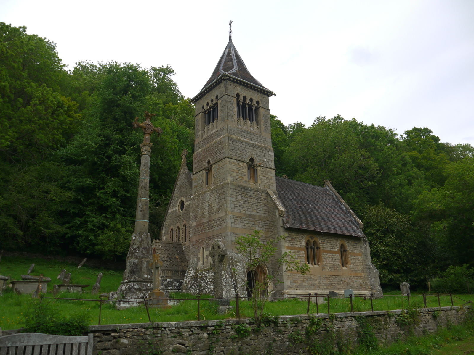
| Goodrich Church |
At Goodrich we passed by the church and headed on to find the pub where we stopped for a long cold drink - it was heavenly on such a (by now) hot day. We decided to stop in the nearby castle on the way by (the official walk starts at the car park) and this was a revelation. I have passed by a number of times and never thought too much about it as it didn't look that impressive. Yet up close I was rather surprised by the scale of it since the castle is sunk just below the brow of the hill. This has the effect of making the walls look a lot shorter than they actually are.
 |
| Goodrich Castle |
The castle has been here since Norman times and is still remarkably complete despite being rendered useless as a fortress by the implementation of 'Roaring Meg'; a large mortar used by Parliamentarian forces in the Civil War. This weapon also put paid to the castle at nearby Raglan. It seemed an ignominious end to a fortress that would once have defended the border between England and Wales so resolutely. The tour was a fascinating mix of its time as a fortress and home to a retinue of people that probably lived a relatively comfortable life compared to others in the surrounding countryside at that time.
 |
| Roaring Meg |
Sadly the glorious day that we had experienced up to now disappeared under increasing layers of cloud and before long the blue skies gave way to grey as we prepared to continue on our way. We thought about getting the bus the short distance down to Kerne Bridge so as to avoid further road walking (there was no serious alternative now) but in the event we thought we would try our lucj and walk instead. Thankfully this section has a nice pavement and so the bus was not required. We looked smugly at it passing as we were some way down the river bank leading away from Kerne Bridge.
 |
| Kerne Bridge |
Our route now took us along the banks of the River Way once again. We would follow the enormous meander loops, which meant that our walk of several miles didn't actually achieve very much distance compared to how the crow flies. The river was abuzz with canoeists, largely family groups but also groups of youngsters trying out for the first time by the looks of things. One group particularly caught our eyes - a group of young Eastern Asians (Japanese perhaps?) who were having the hardest time steering their craft and getting entangled in all manner of riverside vegetation as the current carried them in a more definite course than any of their steering could. They didn't seem to mind though - there was loud chatter and laughter coming from their craft as they all could see the funny side of their uselessness.
 |
| Wye Canoeing |
On the path we crossed what would once have been the Wye Valley Railway from Ross-on-Wye to Monmouth. The train would once have paused at Kerne Bridge (the station is still there!) on the opposite bank to our path before continuing on to Monmouth in the direction we were headed. The bridge over the Wye is long gone and the countryside a lot more wooded than it would once have been. The line disappeared into a tunnel cutting off the meander loop we were about to walk around and we would meet the other end later.
 |
| Ramsons Lined Path |
Our route alongside the Wye was largely very quiet with few other walkers about. The going was easy with grassy pasture land being the order of the day for much of the way. On the opposite of the river the valley sides were dotted with houses all taking advantage of the beautiful views on offer along this stretch. Our side was more remote - the effect of a piece of land being effectively cut off due to the lack of bridges along this part of the Wye. The only settlement on our side is the scattered village of Welsh Bicknor, which despite its name is not now in Wales but in Herefordshire. It was once a curious little enclave of Monmouthshire, hence its name. On the opposite side of the bank is perhaps inevitably English Bicknor.
 |
| Welsh Bicknor Church |
Eventually we reached the lovely little church of Welsh Bicknor and its Youth Hostel next door. Perhaps we should have stopped here for a cup of tea (we certainly needed it) but somehow the smell of raw sewage got up our nose and put us off. Instead we reached the other end of the old railway line as it emerged from the tunnel under Welsh Bicknor. This time I went up to find the tunnel mouth and what a sorry state the line now looks. It has been more than 55 years since the last train came this way and nature is reclaiming this man made structure very quickly. The cutting is full of water and the tunnel mouth suggests that any chance of a rebuilding of this railway is surely only a pipe dream by the most enthusiastic railway fans.
 |
| Lydbrook Bridge |
My wife and I had actually passed this way some years ago when walking some of the Wye Valley Walk but I have to say I was shocked at how much the old railway bridge carrying us over the Wye had deteriorated even since that time 12 years earlier. I wonder how long it can realistically carry the walkway over the river before the health and safety police do something about it? On the opposite side is the surprisingly large Lydbrook Wire Works, a factory that has been closed as long as I can remember. It all looks rather forlorn now and yet it seems surprising that something as large as this can have been left to rot for some many years, especially in such a beautiful area. Orignially there was a railway junction here with another line heading off through Lydbrook to Lydney via a massive viaduct which sadly succumbed to demolition in the mid 1960s. It would have been quite something to see an edifice like that still straddling the valley!
 |
| Lydbrook Wire Works |
Our route continued downstream using the old trackbed alongside the river all the way back to the foot of Symonds Yat rock. Unlike many other railways in this area engineering features were pretty few and far between and indeed it was difficult to even realise that we were walking along a railway until we got to the foot of the rock. Here the railway disappeared first into a dark and dank cutting and then into a tunnel that would have been really handy for us now! Sadly the only way we could get back to Symonds Yat was either the steep climb back over the rock or via a very long walk around the foot of the hill. We opted for the short steep climb to get back to our hotel - a wise choice I think...
 |
| Symonds Yat Tunnel |
This really is one of the finest places in England to walk - an area steeped in history as well as the most magnificent countryside. It isn't perhaps top of most people's lists of places to visit in England but I am glad for that - it is a secret that I want to keep!


What a great place the Wye Valley is...... Lots of memories for me here...thanks.
ReplyDelete